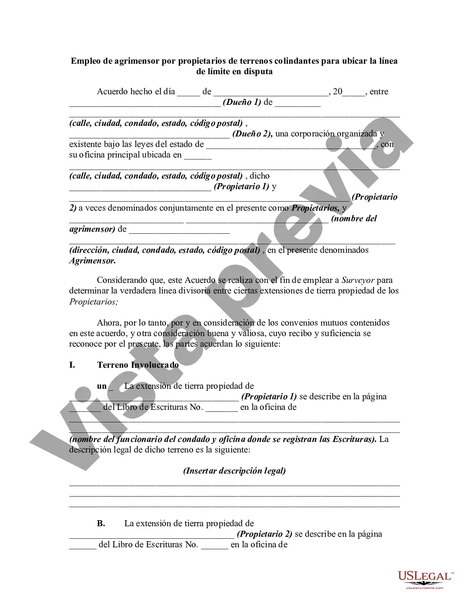
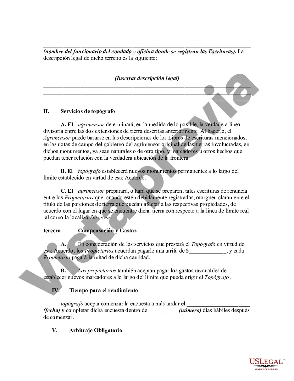
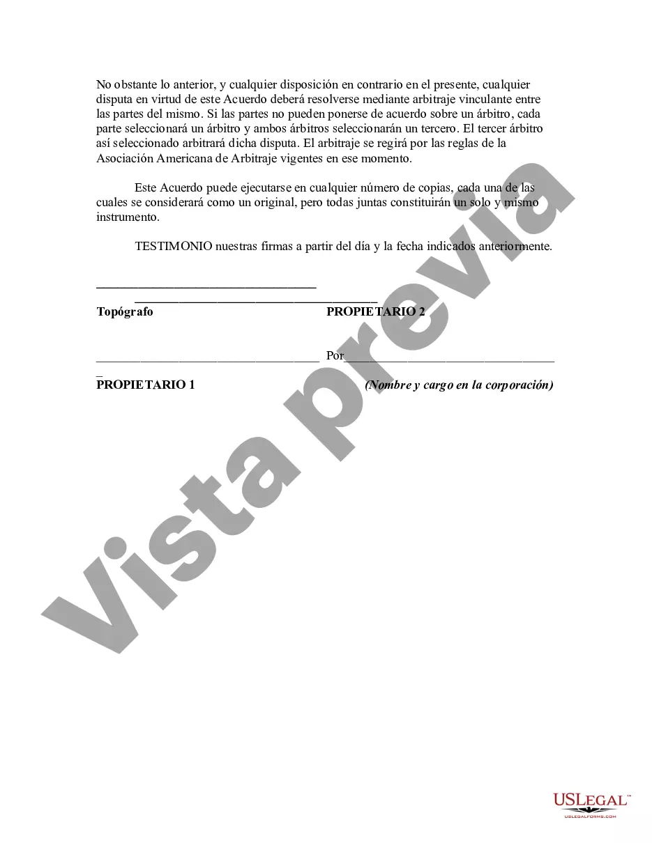
This is a generic sample of an agreement between two adjoining landowners to hire a surveyor to survey their lands in order to settle a dispute as to where the true boundary is regarding their properties.
Allegheny, Pennsylvania is a well-known county located in the western part of the state. Known for its beautiful landscapes, diverse communities, and vibrant economy, Allegheny County offers numerous opportunities for employment in various fields, including surveying. When it comes to boundary disputes between neighboring landowners in Allegheny, Pennsylvania, employing a surveyor is a crucial step in resolving conflicts over property lines. These professionals play a vital role in determining accurate boundary locations, ensuring proper property rights, and preventing any potential disputes in the future. By using advanced surveying techniques, such as GPS and GIS technology, the surveyor conducts thorough research, including reviewing historical documents and deed descriptions, to locate the disputed boundary line accurately. They also examine physical markers, evidence of prior surveys, and any available local records to establish a comprehensive understanding of the property in question. Adjoining landowners in Allegheny, Pennsylvania often seek the employment of a surveyor to resolve boundary disputes and gain clarity about their property boundaries. Depending on the unique characteristics of each case, different types of surveyors may be involved, such as: 1. Boundary Surveyors: Boundary surveyors are responsible for identifying and marking the exact location of property lines. They consider legal documents, physical features, and recorded information to produce accurate drawings and reports. 2. Geodetic Surveyors: Geodetic surveyors focus on measuring large areas and account for the Earth's curvature. They utilize geodetic data, advanced satellite technology, and precise measurements to establish accurate boundary lines. 3. Land Surveyors: Land surveyors specialize in measuring and mapping land, including both the natural and man-made features on a property. They employ a combination of traditional and modern surveying techniques to establish boundaries and create detailed surveys. 4. Topographic Surveyors: Topographic surveyors concentrate on measuring and mapping the contour and features of the land, such as hills, streams, trees, and buildings. They provide valuable information about the physical characteristics of the property, which can be essential when determining disputed boundary lines. 5. Construction Surveyors: In cases where disputed boundary lines might impact construction projects near the property, construction surveyors are employed. They work closely with engineers, architects, and builders to ensure that proposed structures adhere to property boundaries, codes, and regulations. In summary, when landowners in Allegheny, Pennsylvania need assistance in locating a disputed boundary line, employing a surveyor is vital. These professionals bring expertise, knowledge, and advanced technology to accurately determine property boundaries, resolve disputes, and provide valuable guidance to both parties involved.Allegheny, Pennsylvania is a well-known county located in the western part of the state. Known for its beautiful landscapes, diverse communities, and vibrant economy, Allegheny County offers numerous opportunities for employment in various fields, including surveying. When it comes to boundary disputes between neighboring landowners in Allegheny, Pennsylvania, employing a surveyor is a crucial step in resolving conflicts over property lines. These professionals play a vital role in determining accurate boundary locations, ensuring proper property rights, and preventing any potential disputes in the future. By using advanced surveying techniques, such as GPS and GIS technology, the surveyor conducts thorough research, including reviewing historical documents and deed descriptions, to locate the disputed boundary line accurately. They also examine physical markers, evidence of prior surveys, and any available local records to establish a comprehensive understanding of the property in question. Adjoining landowners in Allegheny, Pennsylvania often seek the employment of a surveyor to resolve boundary disputes and gain clarity about their property boundaries. Depending on the unique characteristics of each case, different types of surveyors may be involved, such as: 1. Boundary Surveyors: Boundary surveyors are responsible for identifying and marking the exact location of property lines. They consider legal documents, physical features, and recorded information to produce accurate drawings and reports. 2. Geodetic Surveyors: Geodetic surveyors focus on measuring large areas and account for the Earth's curvature. They utilize geodetic data, advanced satellite technology, and precise measurements to establish accurate boundary lines. 3. Land Surveyors: Land surveyors specialize in measuring and mapping land, including both the natural and man-made features on a property. They employ a combination of traditional and modern surveying techniques to establish boundaries and create detailed surveys. 4. Topographic Surveyors: Topographic surveyors concentrate on measuring and mapping the contour and features of the land, such as hills, streams, trees, and buildings. They provide valuable information about the physical characteristics of the property, which can be essential when determining disputed boundary lines. 5. Construction Surveyors: In cases where disputed boundary lines might impact construction projects near the property, construction surveyors are employed. They work closely with engineers, architects, and builders to ensure that proposed structures adhere to property boundaries, codes, and regulations. In summary, when landowners in Allegheny, Pennsylvania need assistance in locating a disputed boundary line, employing a surveyor is vital. These professionals bring expertise, knowledge, and advanced technology to accurately determine property boundaries, resolve disputes, and provide valuable guidance to both parties involved.
Para su conveniencia, debajo del texto en español le brindamos la versión completa de este formulario en inglés. For your convenience, the complete English version of this form is attached below the Spanish version.