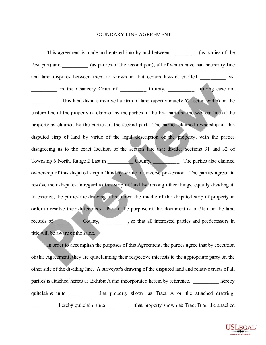
The Alaska Boundary Line Agreement refers to a historic agreement between the United States and Canada that determined the precise boundary line between the Alaska Territory of the United States and the Canadian provinces of British Columbia and Yukon. This agreement aimed to resolve a longstanding dispute over the exact border between these regions. The Alaska Boundary Line Agreement was signed on October 20, 1903, and remains a significant diplomatic milestone in the history of both countries. The agreement was mediated by a tribunal of three British jurists appointed by the British government, known as the Alaska Boundary Tribunal. The tribunal was tasked with interpreting an earlier treaty between Russia and Great Britain that defined the boundary between Alaska and British Columbia. The agreement establishes the boundary line from the Dixon Entrance, along the crest of certain mountain ranges, to the northernmost point of Portland Channel. From there, it continues along the main channel of Portland Canal to the 56th parallel of latitude, then follows that parallel eastward until it meets the mountain range separating Alaska from the Yukon. The boundary then follows the crest of these mountains to the 141st meridian of west longitude, where it meets the Arctic Ocean. The Alaska Boundary Line Agreement resulted in the determination of a single boundary line, resolving the dispute and setting a definitive border between Alaska and Canada's British Columbia and Yukon territories. It provided clarity for both countries' territorial claims and facilitated peaceful relations and cooperation in the region. It is important to note that there are no different types of Alaska Boundary Line Agreements. However, there have been subsequent agreements and treaties between the United States and Canada related to other boundary disputes and management of shared natural resources in the region, such as the Alaska-Canada border dispute over the Beaufort Sea and the management of transboundary water resources.
Alaska Boundary Line Agreement
Description


How to fill out Alaska Boundary Line Agreement?
You can devote time online searching for the legal document template that meets the federal and state standards you require.
US Legal Forms provides a vast array of legal documents that can be reviewed by professionals.
It is easy to obtain or print the Alaska Boundary Line Agreement from my service.
If available, use the Preview button to review the document template as well.
- If you possess a US Legal Forms account, you can sign in and click on the Download button.
- Then, you can complete, modify, print, or sign the Alaska Boundary Line Agreement.
- Every legal document template you obtain is yours permanently.
- To get another copy of a purchased document, go to the My documents tab and click on the corresponding button.
- If you are using the US Legal Forms website for the first time, follow the simple instructions below.
- First, ensure that you have chosen the correct document template for the state/city of your choice.
- Check the document description to confirm you have selected the correct document.
Form popularity
FAQ
A boundary agreement is a legal document created to establish and clarify the specific lines dividing adjacent properties. It serves to eliminate ambiguity and prevent disputes about property lines. An Alaska Boundary Line Agreement is crucial for landowners in Alaska, as it provides a formal record of the agreed-upon boundaries, serving as protection for both property owners.
A line agreement is essentially a legal document that establishes property lines between landowners. It helps define ownership and prevents misunderstandings regarding property limits. An Alaska Boundary Line Agreement fulfills this role, ensuring both parties have the same understanding of their property boundaries, which can foster a more harmonious neighborhood.
A line agreement typically refers to an agreement that defines the boundary lines between adjacent properties. In the context of property ownership, an Alaska Boundary Line Agreement serves a similar purpose by clearly stating where one property ends and another begins, helping to prevent conflicts and confusion among neighbors.
An easement grants permission for one party to use a portion of another party's property for a specific purpose, while a boundary line agreement clarifies property lines between adjacent landowners. An Alaska Boundary Line Agreement establishes clear delineations and can prevent disputes between neighbors, making it essential for property owners who want to ensure their boundaries are recognized and respected.
Acquiescence in property law signifies a situation where one property owner allows another to use their land without formal objections over time, potentially leading to a prescriptive easement or boundary rights. This principle is particularly important in resolving boundary disputes. By utilizing an Alaska Boundary Line Agreement, property owners can document their understanding and usage, ultimately preventing misunderstandings and legal battles.
An example of the law of acquiescence involves two neighbors who have lived adjacent to each other for many years. If one neighbor has consistently maintained a fence that is actually a few feet inside their legal boundary, and the other neighbor has accepted this arrangement without protest, the first neighbor may acquire legal rights to that land. An Alaska Boundary Line Agreement can help formalize such arrangements, ensuring both parties' interests are protected.
The legal meaning of acquiescence involves a party's passive acceptance of a situation or condition that is legally relevant. In property disputes, this often relates to how land has been used or occupied without formal challenge. Recognizing your rights through an Alaska Boundary Line Agreement can help clarify your position and avoid potential legal issues related to acquiescence.
To prove the boundary of acquiescence, property owners typically need to gather evidence such as historical documents, surveys, or witness testimonies that demonstrate long-term use or acknowledgment of the boundary in question. This evidence shows that both parties have accepted the boundary over time without objections. Utilizing an Alaska Boundary Line Agreement can solidify this understanding, preventing any future confusion.
A boundary agreement is a legal document that establishes the precise location of property lines between neighboring landowners. It helps prevent future disputes by detailing the extent of each party's property rights. When you enter into an Alaska Boundary Line Agreement, you create a clear understanding of boundaries that can safeguard your property against misunderstandings and legal issues.
Acquiescence property law refers to a legal principle that allows a property owner to claim a portion of land if they have allowed another person to use or occupy that land without objection for a specific duration. This principle often plays a role in settling disputes related to property boundaries. In the context of an Alaska Boundary Line Agreement, understanding acquiescence can be crucial for property owners who want to formalize their land usage and avoid conflicts.