Alabama Seismic Data and Operations

State:
Multi-State
Control #:
US-OG-720
Format:
Word; 
Rich Text
Instant download

Description

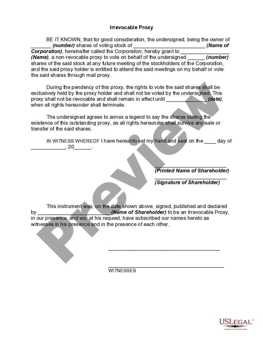
This form is used when the Parties agree and shall contribute all proprietary seismic data and all non-proprietary seismic data affecting the Contract Area in its possession as of the effective date of this Agreement, to the extent the data is not restricted by confidentiality or licensing agreements with third parties. It is specifically understood and agreed that each Party has the right to sell, trade, and/or otherwise market seismic data involving the Contract Area which was in its possession prior to the effective date of this Agreement, and the benefits and advantages, including monetary consideration, which it receives as a result of those activities shall be the sole property of the party who owns the data.

Alabama Seismic Data and Operations involve the collection, processing, and analysis of data related to seismic activity in the state of Alabama. Seismic data refers to the measurements and recordings of vibrations, waves, and ground movements caused by earthquakes, underground explosions, or other geological events. These activities are crucial for monitoring and understanding the geological processes occurring beneath the surface, which helps in assessing potential seismic hazards, planning infrastructure, and ensuring public safety. Keywords: — Alabama: The state of Alabama, located in the southeastern region of the United States. — Seismic Data: Measurements and recordings of vibrations, waves, and ground movements caused by earthquakes, underground explosions, or other geological events. — Operations: Activities related to the collection, processing, and analysis of seismic data. — Seismic Activity: Natural or induced occurrences resulting in the release of energy within the Earth's crust that shake the ground surface. — Collection: The process of gathering seismic data through the use of seismometers, accelerometers, and other monitoring equipment. — Processing: The manipulation and organization of collected data to enhance its quality and extract valuable information. — Analysis: The examination and interpretation of processed seismic data to identify patterns, trends, and geological information. — Geological Processes: Natural activities that shape the Earth's crust, such as tectonic plate movement, faulting, and volcanism. — Seismic Hazards: Potential dangers to life and property caused by seismic activity, including ground shaking, landslides, and tsunamis. — Infrastructure Planning: Development and design of buildings, bridges, roads, and other critical structures that can withstand seismic forces. — Public Safety: Measures taken to protect the well-being of the public from potential seismic hazards. Different types of Alabama Seismic Data and Operations may include: 1. Earthquake Monitoring: Collecting and analyzing data on earthquakes occurring within the state of Alabama. This data helps in determining earthquake locations, magnitudes, and depths, providing valuable insights into local seismic activity. 2. Induced Basicity Assessment: Studying seismic events caused by human activities, such as hydraulic fracturing (fracking) or wastewater injection. Assessing the potential risks and monitoring induced basicity ensures the safe extraction of natural resources. 3. Hazard Mapping: Creating maps and models that depict areas prone to seismic hazards, such as liquefaction zones, landslide potential, and areas susceptible to strong ground shaking. These maps help inform land-use planning and building codes. 4. Seismic Retrofitting: Developing and implementing strategies to strengthen existing structures against seismic forces. This involves analyzing data to identify vulnerable buildings and recommending modifications to enhance their resistance to earthquakes. 5. Public Education and Preparedness: Disseminating information to raise awareness about seismic hazards and promoting preparedness measures among the public. This may include educational campaigns, emergency drills, and guidance on creating personal emergency plans. Overall, Alabama Seismic Data and Operations play a vital role in monitoring and understanding seismic activity, assessing hazards, ensuring infrastructure resilience, and safeguarding public safety in the state of Alabama.

How to fill out Alabama Seismic Data And Operations?

You may spend time on-line looking for the authorized file template that suits the federal and state needs you need. US Legal Forms gives 1000s of authorized types which are analyzed by pros. It is possible to down load or print out the Alabama Seismic Data and Operations from our support.

If you already possess a US Legal Forms bank account, you may log in and then click the Download option. Next, you may full, modify, print out, or signal the Alabama Seismic Data and Operations. Every authorized file template you get is your own permanently. To have another backup associated with a purchased kind, go to the My Forms tab and then click the related option.

If you are using the US Legal Forms website the very first time, stick to the straightforward instructions below:

  • Initially, ensure that you have selected the right file template for your state/area of your choice. See the kind outline to ensure you have picked out the correct kind. If accessible, make use of the Preview option to search throughout the file template as well.
  • If you want to discover another variation in the kind, make use of the Research field to get the template that meets your requirements and needs.
  • Once you have located the template you need, click Purchase now to move forward.
  • Pick the rates prepare you need, enter your references, and register for a merchant account on US Legal Forms.
  • Comprehensive the deal. You can use your charge card or PayPal bank account to purchase the authorized kind.
  • Pick the file format in the file and down load it in your system.
  • Make modifications in your file if possible. You may full, modify and signal and print out Alabama Seismic Data and Operations.

Download and print out 1000s of file templates while using US Legal Forms Internet site, that offers the most important variety of authorized types. Use skilled and condition-specific templates to deal with your business or person requirements.

Form popularity

FAQ

The 1916 Irondale earthquake struck in the north?central region of the U.S. state of Alabama on October 18. The strongest earthquake in state history, it registered an estimated Richter scale magnitude of 5.1 and resulted in minor damage.

Earthquake Hazard level: Low ? In the area you have selected (Alabama) earthquake hazard is classified as low ing to the information that is currently available.

Seismic waves lose much of their energy in traveling over great distances. But sensitive detectors (seismometers) can record theses waves emitted by even the smallest earthquakes. When these detectors are connected to a system that produces a permanent recording, they are called seismographs.

Most of the earthquakes we experience in Alabama are associated with the Southern Appalachian Seismic Zone (an extension of the East Tennessee Seismic Zone) that runs along the Appalachian Mountains from the northeastern corner into the central part of the state and the Bahamas Fracture Seismic Zone in southern Alabama ...

The 1916 Irondale earthquake struck in the north?central region of the U.S. state of Alabama on October 18. The strongest earthquake in state history, it registered an estimated Richter scale magnitude of 5.1 and resulted in minor damage.

In northern Alabama, earthquakes are associated with the Southern Appalachian Seismic Zone while southern Alabama is impacted by the Bahamas Fracture Seismic Zone. Just to the northwest, there is the New Madrid Fault, this impacts portions of Arkansas, Illinois, Indiana, Kentucky, Mississippi, Missouri, and Tennessee.

Ing to the Geological Survey of Alabama, there are four zones of frequent earthquake activity with the potential to affect Alabama: the new Madrid Seismic Zone, the Southern Appalachian Seismic Zone, the South Carolina Seismic Zone, and the Bahamas Fracture Seismic Zone.

The quake was detected about 4.3 miles below the ground. It's the first earthquake detected in Alabama in 2023, though there have been several this year in northwest Georgia near the Alabama state line.

More info

by D Hills · 2019 — Work by the GSA for this project emcompassed three main objectives: 1) to conduct seismic interpretation over the study area to demonstrate the areal extent and ... As Alabama is affected by three seismic zones (fig. 1) – the New Madrid Seismic Zone (NMSZ), the East. Tennessee Seismic Zone (ETSZ), and Bahamas Fracture ...by JG Flocks · 2023 — This study is the first task of the Bureau of Ocean Energy Management Intra-agency agreement. M21PG00012 “(1) Analysis of Digitally Recovered Single-Channel ... How to Write SEED Data. 19. Procedure ... ence includes constructing other special seismic data distribution formats; in coordinating computer, operating system,. Since the 1800s, GSA has mapped the distribution of these rocks and their characteristics and can provide data, maps, and reports related to the underlying ... by R Trautz · 2020 · Cited by 13 — Geophysical monitoring using active seismic techniques at the Citronelle Alabama CO2 storage demonstration site. Although the investigation was exclusive to state waters, the seismic and vibracore data collected provided valuable insight into transverse ridge sand deposits ... 7 May 2020 — For most areas, it is relatively easy to compile a record of historical earthquake activity online. Earthquake catalog searches (described above) ... Description. AL earthquake spreadsheet, GSA, Earthquake data (Excel file). AL ... Seismic hazards based on probability of exceeding shaking within a given time ... describes in detail how to complete the Level 1 Data Collection Form, and ... • Selection of the Data Collection Form based on the seismic hazard and review and ...

Trusted and secure by over 3 million people of the world’s leading companies

Alabama Seismic Data and Operations