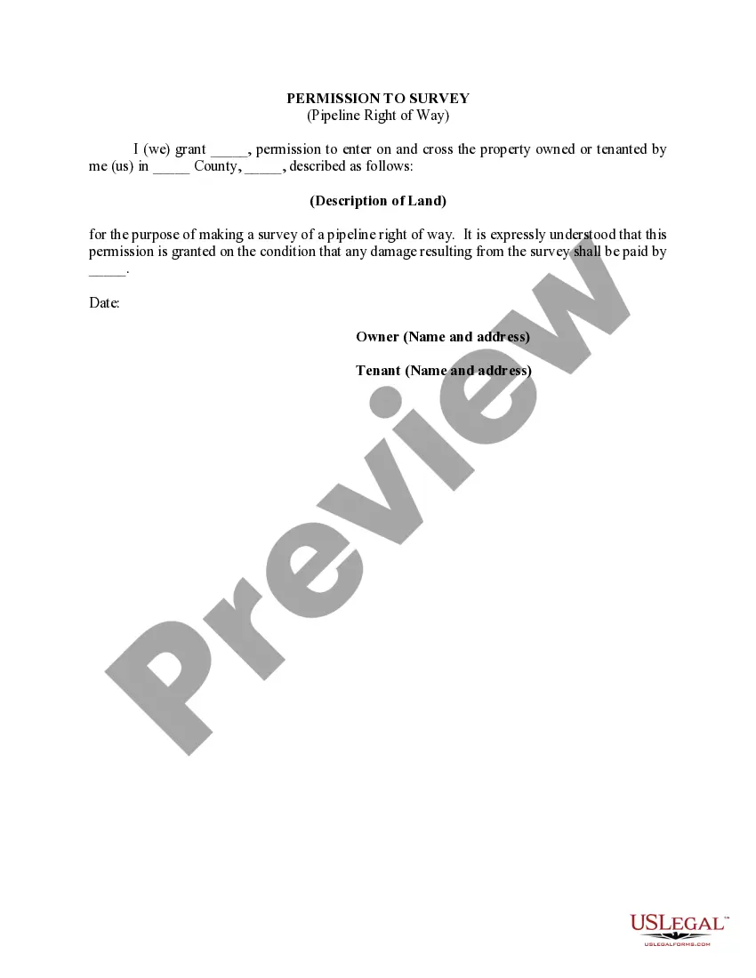
Arkansas Permission to Survey (Pipeline Right of Way): A Comprehensive Guide Introduction: The Arkansas Permission to Survey (Pipeline Right of Way) is a legal authorization granted by the state of Arkansas for surveyors to carry out necessary activities before the installation, maintenance, or expansion of pipelines. This permission provides access and legal rights to surveyors to assess land conditions, conduct studies, and plan the route for pipelines, ensuring compliance with state regulations and minimizing potential environmental impacts. In Arkansas, there are different types of Permission to Survey (Pipeline Right of Way), including Temporary Permission to Survey and Permanent Permission to Survey. 1. Temporary Permission to Survey: Temporary Permission to Survey is a type of authorization granted for a limited period to surveyors involved in short-term pipeline projects. It is typically obtained when conducting surveys for construction, maintenance, or repair work on existing pipeline infrastructure. This permission allows surveyors to access private and public lands temporarily, conduct necessary surveys, and gather required data to ensure efficient project planning and execution. 2. Permanent Permission to Survey: Permanent Permission to Survey is an authorization issued for long-term or permanent projects like the construction of new pipelines or major expansion of existing ones. This permission provides surveyors unrestricted access to specified lands for an extended period, allowing them to conduct comprehensive surveys, geological studies, and other assessments necessary for safe and efficient pipeline installation or expansion. 3. Process for Obtaining Arkansas Permission to Survey (Pipeline Right of Way): To obtain Arkansas Permission to Survey (Pipeline Right of Way), the following steps are usually involved: a. Application Submission: The interested party or pipeline operator submits a formal application to the appropriate regulatory authority in Arkansas. The application typically includes project details, landowners' consent (if applicable), proposed route maps, environmental impact assessments, and relevant permits. b. Evaluation and Approval: The regulatory authority evaluates the application, ensuring compliance with state regulations, environmental laws, and safety standards. A detailed review of the proposed project, land ownership, potential impacts, and mitigation plans is conducted. Once approved, the applicant is granted Arkansas Permission to Survey, outlining the specific terms, conditions, and limitations for the survey work. c. Survey Execution: Surveyors proceed with the approved pipeline project, adhering to the terms and conditions defined in the Permission to Survey. Landowners' rights, environmental protection measures, and safety protocols are strictly followed during the survey, ensuring minimal disruption to property owners and ecosystems. d. Renewal and Modification: Depending on the project's duration and requirements, the Permission to Survey might need periodic renewals. Additionally, if any modifications are planned during the pipeline project, such as changes in the route or expansion plans, a revised Application for Permission to Survey may need to be submitted for approval. Conclusion: Obtaining Arkansas Permission to Survey (Pipeline Right of Way) is a crucial step in pipeline project planning and execution. It ensures compliance with state regulations, facilitates efficient project development, and protects landowners' rights and the environment. Whether it is Temporary Permission to Survey for short-term projects or Permanent Permission to Survey for long-lasting ventures, proper authorization plays a vital role in initiating pipeline construction while adhering to legal obligations and environmental considerations.
Arkansas Permission to Survey (Pipeline Right of Way): A Comprehensive Guide Introduction: The Arkansas Permission to Survey (Pipeline Right of Way) is a legal authorization granted by the state of Arkansas for surveyors to carry out necessary activities before the installation, maintenance, or expansion of pipelines. This permission provides access and legal rights to surveyors to assess land conditions, conduct studies, and plan the route for pipelines, ensuring compliance with state regulations and minimizing potential environmental impacts. In Arkansas, there are different types of Permission to Survey (Pipeline Right of Way), including Temporary Permission to Survey and Permanent Permission to Survey. 1. Temporary Permission to Survey: Temporary Permission to Survey is a type of authorization granted for a limited period to surveyors involved in short-term pipeline projects. It is typically obtained when conducting surveys for construction, maintenance, or repair work on existing pipeline infrastructure. This permission allows surveyors to access private and public lands temporarily, conduct necessary surveys, and gather required data to ensure efficient project planning and execution. 2. Permanent Permission to Survey: Permanent Permission to Survey is an authorization issued for long-term or permanent projects like the construction of new pipelines or major expansion of existing ones. This permission provides surveyors unrestricted access to specified lands for an extended period, allowing them to conduct comprehensive surveys, geological studies, and other assessments necessary for safe and efficient pipeline installation or expansion. 3. Process for Obtaining Arkansas Permission to Survey (Pipeline Right of Way): To obtain Arkansas Permission to Survey (Pipeline Right of Way), the following steps are usually involved: a. Application Submission: The interested party or pipeline operator submits a formal application to the appropriate regulatory authority in Arkansas. The application typically includes project details, landowners' consent (if applicable), proposed route maps, environmental impact assessments, and relevant permits. b. Evaluation and Approval: The regulatory authority evaluates the application, ensuring compliance with state regulations, environmental laws, and safety standards. A detailed review of the proposed project, land ownership, potential impacts, and mitigation plans is conducted. Once approved, the applicant is granted Arkansas Permission to Survey, outlining the specific terms, conditions, and limitations for the survey work. c. Survey Execution: Surveyors proceed with the approved pipeline project, adhering to the terms and conditions defined in the Permission to Survey. Landowners' rights, environmental protection measures, and safety protocols are strictly followed during the survey, ensuring minimal disruption to property owners and ecosystems. d. Renewal and Modification: Depending on the project's duration and requirements, the Permission to Survey might need periodic renewals. Additionally, if any modifications are planned during the pipeline project, such as changes in the route or expansion plans, a revised Application for Permission to Survey may need to be submitted for approval. Conclusion: Obtaining Arkansas Permission to Survey (Pipeline Right of Way) is a crucial step in pipeline project planning and execution. It ensures compliance with state regulations, facilitates efficient project development, and protects landowners' rights and the environment. Whether it is Temporary Permission to Survey for short-term projects or Permanent Permission to Survey for long-lasting ventures, proper authorization plays a vital role in initiating pipeline construction while adhering to legal obligations and environmental considerations.