Arizona Seismic Data and Operations

State:
Multi-State
Control #:
US-OG-720
Format:
Word; 
Rich Text
Instant download

Description

This form is used when the Parties agree and shall contribute all proprietary seismic data and all non-proprietary seismic data affecting the Contract Area in its possession as of the effective date of this Agreement, to the extent the data is not restricted by confidentiality or licensing agreements with third parties. It is specifically understood and agreed that each Party has the right to sell, trade, and/or otherwise market seismic data involving the Contract Area which was in its possession prior to the effective date of this Agreement, and the benefits and advantages, including monetary consideration, which it receives as a result of those activities shall be the sole property of the party who owns the data.

Arizona Seismic Data and Operations refer to the collection, analysis, and management of seismic information in the state of Arizona. Seismic data, in this context, includes data obtained from seismic monitoring systems, instruments, and networks that measure and record ground movements caused by earthquakes, explosions, and other sources of seismic activities. The Arizona Geological Survey (AGS) operates and oversees the seismic data and operations in the state. AGS collaborates with various institutions, organizations, and agencies to ensure the accurate monitoring and assessment of seismic events and potential hazards in Arizona. The primary goal of Arizona Seismic Data and Operations is to understand the basicity and associated risks in the state, improving the preparedness, response, and mitigation efforts against earthquakes and other seismic hazards. The collected data is crucial for scientists, engineers, emergency managers, and policymakers to make informed decisions regarding land use planning, construction, infrastructure development, and public safety. Different types of Arizona Seismic Data and Operations include: 1. Seismic Monitoring Systems: These are networks of seismographic stations strategically placed across Arizona to detect and record seismic activities. The stations consist of instruments such as seismometers, accelerometers, and data loggers that measure ground motions and transmit the data to a central database. 2. Seismic Event Catalog: AGS maintains a comprehensive catalog of seismic events in Arizona, including earthquake epicenters, magnitudes, depths, and other relevant parameters. This catalog helps understand the distribution, frequency, and characteristics of seismic activity. 3. Seismic Hazard Assessments: Geoscientists analyze the collected data to assess the seismic hazard potential in Arizona. This involves evaluating the probability of future seismic events, estimating ground shaking intensities, and identifying areas prone to higher seismic risks. 4. Earthquake Early Warning System: AGS is actively involved in researching and developing an earthquake early warning system for Arizona. This system uses real-time seismic data to detect earthquakes and provide alerts to minimize potential damages and casualties. 5. Research and Analysis: Arizona Seismic Data and Operations support various research projects focusing on understanding the tectonic activity, fault systems, and geological structures that influence basicity in the state. This research contributes to enhancing our understanding of earthquakes and improving seismic hazard assessments. 6. Public Outreach and Education: AGS organizes educational programs, workshops, and outreach events to raise public awareness about earthquakes, seismic safety, and the importance of seismic data. These initiatives aim to educate communities and individuals on preparedness measures and response strategies during seismic events. In conclusion, Arizona Seismic Data and Operations encompass the collection, analysis, and management of seismic information in the state. This vital information helps in understanding seismic hazards, developing early warning systems, and improving public safety and preparedness.

Arizona Seismic Data and Operations refer to the collection, analysis, and management of seismic information in the state of Arizona. Seismic data, in this context, includes data obtained from seismic monitoring systems, instruments, and networks that measure and record ground movements caused by earthquakes, explosions, and other sources of seismic activities. The Arizona Geological Survey (AGS) operates and oversees the seismic data and operations in the state. AGS collaborates with various institutions, organizations, and agencies to ensure the accurate monitoring and assessment of seismic events and potential hazards in Arizona. The primary goal of Arizona Seismic Data and Operations is to understand the basicity and associated risks in the state, improving the preparedness, response, and mitigation efforts against earthquakes and other seismic hazards. The collected data is crucial for scientists, engineers, emergency managers, and policymakers to make informed decisions regarding land use planning, construction, infrastructure development, and public safety. Different types of Arizona Seismic Data and Operations include: 1. Seismic Monitoring Systems: These are networks of seismographic stations strategically placed across Arizona to detect and record seismic activities. The stations consist of instruments such as seismometers, accelerometers, and data loggers that measure ground motions and transmit the data to a central database. 2. Seismic Event Catalog: AGS maintains a comprehensive catalog of seismic events in Arizona, including earthquake epicenters, magnitudes, depths, and other relevant parameters. This catalog helps understand the distribution, frequency, and characteristics of seismic activity. 3. Seismic Hazard Assessments: Geoscientists analyze the collected data to assess the seismic hazard potential in Arizona. This involves evaluating the probability of future seismic events, estimating ground shaking intensities, and identifying areas prone to higher seismic risks. 4. Earthquake Early Warning System: AGS is actively involved in researching and developing an earthquake early warning system for Arizona. This system uses real-time seismic data to detect earthquakes and provide alerts to minimize potential damages and casualties. 5. Research and Analysis: Arizona Seismic Data and Operations support various research projects focusing on understanding the tectonic activity, fault systems, and geological structures that influence basicity in the state. This research contributes to enhancing our understanding of earthquakes and improving seismic hazard assessments. 6. Public Outreach and Education: AGS organizes educational programs, workshops, and outreach events to raise public awareness about earthquakes, seismic safety, and the importance of seismic data. These initiatives aim to educate communities and individuals on preparedness measures and response strategies during seismic events. In conclusion, Arizona Seismic Data and Operations encompass the collection, analysis, and management of seismic information in the state. This vital information helps in understanding seismic hazards, developing early warning systems, and improving public safety and preparedness.

How to fill out Arizona Seismic Data And Operations?

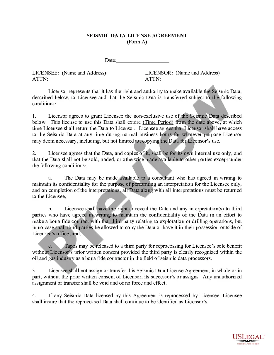
Are you presently in the place where you will need documents for either organization or specific uses just about every day time? There are tons of lawful papers themes available on the net, but getting ones you can depend on is not straightforward. US Legal Forms offers a huge number of develop themes, just like the Arizona Seismic Data and Operations, that are published to satisfy state and federal needs.

Should you be previously knowledgeable about US Legal Forms web site and have a free account, just log in. Following that, you are able to obtain the Arizona Seismic Data and Operations template.

Should you not provide an bank account and need to start using US Legal Forms, adopt these measures:

  1. Get the develop you want and ensure it is for the right city/county.
  2. Use the Review button to examine the shape.
  3. Browse the outline to ensure that you have chosen the appropriate develop.
  4. In the event the develop is not what you are searching for, use the Lookup discipline to discover the develop that meets your requirements and needs.
  5. Once you find the right develop, click Acquire now.
  6. Choose the costs plan you desire, fill out the desired details to make your account, and purchase your order making use of your PayPal or Visa or Mastercard.
  7. Choose a handy document formatting and obtain your version.

Locate all the papers themes you may have purchased in the My Forms menus. You can obtain a further version of Arizona Seismic Data and Operations at any time, if required. Just select the essential develop to obtain or produce the papers template.

Use US Legal Forms, the most substantial selection of lawful types, in order to save time and avoid blunders. The service offers appropriately made lawful papers themes that can be used for an array of uses. Make a free account on US Legal Forms and commence creating your way of life easier.

Trusted and secure by over 3 million people of the world’s leading companies

Arizona Seismic Data and Operations