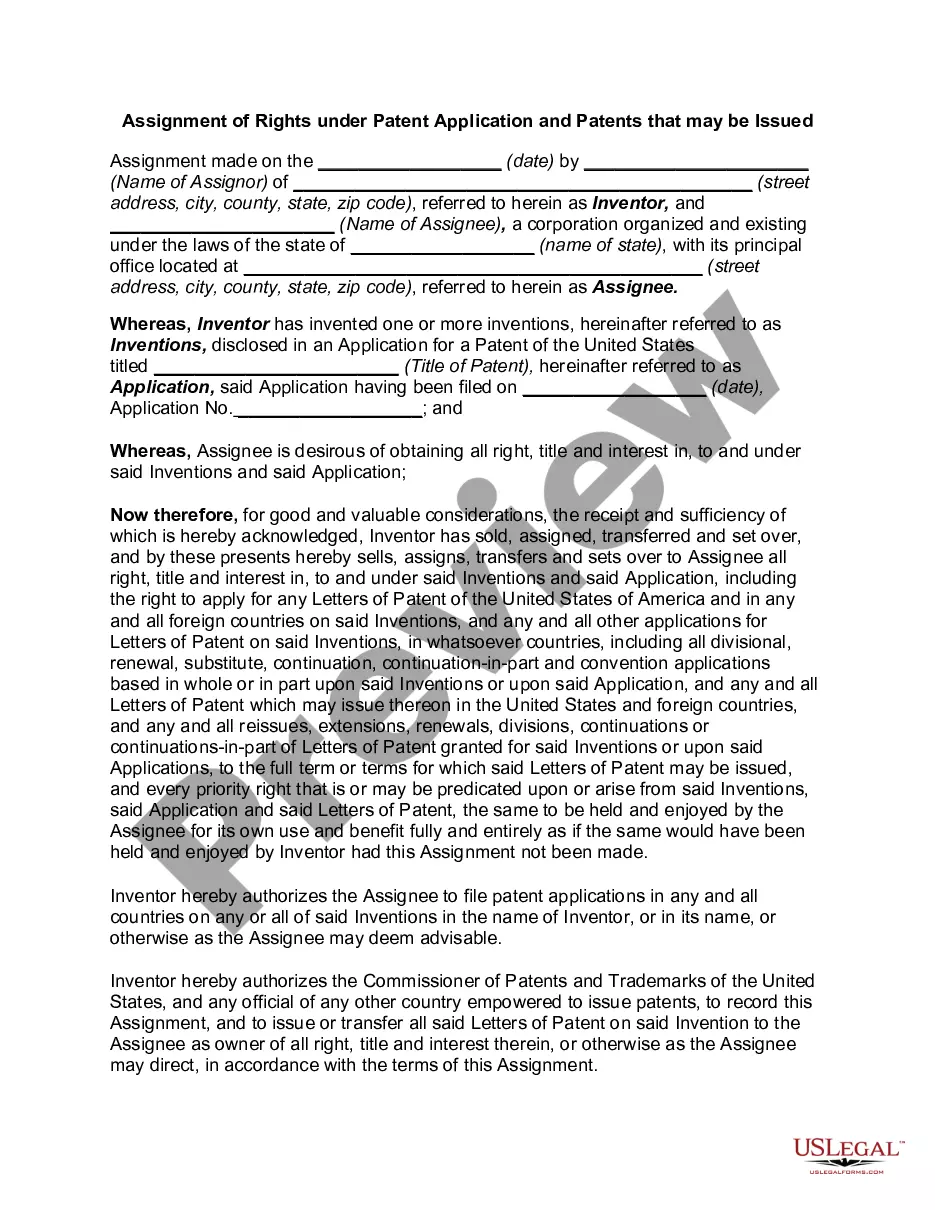
This lease rider form may be used when you are involved in a lease transaction, and have made the decision to utilize the form of Oil and Gas Lease presented to you by the Lessee, and you want to include additional provisions to that Lease form to address specific concerns you may have, or place limitations on the rights granted the Lessee in the “standard” lease form.
California Geophysical and Seismic Operations
Category:
State:
Multi-State
Control #:
US-OG-800
Format:
Word;
Rich Text
Instant download
Description
Free preview


How to fill out Geophysical And Seismic Operations?
You may commit time on the Internet searching for the lawful papers format that meets the state and federal specifications you require. US Legal Forms provides a large number of lawful kinds which are analyzed by pros. You can easily acquire or print the California Geophysical and Seismic Operations from your service.
If you already have a US Legal Forms accounts, you are able to log in and then click the Acquire switch. Afterward, you are able to total, change, print, or indicator the California Geophysical and Seismic Operations. Every single lawful papers format you purchase is your own permanently. To acquire an additional backup associated with a purchased develop, proceed to the My Forms tab and then click the related switch.
If you use the US Legal Forms website initially, keep to the simple guidelines under:
- First, make certain you have chosen the best papers format for your region/area of your choice. Browse the develop description to make sure you have selected the right develop. If available, make use of the Preview switch to look throughout the papers format also.
- If you would like get an additional edition of the develop, make use of the Research discipline to discover the format that meets your requirements and specifications.
- Once you have found the format you need, just click Buy now to carry on.
- Choose the prices strategy you need, type your references, and register for an account on US Legal Forms.
- Full the transaction. You can use your bank card or PayPal accounts to fund the lawful develop.
- Choose the formatting of the papers and acquire it to the product.
- Make adjustments to the papers if necessary. You may total, change and indicator and print California Geophysical and Seismic Operations.
Acquire and print a large number of papers themes using the US Legal Forms Internet site, which provides the greatest variety of lawful kinds. Use professional and condition-specific themes to handle your organization or personal requirements.
Form popularity
FAQ
If you are unsure of what Seismic Design Category (SDC) your project may fall under it can typically be found in the structural notes section of your construction drawings, or they may also be listed in the project specification.
The easiest way is to find out?? if a property is located in a Seismic Hazard Zone is to use the California Earthquake Hazards Zone Application?? or search our collection of online maps. You can also visit one of the California Geological Survey offices? (call ahead), or your city or county office.
There are four zones, with Zone 1 being the least threatened by seismic activity, and Zone 4 being the most threatened (ie. areas near an active fault line).
General Offshore Geophysical Survey Permit This nonexclusive permit authorizes geophysical survey activity during the permit term. A General Offshore Geophysical Survey Permit is required for geophysical surveys utilizing low-energy equipment conducted in marine waters under the jurisdiction of the Commission.
The NCSN operates 580 stations in northern and central California and records an additional 159 stations maintained by the Southern California Seismic Network, Pacific Gas & Electric, the University of Nevada Reno, the California Department of Water Resources, Calpine/LBNL, and the California Geological Survey.
The California Geological Survey (CGS) is dedicated to providing scientific products and services about the state's geology, seismology, and mineral resources that affect the health, safety, and business interests of the people of California.
The easiest way is to find out?? if a property is located in a Seismic Hazard Zone is to use the California Earthquake Hazards Zone Application?? or search our collection of online maps. You can also visit one of the California Geological Survey offices? (call ahead), or your city or county office.
To determine property location relative to a zone boundary, please visit your local planning agency to view appropriate Official Seismic Hazard, Earthquake Fault Zone maps, and parcel maps.