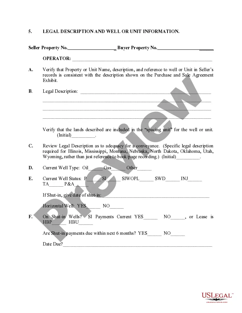
Connecticut Legal Description and Well or Unit Information serves as vital documentation in the oil and gas industry. It includes precise details about the location, boundaries, and ownership of a piece of land, as well as information regarding the status and operations of wells and units on that land. Connecticut Legal Description: When it comes to real estate or mineral rights transactions in Connecticut, a legal description is crucial. A Connecticut legal description typically consists of two key components: the metes and bounds description and the lot and block description. 1. Metes and Bounds Description: This description uses physical features, measurements, and directional bearings to outline the boundaries of a property. It starts at a fixed point and provides a series of distances and angles that form the perimeter. For example, "From the northwest corner of Section 7, Township 5 North, Range 3 West, proceed east 500 feet." 2. Lot and Block Description: This description assigns lot numbers to specific tracts of land within a subdivision. Frequently used in urban areas, it refers to recorded plats or maps that divide the land into lots, blocks, and subdivisions. For example, "Lot 23, Block B, Smith's Subdivision." Well or Unit Information: Well or unit information pertains to the specific details of oil and gas wells, leaseholds, and units located on a piece of land. Connecticut has various types of well or unit information, including the following: 1. Well Information: This section provides comprehensive data relating to drilling operations, including the well's unique identifier or API (American Petroleum Institute) number, well bore characteristics, production history, and geological formations encountered. Well information is central in monitoring the performance, productivity, and compliance of oil and gas wells in Connecticut. 2. Leasehold Information: Leasehold information describes the legal agreements granting mineral rights exploration and exploitation on a specific parcel of land. It includes lease expiration dates, rental obligations, royalty percentages, and specific provisions governing drilling and extraction activities. Accurate leasehold information is critical for companies to track ownership and tenure rights. 3. Unit Information: Units are created when multiple landowners or leaseholds agree to pool their resources and interests to allow the efficient development of a common geological formation. Unit information provides the details of unitization agreements, participation percentages, allocation formulas, and the legal parameters governing collective drilling, production, and revenue distribution. 4. Production Information: This category encompasses vital information regarding the daily, monthly, and cumulative oil or gas production from wells or units on a particular tract of land. It includes production rates, volumes, market prices, and revenue generated. In summary, Connecticut Legal Description and Well or Unit Information act as essential records in the oil and gas industry. They capture the precise boundaries, ownership, and operational aspects of the land, wells, and units, enabling informed decision-making, regulatory compliance, and efficient resource management.
Connecticut Legal Description and Well or Unit Information
Description
How to fill out Connecticut Legal Description And Well Or Unit Information?
US Legal Forms - one of the biggest libraries of legal forms in the United States - offers an array of legal file themes it is possible to down load or produce. Using the web site, you may get thousands of forms for business and personal functions, categorized by groups, suggests, or keywords.You will find the latest types of forms just like the Connecticut Legal Description and Well or Unit Information in seconds.
If you currently have a membership, log in and down load Connecticut Legal Description and Well or Unit Information from the US Legal Forms local library. The Acquire switch can look on every develop you view. You gain access to all in the past downloaded forms inside the My Forms tab of the bank account.
If you would like use US Legal Forms for the first time, listed below are easy guidelines to obtain began:
- Ensure you have selected the correct develop for the city/area. Click the Review switch to analyze the form`s information. Read the develop explanation to actually have chosen the appropriate develop.
- In case the develop doesn`t match your demands, take advantage of the Search field near the top of the monitor to discover the one that does.
- When you are content with the form, confirm your choice by simply clicking the Buy now switch. Then, select the costs prepare you favor and provide your qualifications to register on an bank account.
- Process the transaction. Use your charge card or PayPal bank account to finish the transaction.
- Select the format and down load the form on the product.
- Make changes. Fill out, revise and produce and sign the downloaded Connecticut Legal Description and Well or Unit Information.
Every template you put into your account does not have an expiration particular date which is your own property for a long time. So, if you would like down load or produce another duplicate, just proceed to the My Forms portion and then click around the develop you will need.
Obtain access to the Connecticut Legal Description and Well or Unit Information with US Legal Forms, the most substantial local library of legal file themes. Use thousands of skilled and state-distinct themes that meet up with your organization or personal requires and demands.