Connecticut Seismic Data and Operations

State:
Multi-State
Control #:
US-OG-720
Format:
Word; 
Rich Text
Instant download

Description

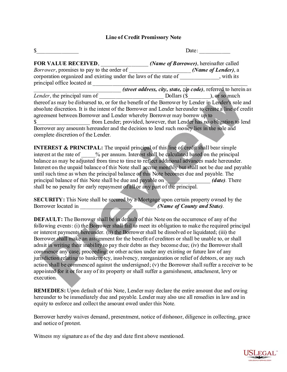
This form is used when the Parties agree and shall contribute all proprietary seismic data and all non-proprietary seismic data affecting the Contract Area in its possession as of the effective date of this Agreement, to the extent the data is not restricted by confidentiality or licensing agreements with third parties. It is specifically understood and agreed that each Party has the right to sell, trade, and/or otherwise market seismic data involving the Contract Area which was in its possession prior to the effective date of this Agreement, and the benefits and advantages, including monetary consideration, which it receives as a result of those activities shall be the sole property of the party who owns the data.

Connecticut Seismic Data and Operations are essential components of seismic research and monitoring in the state of Connecticut, USA. This field focuses on collecting, analyzing, and interpreting seismic data to gain deeper insight into the tectonic activity, earthquake occurrences, and subsurface structures within the region. It plays a crucial role in understanding the geology and seismic hazards of Connecticut which subsequently aids in emergency preparedness, infrastructure development, and public safety. Connecticut Seismic Data primarily refers to the information obtained from various seismic instruments strategically placed throughout the state. These instruments, such as seismographs and accelerometers, continuously record ground motion caused by seismic waves generated by earthquakes or human activities such as explosions or mining operations. The collected data provides detailed records of the amplitude, frequency, and duration of seismic events, aiding in the assessment of earthquake characteristics, fault systems, and source regions. Seismic Operations in Connecticut encompass a range of activities associated with the collection, analysis, and interpretation of seismic data. These operations involve the deployment and maintenance of seismic monitoring stations, data acquisition systems, and data processing techniques. Highly trained seismologists, geophysicists, and technicians undertake tasks like instrument calibration, data quality control, and interpretation of seismic records to extract valuable insights. Different types of Connecticut Seismic Data and Operations can be distinguished based on their specific objectives and focus areas. These include: 1. Earthquake Monitoring: This involves continuous monitoring of seismic activities to detect and locate earthquakes within the region accurately. It includes the real-time monitoring of ground vibrations and the rapid issuance of earthquake alerts to facilitate emergency response measures. 2. Seismic Hazard Assessment: By analyzing historical seismic data and conducting geological studies, experts can assess the potential seismic hazards in Connecticut. This evaluation helps determine the probability of future earthquakes, identify active faults, and estimate ground shaking intensities in different parts of the state. 3. Geotechnical Investigations: Seismic operations are utilized to investigate subsurface conditions and evaluate the geotechnical properties of the soil and rocks underlying Connecticut. This information is crucial for designing buildings, bridges, and other infrastructure to withstand seismic forces. 4. Research and Scientific Studies: Seismic data and operations support in-depth research on various geological phenomena, such as stress accumulation along fault lines, seismic wave propagation, and tomography. These studies contribute to advancing our understanding of the region's geology, seismology, and earthquake dynamics. In conclusion, Connecticut Seismic Data and Operations involve the systematic collection, analysis, and interpretation of seismic data to enhance our understanding of earthquakes and the geological features of the region. They play a pivotal role in earthquake monitoring, hazard assessment, geotechnical investigations, and scientific research.

How to fill out Connecticut Seismic Data And Operations?

It is possible to invest hrs on-line looking for the lawful file template that suits the federal and state needs you require. US Legal Forms provides a huge number of lawful forms which are evaluated by professionals. It is simple to acquire or printing the Connecticut Seismic Data and Operations from my services.

If you already possess a US Legal Forms accounts, you can log in and click on the Download key. After that, you can total, edit, printing, or indication the Connecticut Seismic Data and Operations. Every lawful file template you acquire is your own for a long time. To get one more version associated with a obtained form, go to the My Forms tab and click on the corresponding key.

If you are using the US Legal Forms website for the first time, follow the straightforward instructions listed below:

  • Initial, ensure that you have chosen the correct file template for that area/area of your liking. Read the form outline to ensure you have chosen the proper form. If offered, utilize the Review key to search through the file template too.
  • If you want to get one more model in the form, utilize the Lookup industry to obtain the template that suits you and needs.
  • When you have located the template you need, click on Get now to continue.
  • Find the costs strategy you need, type in your credentials, and sign up for an account on US Legal Forms.
  • Full the deal. You can utilize your credit card or PayPal accounts to purchase the lawful form.
  • Find the formatting in the file and acquire it for your product.
  • Make modifications for your file if required. It is possible to total, edit and indication and printing Connecticut Seismic Data and Operations.

Download and printing a huge number of file layouts while using US Legal Forms site, that offers the largest selection of lawful forms. Use professional and express-particular layouts to take on your company or specific requires.

Form popularity

FAQ

While earthquakes are an unusual occurrence in Connecticut, they have been known to occur, especially in the East Haddam and now Plainfield areas. While a severe earthquake is considered unlikely in Connecticut, geologists cannot predict with certainty, when, where or how severe, an earthquake may occur.

While earthquakes are an unusual occurrence in Connecticut, they have been known to occur, especially in the East Haddam and now Plainfield areas. While a severe earthquake is considered unlikely in Connecticut, geologists cannot predict with certainty, when, where or how severe, an earthquake may occur.

The last notable earthquake reported in Connecticut was a 1.4 magnitude earthquake that shook up the area surrounding Cos Cob in January of 2022.

The last notable earthquake reported in Connecticut was a 1.4 magnitude earthquake that shook up the area surrounding Cos Cob in January of 2022.

Although earthquakes have been centered in a number of different parts of Connecticut, the state is best known for its seismic activity near the little town of Moodus. The word Moodus comes from the local Native Americans, who called the locality Machemoodus, which means ?Place of Noises?.

But the geology of the state is actually quite complex, owing to lots of tectonic activity in its prehistoric past. Plainfield is not far from an ancient fault called the Lake Char-Honey Hill line that formed when the Pangea supercontinent was assembled about 400 million years ago.

In the area you have selected (Connecticut) earthquake hazard is classified as low ing to the information that is currently available. This means that there is a 2% chance of potentially-damaging earthquake shaking in your project area in the next 50 years.

On , the largest earthquake to shake Connecticut took place in Moodus. Called ?Machimoodus,? meaning the place of noises by Native Americans, Moodus and the area around East Haddam has long been known for earthquakes.

More info

Oct 1, 2022 — (Amd) 101.2 Scope. The provisions of this code shall apply to the construction, alteration, movement, enlargement, replacement, repair ... This manual provides an overview of the geotechnical design process, from planning through the completed construction of a project. The manual is intended to be ...Nov 8, 2016 — What is a seismic survey? Seismic surveys use acoustic waves to ... To ensure the safety and economic viability of fishing operations, survey ... Survey lines along which seismic reflection data were collected in 2012 by the U.S. Geological Survey in the Connecticut River during field activity 2012-024-FA ... describes in detail how to complete the Level 1 Data Collection Form, and ... • Selection of the Data Collection Form based on the seismic hazard and review and ... by A Backscatter — Data Collection and Processing · Survey Operations · Bathymetry · Acoustic Backscatter · Seismic-Reflection Profiling · Ground Validation. Surficial Sediment Samples ... MASW survey and data processing services for Vs30m, seismic site classification. Use this page to find local disaster recovery centers, flood maps, fact sheets, FEMA contacts, jobs and other resources. Connecticut. Jul 6, 2023 — CSP records collected in the Connecticut River near Hartford, Connecticut ... The seismic record and boring data indicate that under the channel, ... If the customer then requests Seismic to correct, amend, or delete the data in Seismic's possession or control, we will respond to their request promptly. A.

Trusted and secure by over 3 million people of the world’s leading companies

Connecticut Seismic Data and Operations