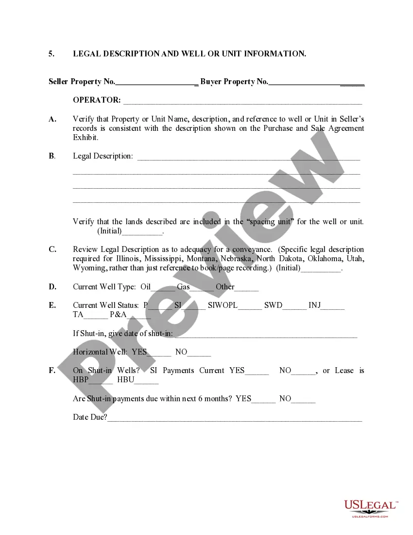
Florida Legal Description is a precise and detailed depiction of a property's boundaries, often used in real estate transactions. It serves as an official record and identification of a specific piece of land within the jurisdiction of Florida. The legal description typically includes information such as the lot of number, block number, subdivision, and county where the property is located. There are several types of Florida Legal Descriptions, including: 1. Metes and Bounds: This type of legal description utilizes physical landmarks, such as trees, rocks, and specific measurements (metes) to describe the boundaries of a property. It involves starting at a designated point of beginning and then tracing the property's boundaries in a series of angles and distances. 2. Government Rectangular Survey System: This legal description system is commonly used in areas where land divisions are based on a grid. The survey system divides the land into townships, ranges, and sections, allowing for precise identification of a property's location and boundaries. It utilizes a combination of meridians, baselines, and measured distances to establish the legal boundaries. 3. Plat-based: In cases where land is located within a formally recorded subdivision, a plat-based legal description is used. The legal description refers to a specific lot or parcel as identified on the recorded plat, which provides precise measurements and markings of each individual lot within the subdivision. Well or Unit Information, on the other hand, pertains to the drilling of oil and gas wells in Florida. In oil and gas exploration and production, a well is typically drilled to extract or explore for petroleum resources beneath the surface. In some cases, multiple wells may be grouped together under a single unit known as a well unit. Well or Unit Information in Florida includes various details related to the drilling and operation of wells, such as: 1. Well Location: This provides specific geographical coordinates or legal descriptions to identify the precise location of each well in correlation to the surrounding land and geological formations. 2. Well Depth: Refers to the vertical distance in feet or meters from the surface to the bottom of the drilled well. Well depth is crucial for determining the potential production capacity and targeting specific geological formations. 3. Well Permits: In Florida, well drilling requires a permit issued by the relevant regulatory authority. Well or Unit Information includes the permit numbers and any associated documentation, ensuring compliance with local regulations. 4. Well Operators: The information identifies the individuals or companies responsible for drilling and operating the well. It includes contact details, licenses, and certifications of the operators involved. 5. Well Production: This valuable information indicates the amount of oil, gas, or other hydrocarbons produced by a particular well over time. It helps evaluate the commercial viability and profitability of the well. Understanding Florida Legal Description and Well or Unit Information is crucial for real estate professionals, land developers, and oil and gas industry stakeholders. By referring to accurate and comprehensive legal descriptions, potential disputes or confusion regarding property boundaries can be avoided. Similarly, well or unit information ensures efficient and compliant drilling operations while enabling stakeholders to make informed decisions based on production data.
Florida Legal Description and Well or Unit Information
Description

How to fill out Florida Legal Description And Well Or Unit Information?
It is possible to commit hrs online searching for the authorized file web template that fits the federal and state demands you require. US Legal Forms offers thousands of authorized types which can be reviewed by pros. You can actually download or produce the Florida Legal Description and Well or Unit Information from my assistance.
If you have a US Legal Forms account, you can log in and click on the Acquire switch. Next, you can complete, change, produce, or sign the Florida Legal Description and Well or Unit Information. Each and every authorized file web template you buy is your own property permanently. To acquire another duplicate associated with a purchased develop, proceed to the My Forms tab and click on the corresponding switch.
If you are using the US Legal Forms internet site for the first time, keep to the easy recommendations beneath:
- First, make sure that you have selected the proper file web template for the state/city that you pick. Look at the develop description to make sure you have picked out the appropriate develop. If readily available, make use of the Review switch to look throughout the file web template too.
- If you would like locate another model from the develop, make use of the Research discipline to discover the web template that meets your needs and demands.
- Upon having discovered the web template you desire, click Purchase now to move forward.
- Pick the pricing prepare you desire, type your qualifications, and register for an account on US Legal Forms.
- Full the deal. You can use your credit card or PayPal account to purchase the authorized develop.
- Pick the formatting from the file and download it to your system.
- Make modifications to your file if needed. It is possible to complete, change and sign and produce Florida Legal Description and Well or Unit Information.
Acquire and produce thousands of file layouts utilizing the US Legal Forms website, which provides the most important collection of authorized types. Use skilled and status-distinct layouts to tackle your company or individual demands.
Form popularity
FAQ
Before you sit down to read your legal description there are a few things you should know?. There are three different formats of legal descriptions: rectangular survey system ? also known as sectional ground, lot and block, and metes and bounds.
A metes and bounds description, which means distance and direction, begins and ends at a landmark called the point of beginning (POB). The property is measured and described in a point of direction from a starting point using angles, distance, directions, and landmarks.
A legal description is a written way to describe a piece of property that is recognized by law and is sufficient to locate the property without oral testimony. Generally included with the legal description is a sketch that illustrates the written description with bearing lines and distances.
Fractional Designation: The most common form seen. A fractional designation uses rectangular surveying to correctly describe the land in sections. Metes and Bounds: This form of description uses references, such as streets and rivers to identify each point of the property (north, south, east, and west).
A lot and block description will simply list the lot number, the block number, the subdivision, the county, and the state. So, a description might say ?Lot two, block four, Oak Hills Estate, Johnson County, Kansas? and that's all. That would be the legal description.
A legal description provides legal evidence of the boundaries and allows a surveyor to accurately determine property lines at a later time. This is incredibly useful and necessary during real estate transactions or disputes. The description will typically appear on sales contracts and the property deed.
The lot and block legal description is the simplest to read by the average person. It is often used in planned land subdivisions and contains: The individual lot. The block where it is located.
The property description used in deeds and other land documents will refer to the name of the subdivision and the lot number. For example: "Lot 42, Block 3, of North Lakes Subdivision #1, ing to map or plat thereof as recorded in Plat Book 62, Page 9, of the Public Records of Orange County, Florida."