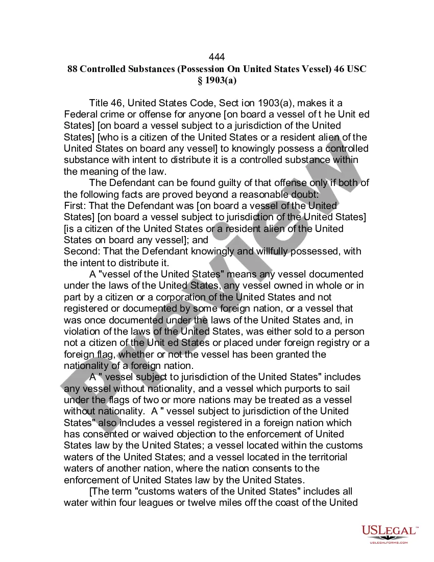
This form is used when the Parties agree and shall contribute all proprietary seismic data and all non-proprietary seismic data affecting the Contract Area in its possession as of the effective date of this Agreement, to the extent the data is not restricted by confidentiality or licensing agreements with third parties. It is specifically understood and agreed that each Party has the right to sell, trade, and/or otherwise market seismic data involving the Contract Area which was in its possession prior to the effective date of this Agreement, and the benefits and advantages, including monetary consideration, which it receives as a result of those activities shall be the sole property of the party who owns the data.
Florida Seismic Data and Operations is a comprehensive system that focuses on the analysis, collection, and interpretation of seismic data in the state of Florida. Seismic data refers to the measurements and recordings of seismic waves that occur naturally or due to man-made activities, providing valuable insights into the Earth's subsurface structure and the behavior of rocks and fluids within the region. Florida Seismic Data and Operations aim to monitor and understand the occurrence of earthquakes, the geological characteristics of the state, and potential sources of hazards associated with seismic activities. By utilizing state-of-the-art equipment and advanced analysis techniques, the system enables scientists and geologists to assess the risks, enhance public safety, and contribute to urban planning and infrastructure development. Various types of Florida Seismic Data and Operations can be identified, each serving specific purposes and providing unique information. These can include: 1. Seismic Monitoring: This type of operation involves the continuous recording of seismic events using a network of seismometers strategically placed throughout Florida. This network helps detect, locate, and determine the magnitude of earthquakes accurately. It also enables the identification of potential earthquake-prone areas and assists in the creation of seismic hazard maps. 2. Seismic Hazard Assessment: This aspect focuses on analyzing the collected seismic data to evaluate the potential hazard level associated with different areas within Florida. Experts use advanced algorithms and models to quantify the likelihood of specific levels of ground shaking. By assessing the potential impact of earthquakes on infrastructure and population, authorities can develop appropriate mitigation measures and building codes to maximize safety. 3. Geological and Geophysical Research: Florida Seismic Data and Operations also contribute to ongoing geological and geophysical research in the state. Seismic data is invaluable in studying the subsurface structure, fault systems, and geologic history. It provides insights into underground fluid movements, including freshwater and hydrocarbon reservoirs, that are crucial for resource exploration and management. 4. Induced Basicity Monitoring: This specific operation focuses on monitoring and analyzing seismic events triggered by human activities, such as oil and gas extraction or geothermal energy production. By understanding the relationship between industrial processes and induced earthquakes, regulatory authorities can establish guidelines to mitigate potential risks and ensure sustainable resource development. Overall, Florida Seismic Data and Operations play a vital role in understanding the seismic behavior of the state. By collecting and analyzing relevant data, geoscientists can gain valuable insights into the geological processes, identify potential hazards, and contribute to a safer and more informed decision-making process in various fields, including urban planning, infrastructure development, and resource management.
Florida Seismic Data and Operations is a comprehensive system that focuses on the analysis, collection, and interpretation of seismic data in the state of Florida. Seismic data refers to the measurements and recordings of seismic waves that occur naturally or due to man-made activities, providing valuable insights into the Earth's subsurface structure and the behavior of rocks and fluids within the region. Florida Seismic Data and Operations aim to monitor and understand the occurrence of earthquakes, the geological characteristics of the state, and potential sources of hazards associated with seismic activities. By utilizing state-of-the-art equipment and advanced analysis techniques, the system enables scientists and geologists to assess the risks, enhance public safety, and contribute to urban planning and infrastructure development. Various types of Florida Seismic Data and Operations can be identified, each serving specific purposes and providing unique information. These can include: 1. Seismic Monitoring: This type of operation involves the continuous recording of seismic events using a network of seismometers strategically placed throughout Florida. This network helps detect, locate, and determine the magnitude of earthquakes accurately. It also enables the identification of potential earthquake-prone areas and assists in the creation of seismic hazard maps. 2. Seismic Hazard Assessment: This aspect focuses on analyzing the collected seismic data to evaluate the potential hazard level associated with different areas within Florida. Experts use advanced algorithms and models to quantify the likelihood of specific levels of ground shaking. By assessing the potential impact of earthquakes on infrastructure and population, authorities can develop appropriate mitigation measures and building codes to maximize safety. 3. Geological and Geophysical Research: Florida Seismic Data and Operations also contribute to ongoing geological and geophysical research in the state. Seismic data is invaluable in studying the subsurface structure, fault systems, and geologic history. It provides insights into underground fluid movements, including freshwater and hydrocarbon reservoirs, that are crucial for resource exploration and management. 4. Induced Basicity Monitoring: This specific operation focuses on monitoring and analyzing seismic events triggered by human activities, such as oil and gas extraction or geothermal energy production. By understanding the relationship between industrial processes and induced earthquakes, regulatory authorities can establish guidelines to mitigate potential risks and ensure sustainable resource development. Overall, Florida Seismic Data and Operations play a vital role in understanding the seismic behavior of the state. By collecting and analyzing relevant data, geoscientists can gain valuable insights into the geological processes, identify potential hazards, and contribute to a safer and more informed decision-making process in various fields, including urban planning, infrastructure development, and resource management.