Georgia Geoscience Operations on the Contract Area

State:
Multi-State
Control #:
US-OG-705
Format:
Word; 
Rich Text
Instant download

Description

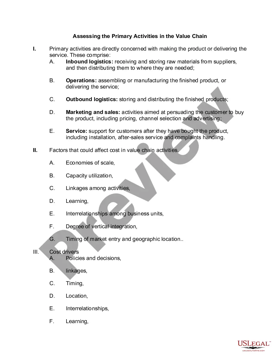
This form provides that any Party may propose that geoscience operations be conducted on the Contract Area lands. The Party wishing to conduct geoscience operations shall furnish the other Parties with an information notice which generally describes the proposed geoscience operation.

Georgia Geoscience Operations on the Contract Area involve a comprehensive range of geological and geophysical activities conducted in the designated area as part of a contractual agreement. These operations play a crucial role in assessing and understanding the geological attributes and potential of the region, aiding in the exploration and development of natural resources like oil, gas, minerals, and groundwater. By utilizing various scientific techniques and technologies, Georgia Geoscience Operations provide valuable insights into the subsurface characteristics, enabling informed decision-making processes concerning resource extraction and environmental planning. The Georgia Geoscience Operations on the Contract Area encompass several key activities, such as: 1. Geological Mapping: This involves detailed surveys and mapping of the geological formations present in the contract area. Geoscientists examine rock types, structures, and their spatial distribution, providing a comprehensive understanding of the area's geology, including its history, composition, and potential resource reservoirs. 2. Geophysical Surveys: Geophysical surveys employ a diverse range of methods to investigate subsurface properties. It includes techniques like seismic surveys, where sound waves are sent into the ground and their reflections are analyzed to determine the presence of rock layers, faults, and potential hydrocarbon reservoirs. Magnetic and gravity surveys are also conducted to identify variations in the Earth's magnetic and gravitational fields, helping locate subsurface mineral deposits. 3. Geochemical Analysis: Geochemical analysis involves collecting and analyzing rock, soil, and water samples from the contract area. These samples are used to evaluate the chemical composition, presence of valuable minerals, and potential contamination risks, aiding in environmental impact assessments and resource exploration. 4. Geotechnical Investigations: Geotechnical investigations assess the physical properties of soil and rock materials to determine their stability and suitability for construction projects. This is vital for engineering works such as building foundations, road construction, and infrastructure development in the contract area. 5. Hydro geological Studies: These studies focus on evaluating the quantity, quality, and movement of groundwater resources in the contract area. By analyzing aquifer characteristics and conducting well tests, geoscientists aid in the sustainable management and utilization of water resources. 6. Environmental Monitoring: Geoscience operations also involve continuous monitoring of environmental factors, such as air quality, water quality, and land degradation, to ensure compliance with regulatory standards. This helps to minimize any adverse impacts resulting from resource development activities. Overall, Georgia Geoscience Operations on the Contract Area offer crucial insights into the geology and potential of the region for resource extraction and sustainable development. By employing diverse techniques and methodologies, geoscientists contribute to informed decision-making processes, mitigating risks, and maximizing the benefits associated with natural resource exploration and utilization.

Georgia Geoscience Operations on the Contract Area involve a comprehensive range of geological and geophysical activities conducted in the designated area as part of a contractual agreement. These operations play a crucial role in assessing and understanding the geological attributes and potential of the region, aiding in the exploration and development of natural resources like oil, gas, minerals, and groundwater. By utilizing various scientific techniques and technologies, Georgia Geoscience Operations provide valuable insights into the subsurface characteristics, enabling informed decision-making processes concerning resource extraction and environmental planning. The Georgia Geoscience Operations on the Contract Area encompass several key activities, such as: 1. Geological Mapping: This involves detailed surveys and mapping of the geological formations present in the contract area. Geoscientists examine rock types, structures, and their spatial distribution, providing a comprehensive understanding of the area's geology, including its history, composition, and potential resource reservoirs. 2. Geophysical Surveys: Geophysical surveys employ a diverse range of methods to investigate subsurface properties. It includes techniques like seismic surveys, where sound waves are sent into the ground and their reflections are analyzed to determine the presence of rock layers, faults, and potential hydrocarbon reservoirs. Magnetic and gravity surveys are also conducted to identify variations in the Earth's magnetic and gravitational fields, helping locate subsurface mineral deposits. 3. Geochemical Analysis: Geochemical analysis involves collecting and analyzing rock, soil, and water samples from the contract area. These samples are used to evaluate the chemical composition, presence of valuable minerals, and potential contamination risks, aiding in environmental impact assessments and resource exploration. 4. Geotechnical Investigations: Geotechnical investigations assess the physical properties of soil and rock materials to determine their stability and suitability for construction projects. This is vital for engineering works such as building foundations, road construction, and infrastructure development in the contract area. 5. Hydro geological Studies: These studies focus on evaluating the quantity, quality, and movement of groundwater resources in the contract area. By analyzing aquifer characteristics and conducting well tests, geoscientists aid in the sustainable management and utilization of water resources. 6. Environmental Monitoring: Geoscience operations also involve continuous monitoring of environmental factors, such as air quality, water quality, and land degradation, to ensure compliance with regulatory standards. This helps to minimize any adverse impacts resulting from resource development activities. Overall, Georgia Geoscience Operations on the Contract Area offer crucial insights into the geology and potential of the region for resource extraction and sustainable development. By employing diverse techniques and methodologies, geoscientists contribute to informed decision-making processes, mitigating risks, and maximizing the benefits associated with natural resource exploration and utilization.

Free preview
  • Form preview
  • Form preview
  • Form preview

How to fill out Georgia Geoscience Operations On The Contract Area?

You can spend hours online looking for the authorized document template that meets the federal and state needs you will need. US Legal Forms supplies a large number of authorized kinds which are evaluated by experts. It is simple to down load or print out the Georgia Geoscience Operations on the Contract Area from your service.

If you already have a US Legal Forms account, you are able to log in and then click the Obtain button. Afterward, you are able to comprehensive, edit, print out, or indication the Georgia Geoscience Operations on the Contract Area. Every authorized document template you buy is your own property eternally. To get one more copy associated with a obtained kind, go to the My Forms tab and then click the corresponding button.

If you are using the US Legal Forms web site for the first time, stick to the basic recommendations under:

  • Very first, ensure that you have selected the best document template for your state/town of your choosing. Look at the kind explanation to ensure you have picked out the correct kind. If available, make use of the Preview button to search through the document template also.
  • In order to get one more variation of the kind, make use of the Research area to get the template that meets your requirements and needs.
  • Upon having found the template you desire, click on Acquire now to carry on.
  • Pick the pricing strategy you desire, key in your references, and sign up for your account on US Legal Forms.
  • Total the financial transaction. You should use your Visa or Mastercard or PayPal account to purchase the authorized kind.
  • Pick the structure of the document and down load it to your gadget.
  • Make changes to your document if possible. You can comprehensive, edit and indication and print out Georgia Geoscience Operations on the Contract Area.

Obtain and print out a large number of document web templates while using US Legal Forms website, which provides the largest selection of authorized kinds. Use expert and state-distinct web templates to take on your business or specific demands.

Trusted and secure by over 3 million people of the world’s leading companies

Georgia Geoscience Operations on the Contract Area