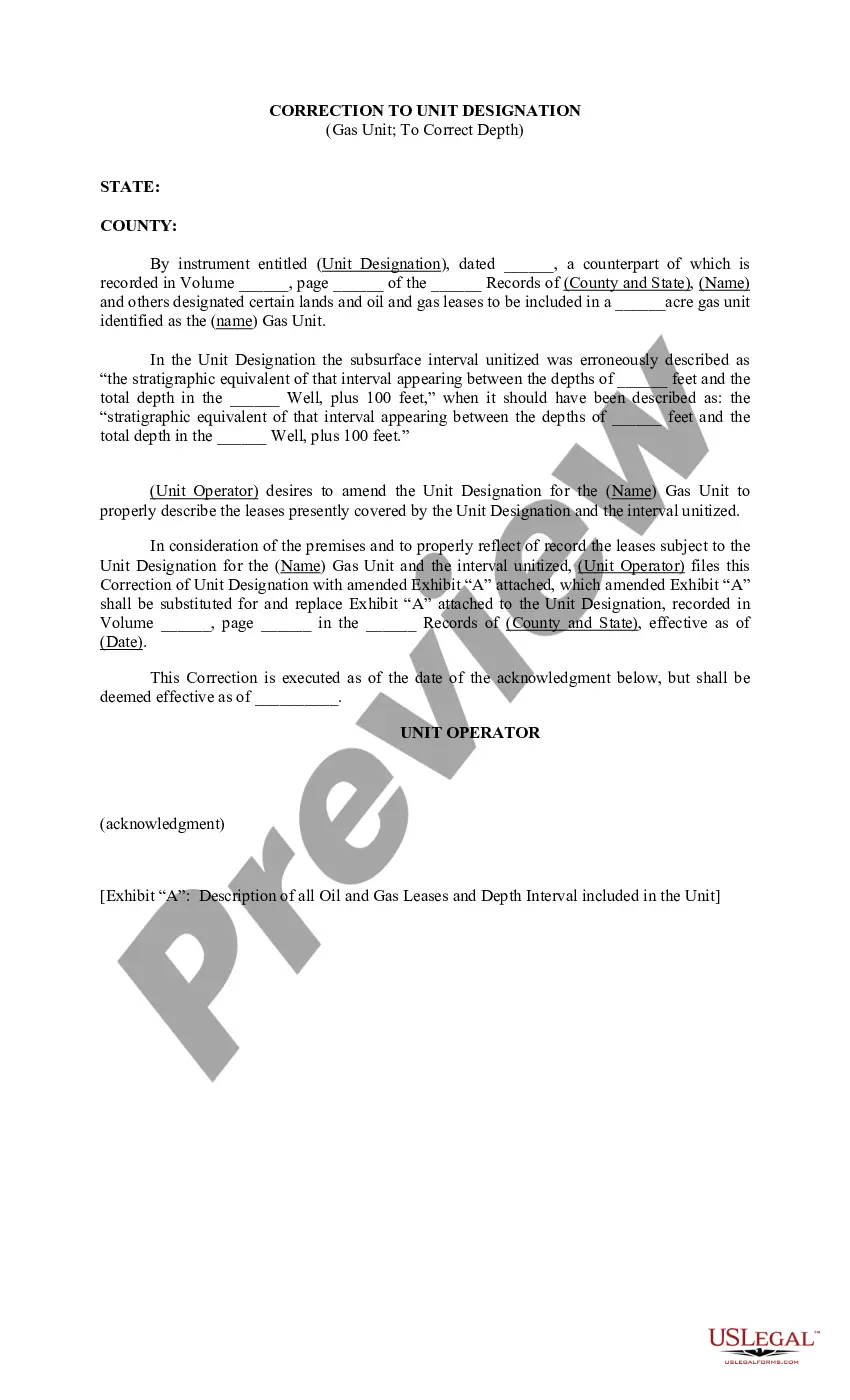
Idaho Correction to Unit Designation to Correct Depth refers to the process of rectifying errors in measurement of depth in geographical units in the state of Idaho. This correction is essential to ensure accurate and precise data for various purposes such as land management, exploration, infrastructure planning, and environmental studies. By using proper techniques and equipment, the Idaho Correction to Unit Designation to Correct Depth helps to maintain consistency and reliability in depth measurements. There are different types of Idaho Correction to Unit Designation to Correct Depth, including: 1. Geodetic Correction: This type of correction involves adjusting depth measurements based on geodetic survey data. Geodetic surveys provide accurate information about the Earth's shape, which helps in correcting depth measurements to align with the reference datum. 2. Sea Level Correction: Sea level correction is necessary when depth measurements are referenced to mean sea level. As Idaho is a landlocked state, this correction ensures that the depth measurements are comparable to those taken at sea or oceanic regions. 3. Topographic Correction: Topographic correction involves accounting for the variations in terrain and surface elevation. It corrects depth measurements by considering the differences in slope, gradient, and relief, which affect the accuracy of depth data. 4. Datum Conversion: When depth measurements are recorded using different reference data, datum conversion correction is required to standardize the data. This ensures that depth measurements from different sources can be compared and analyzed accurately. 5. Instrument Error Correction: Instrument error correction involves compensating for any systematic errors introduced by measurement instruments. It accounts for errors caused by instrument calibration, systematic bias, or inconsistencies in measurements. The Idaho Correction to Unit Designation to Correct Depth plays a crucial role in maintaining the integrity and reliability of depth measurements across various geographical units in the state. It ensures accurate representation of depth information, allowing for informed decision-making and effective management of Idaho's natural resources.
Idaho Correction to Unit Designation to Correct Depth
Description
How to fill out Idaho Correction To Unit Designation To Correct Depth?
If you have to total, down load, or produce authorized papers layouts, use US Legal Forms, the greatest collection of authorized types, that can be found on-line. Take advantage of the site`s simple and practical lookup to obtain the documents you will need. A variety of layouts for company and personal purposes are categorized by groups and says, or keywords and phrases. Use US Legal Forms to obtain the Idaho Correction to Unit Designation to Correct Depth in just a number of mouse clicks.
If you are currently a US Legal Forms client, log in to the bank account and then click the Obtain key to find the Idaho Correction to Unit Designation to Correct Depth. You can even accessibility types you formerly acquired from the My Forms tab of your respective bank account.
If you are using US Legal Forms the very first time, refer to the instructions below:
- Step 1. Be sure you have selected the shape for that proper area/nation.
- Step 2. Utilize the Review option to examine the form`s content material. Don`t forget to read through the explanation.
- Step 3. If you are unhappy together with the type, make use of the Lookup field towards the top of the display screen to get other versions in the authorized type design.
- Step 4. After you have located the shape you will need, click on the Buy now key. Choose the pricing prepare you like and put your accreditations to register to have an bank account.
- Step 5. Procedure the transaction. You should use your charge card or PayPal bank account to perform the transaction.
- Step 6. Select the file format in the authorized type and down load it on your system.
- Step 7. Full, revise and produce or indication the Idaho Correction to Unit Designation to Correct Depth.
Each authorized papers design you purchase is your own property forever. You have acces to each and every type you acquired with your acccount. Click on the My Forms portion and decide on a type to produce or down load once again.
Remain competitive and down load, and produce the Idaho Correction to Unit Designation to Correct Depth with US Legal Forms. There are many skilled and state-particular types you can utilize to your company or personal requirements.