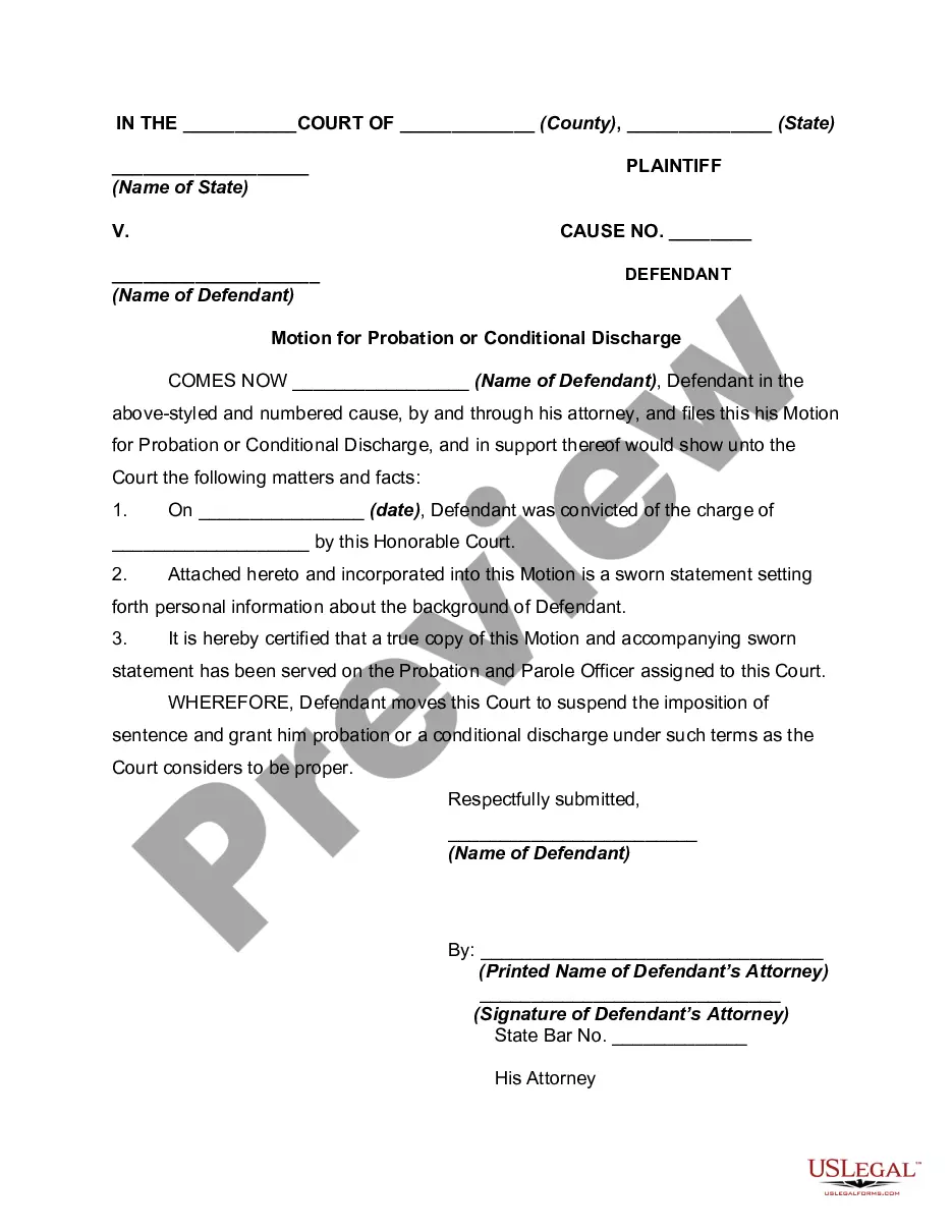
This form is used when the Parties agree and shall contribute all proprietary seismic data and all non-proprietary seismic data affecting the Contract Area in its possession as of the effective date of this Agreement, to the extent the data is not restricted by confidentiality or licensing agreements with third parties. It is specifically understood and agreed that each Party has the right to sell, trade, and/or otherwise market seismic data involving the Contract Area which was in its possession prior to the effective date of this Agreement, and the benefits and advantages, including monetary consideration, which it receives as a result of those activities shall be the sole property of the party who owns the data.
Indiana Seismic Data and Operations is a comprehensive system that gathers and analyzes seismic data in the state of Indiana. This system plays a crucial role in monitoring and studying the occurrence of earthquakes and other seismic activities across the region. By employing the latest technologies and methods, Indiana Seismic Data and Operations ensures accurate and reliable data collection, which is essential for evaluating seismic hazards, improving disaster preparedness, and understanding the geological aspects of the state. One key component of Indiana Seismic Data and Operations is the network of seismic monitoring stations strategically placed throughout the state. These stations are equipped with state-of-the-art seismometers, which are sensitive instruments capable of detecting even the slightest ground motion caused by seismic events. The network continuously collects data in real-time, enabling prompt detection and analysis of seismic activities. The collected data from the monitoring stations is then transmitted to a central data processing and analysis center where it undergoes a series of sophisticated procedures. This center is staffed by a team of skilled seismologists and geophysicists who employ advanced algorithms and techniques to extract valuable information from the raw seismic data. These analyses include determining the location, magnitude, and focal mechanisms of earthquakes, as well as studying the basicity patterns and trends within Indiana. The Indiana Seismic Data and Operations system also comprises a comprehensive earthquake catalog, which is continually updated with the latest seismic event information. This catalog serves as an important reference for researchers, policymakers, and emergency response agencies to assess historical basicity, identify potential earthquake-prone areas, and evaluate the effectiveness of seismic hazard mitigation measures. In addition to earthquake monitoring, Indiana Seismic Data and Operations also oversees various research initiatives focused on understanding the geological and tectonic characteristics of the region. This involves studying the underlying fault systems, exploring the relationship between seismic activities and geological structures, and investigating potential sources of basicity in Indiana. Overall, the Indiana Seismic Data and Operations system plays a crucial role in mitigating the risks associated with seismic events in Indiana. Its extensive monitoring network, advanced data processing capabilities, and research endeavors contribute to fostering a safer environment for residents and promoting the overall understanding of basicity within the state. Different types of Indiana Seismic Data and Operations include: 1. Real-time Seismic Monitoring: This type focuses on the continuous observation and recording of ground motion in real-time using a network of seismic monitoring stations. 2. Seismic Data Processing and Analysis: This type involves the conversion of raw seismic data into meaningful information through various computational procedures and advanced algorithms. 3. Seismic Hazard Assessment: This type encompasses the evaluation of potential risks and hazards posed by seismic activities, including the identification of earthquake-prone areas and the estimation of ground shaking intensities. 4. Geological and Tectonic Studies: This type focuses on investigating the geological and tectonic aspects of Indiana, such as fault systems, subsurface structures, and their association with basicity, to gain a comprehensive understanding of the region's seismic behavior. 5. Research Initiatives: This type involves ongoing research projects that aim to expand knowledge about seismic processes in Indiana, improve data analysis techniques, and develop more accurate earthquake forecasting and early warning systems.