Maryland Exhibit A Legal Description of Lands
Description


How to fill out Maryland Exhibit A Legal Description Of Lands?
You are welcome to the largest legal files library, US Legal Forms. Here you will find any example including Maryland Exhibit A Legal Description of Lands forms and download them (as many of them as you wish/need). Prepare official papers in just a several hours, instead of days or even weeks, without having to spend an arm and a leg with an lawyer or attorney. Get the state-specific form in a few clicks and be confident knowing that it was drafted by our qualified legal professionals.
If you’re already a subscribed user, just log in to your account and click Download next to the Maryland Exhibit A Legal Description of Lands you want. Because US Legal Forms is online solution, you’ll generally have access to your saved forms, no matter the device you’re using. See them inside the My Forms tab.
If you don't have an account yet, just what are you waiting for? Check out our guidelines listed below to get started:
- If this is a state-specific sample, check out its validity in the state where you live.
- View the description (if readily available) to understand if it’s the proper example.
- See much more content with the Preview function.
- If the example matches all your needs, just click Buy Now.
- To create an account, select a pricing plan.
- Use a card or PayPal account to sign up.
- Save the document in the format you need (Word or PDF).
- Print out the document and complete it with your/your business’s info.
After you’ve filled out the Maryland Exhibit A Legal Description of Lands, send it to your attorney for verification. It’s an additional step but a necessary one for being confident you’re fully covered. Become a member of US Legal Forms now and get access to a mass amount of reusable examples.
Form popularity
FAQ
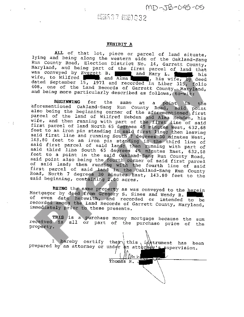
A metes-and-bounds description begins from a reference point called a point of beginning (POB). From the point of beginning, the legal description gives the direction and the distances of the boundaries.Compass bearings are used to describe the direction of the boundary lines.
The legal description of a parcel of land that is measured in distances, angles, and directions. A surveyor uses directions and distances from physical monuments to define and describe the boundaries of the parcel of land.
A legal description is one that is legally sufficient to transfer describe the property. Using the most recent deed to the property is usually the best way to ensure that the current owner's interest passes to the new owner.
There are five types of legal descriptions that have been developed to achieve greater accuracy and precision in identifying land and land rights: 1) the United States Public Land Survey System (USPLSS), sometimes referred to as the rectangular or quadrangular survey system; 2) descriptions referring to recorded
A metes and bounds legal description starts from a point of beginning, then traces the outline of the property's boundary lines until there is closure in the legal description. Natural monuments and artificial monuments can both be used as metes and bounds. For example, rivers, roads, trees, etc.
In the realm of legal land descriptions, there are many avenues used to describe a parcel of land.The seven major description systems are: (1) metes and bounds; (2) lot and block; (3) portion of another parcel("ly"); (4) legal subdivisions; (5) reference to a map, plat, or deed; (6) coordinates; and (7) strip.
Examples of metes and bounds landmarks include rivers, roads, stakes, or other such natural or manmade markers. Metes and bounds descriptions are typically used whenever land survey areas are irregularly sized and/or shaped, so that the boundaries of the property can be more clearly defined.
A legal description. Is a detailed way of describing a parcel of land for documents such as deeds and mortgages. Survey. The process by which boundaries are measured by calculating the dimensions and area to determine the exact location of a piece of land. You just studied 24 terms!
A metes and bounds description starts at a well-marked point of beginning (POB) and establishes the boundaries of the parcel by courses and metes (length in inches, feet, yards, miles) and bounds (directions based on landmarks, monuments, angles) and returns to the true point of beginning.