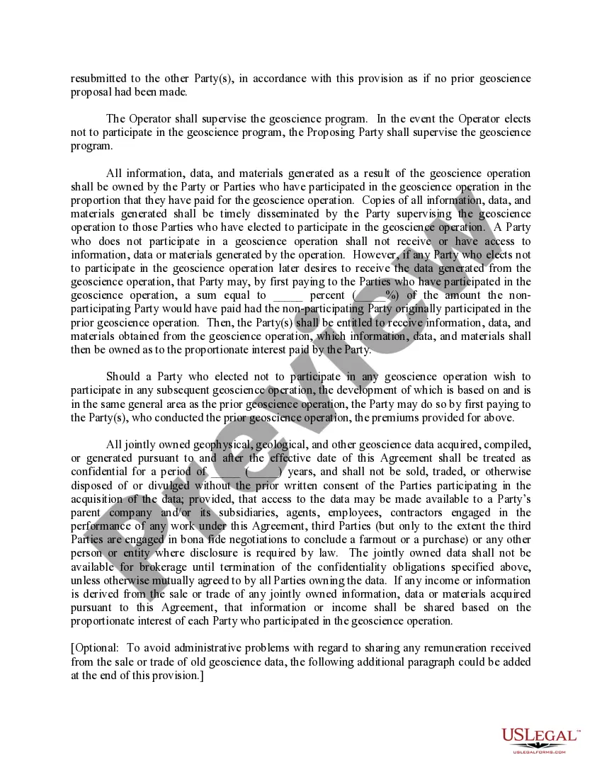
This form provides that any Party may propose that geoscience operations be conducted on the Contract Area lands. The Party wishing to conduct geoscience operations shall furnish the other Parties with an information notice which generally describes the proposed geoscience operation.
Maine Geoscience Operations on the Contract Area encompass a range of activities conducted in the state of Maine to explore, analyze, and assess its geological and geophysical characteristics. These operations play a crucial role in understanding the region's natural resources, geologic hazards, and potential for energy exploration and development. Keyword-rich content detailing the various types of Maine Geoscience Operations on the Contract Area may include: 1. Geological Surveys: Maine Geoscience Operations include comprehensive geological surveys to map the state’s bedrock geologysurgicalal deposits, and mineral resources. These surveys provide valuable insights into the geologic history, rock formations, and potential mineral deposits found within the contract area. 2. Geophysical Studies: Through the use of various geophysical techniques such as seismic surveys, electromagnetic surveys, and gravity and magnetic studies, geoscientists gather data to understand the subsurface structures, identify potential hydrocarbon reservoirs, and map the geological features of the contract area. 3. Geochemical Analysis: Maine Geoscience Operations involve analyzing the chemical composition of rocks, soils, and stream sediments to determine the presence of valuable minerals, assess soil fertility, and understand potential environmental impact factors. Geochemical analysis aids in identifying mineralization patterns and potential economic deposits. 4. Geological Hazards Assessment: Geoscientists also conduct assessments of geological hazards in the contract area, such as landslides, earthquakes, and coastal erosion. By analyzing historical geological events and mapping vulnerable areas, these operations help in developing strategies to mitigate and manage potential risks. 5. Petroleum Exploration: Maine's geoscience operations also include petroleum exploration efforts, primarily offshore. Seismic surveys and geological studies enable the identification of potential hydrocarbon reservoirs, evaluating their commercial viability for offshore oil and gas exploration and production. 6. Environmental Impact Assessments: Geoscience operations on the contract area encompass environmental impact assessments of potential projects. By examining the geological and hydrological systems, experts assess the potential impacts of development activities on the surrounding ecosystem, water sources, and human communities. 7. Resource Management and Conservation: Maine Geoscience Operations play a crucial role in managing the state's geological resources and implementing effective conservation strategies. By evaluating resource extraction practices, managing water resources, and promoting sustainable land use, these operations contribute to the long-term preservation and responsible utilization of Maine's natural resources. In summary, Maine Geoscience Operations on the Contract Area involve geological surveys, geophysical studies, geochemical analysis, geological hazards assessment, petroleum exploration, environmental impact assessments, and resource management. These operations help in understanding Maine's geological characteristics, identifying potential resources, managing risks, and ensuring sustainable development.Maine Geoscience Operations on the Contract Area encompass a range of activities conducted in the state of Maine to explore, analyze, and assess its geological and geophysical characteristics. These operations play a crucial role in understanding the region's natural resources, geologic hazards, and potential for energy exploration and development. Keyword-rich content detailing the various types of Maine Geoscience Operations on the Contract Area may include: 1. Geological Surveys: Maine Geoscience Operations include comprehensive geological surveys to map the state’s bedrock geologysurgicalal deposits, and mineral resources. These surveys provide valuable insights into the geologic history, rock formations, and potential mineral deposits found within the contract area. 2. Geophysical Studies: Through the use of various geophysical techniques such as seismic surveys, electromagnetic surveys, and gravity and magnetic studies, geoscientists gather data to understand the subsurface structures, identify potential hydrocarbon reservoirs, and map the geological features of the contract area. 3. Geochemical Analysis: Maine Geoscience Operations involve analyzing the chemical composition of rocks, soils, and stream sediments to determine the presence of valuable minerals, assess soil fertility, and understand potential environmental impact factors. Geochemical analysis aids in identifying mineralization patterns and potential economic deposits. 4. Geological Hazards Assessment: Geoscientists also conduct assessments of geological hazards in the contract area, such as landslides, earthquakes, and coastal erosion. By analyzing historical geological events and mapping vulnerable areas, these operations help in developing strategies to mitigate and manage potential risks. 5. Petroleum Exploration: Maine's geoscience operations also include petroleum exploration efforts, primarily offshore. Seismic surveys and geological studies enable the identification of potential hydrocarbon reservoirs, evaluating their commercial viability for offshore oil and gas exploration and production. 6. Environmental Impact Assessments: Geoscience operations on the contract area encompass environmental impact assessments of potential projects. By examining the geological and hydrological systems, experts assess the potential impacts of development activities on the surrounding ecosystem, water sources, and human communities. 7. Resource Management and Conservation: Maine Geoscience Operations play a crucial role in managing the state's geological resources and implementing effective conservation strategies. By evaluating resource extraction practices, managing water resources, and promoting sustainable land use, these operations contribute to the long-term preservation and responsible utilization of Maine's natural resources. In summary, Maine Geoscience Operations on the Contract Area involve geological surveys, geophysical studies, geochemical analysis, geological hazards assessment, petroleum exploration, environmental impact assessments, and resource management. These operations help in understanding Maine's geological characteristics, identifying potential resources, managing risks, and ensuring sustainable development.