Michigan Seismic Data and Operations

State:
Multi-State
Control #:
US-OG-720
Format:
Word; 
Rich Text
Instant download

Description

This form is used when the Parties agree and shall contribute all proprietary seismic data and all non-proprietary seismic data affecting the Contract Area in its possession as of the effective date of this Agreement, to the extent the data is not restricted by confidentiality or licensing agreements with third parties. It is specifically understood and agreed that each Party has the right to sell, trade, and/or otherwise market seismic data involving the Contract Area which was in its possession prior to the effective date of this Agreement, and the benefits and advantages, including monetary consideration, which it receives as a result of those activities shall be the sole property of the party who owns the data.

Michigan Seismic Data and Operations play a vital role in monitoring and understanding seismic activity in the state of Michigan. Seismic data refers to measurements and recordings of ground vibrations or seismic waves caused by natural or artificial sources, such as earthquakes, underground explosions, or even human activities like drilling. The Michigan Seismic Data and Operations primarily focus on collecting seismic data from various sources, analyzing and interpreting the data, and using it to assess and manage potential risks associated with seismic events. They operate a network of seismometers strategically placed throughout the state to accurately detect and measure ground motion. One crucial aspect of Michigan Seismic Data and Operations is earthquake monitoring. Earthquakes, although relatively rare in Michigan, do occur and can have significant consequences. By continuously monitoring seismic activities, experts can promptly alert the public and government authorities in case of an earthquake occurrence. This helps in devising efficient emergency response plans, ensuring public safety, and minimizing potential damage. Moreover, these operations also involve the identification of seismic hazards, studying ground vibrations caused by human activities, and assessing the impact of seismic events on infrastructure and buildings. This information plays a crucial role in designing and implementing appropriate building codes, regulations, and guidelines to ensure structural safety. Michigan Seismic Data and Operations can be further classified into different types based on their specialized focus: 1. Earthquake Monitoring: This category predominantly includes activities like real-time seismic monitoring, earthquake cataloging, and analysis of basicity patterns. 2. Hazard Assessment: Experts analyze seismic data to identify areas prone to seismic hazards. This allows for the creation of maps and models indicating potential seismic risks across Michigan. 3. Structural Analysis: This aspect involves assessing the impact of ground motion on man-made structures, bridges, and critical infrastructure. By analyzing seismic data, experts can evaluate the vulnerability of different structures and recommend appropriate measures to enhance their resilience. 4. Research and Development: Michigan Seismic Data and Operations support ongoing research efforts to expand the understanding of seismic behavior within the state. This involves developing advanced monitoring techniques, studying the geological factors influencing seismic activity, and analyzing historical seismic events. In conclusion, Michigan Seismic Data and Operations involve the collection, analysis, and interpretation of seismic data to monitor and manage seismic activities within the state. By focusing on earthquake monitoring, hazard assessment, structural analysis, and research, they contribute to enhancing public safety, designing sustainable infrastructure, and effectively responding to seismic events.

How to fill out Michigan Seismic Data And Operations?

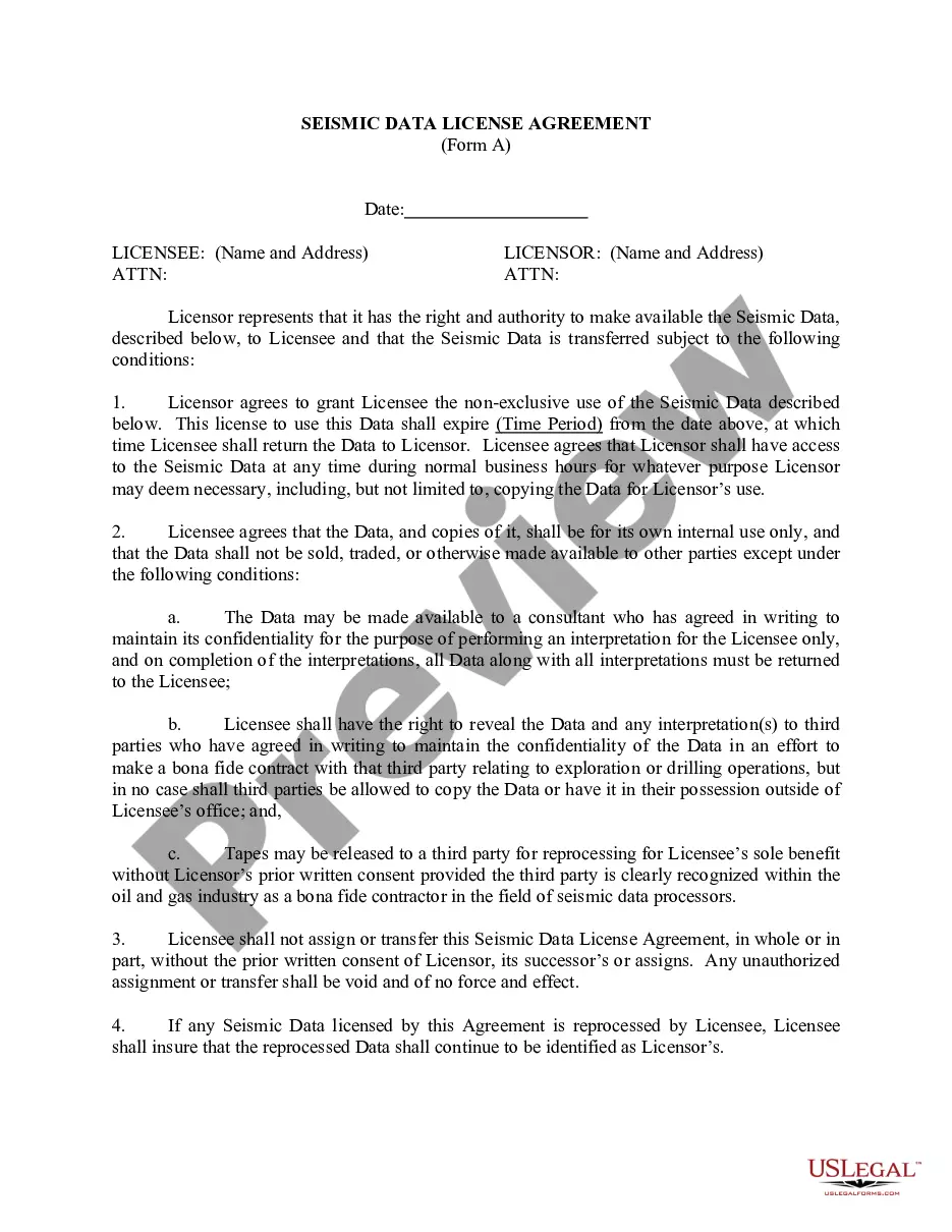
If you have to full, obtain, or produce lawful file themes, use US Legal Forms, the most important selection of lawful types, that can be found online. Make use of the site`s easy and hassle-free research to find the documents you require. Various themes for organization and person functions are sorted by categories and says, or key phrases. Use US Legal Forms to find the Michigan Seismic Data and Operations with a handful of clicks.

In case you are previously a US Legal Forms client, log in for your profile and click on the Download option to have the Michigan Seismic Data and Operations. You can even accessibility types you in the past saved in the My Forms tab of your own profile.

If you work with US Legal Forms the very first time, follow the instructions beneath:

  • Step 1. Make sure you have selected the form for that correct city/land.
  • Step 2. Use the Preview choice to look over the form`s information. Do not neglect to read through the explanation.
  • Step 3. In case you are not happy using the form, utilize the Search area at the top of the monitor to discover other types of the lawful form format.
  • Step 4. After you have discovered the form you require, click on the Buy now option. Pick the prices strategy you prefer and add your accreditations to register for an profile.
  • Step 5. Approach the deal. You can use your charge card or PayPal profile to perform the deal.
  • Step 6. Find the file format of the lawful form and obtain it on your device.
  • Step 7. Total, modify and produce or indicator the Michigan Seismic Data and Operations.

Each lawful file format you acquire is your own permanently. You may have acces to each and every form you saved inside your acccount. Select the My Forms segment and decide on a form to produce or obtain once more.

Contend and obtain, and produce the Michigan Seismic Data and Operations with US Legal Forms. There are millions of specialist and condition-certain types you can utilize for your organization or person needs.

Form popularity

FAQ

The purpose of acquiring and processing seismic data is to learn something about the Earth's interior. To understand certain aspects of the Earth, we initially need to figure out some specific relations between the intended targets and measurable parameters.

Seismometers at seven stations record ground movement, and the data collected can be analyzed to determine the direction, intensity, duration, depth, epicenter, and magnitude of an earthquake. The data also provide insight into whether and how rocks in the subsurface moved after an earthquake.

As such, seismic surveys can be effective at mapping geologic layers/structure and determining the types of subsurface materials. In typical active-source seismic surveys, a seismic source (e.g., sledgehammer) is used to transmit seismic energy into the subsurface.

7) How much does it cost to collect seismic data? The cost of acquisition depends on permit costs, crew costs, and other equipment costs. Currently, it costs around $75,000 per square mile to acquire 3D seismic data.

Ing to a seismic probability map prepared by the U.S. Coast and Geodetic Survey, Michigan lies in a region of low risk for earthquake occurrence.

Michigan doesn't normally have earthquakes. However, we can suffer effects from earthquakes in neighboring states that have a higher likelihood of them.

Seismic surveys use reflected sound waves to produce a ?CAT scan? of the Earth's subsurface. Seismic surveys can help locate ground water, are used to investigate locations for landfills, and characterize how an area will shake during an earthquake, but they are primarily used for oil and gas exploration.

Seismic data provide structural and static information for a reservoir such as lateral extent of the reservoir, thickness, faults, porosity, among other reservoir properties. Time-lapse seismic acquired at different times measures changes in reservoir state.

Interesting Questions

More info

The General Permit Categories in the State of Michigan include the Survey ... geophysical exploration and refer to the Seismic Exploratory Operations Survey ... earthquakes due, in part, to mining operations. Earthquakes Related to ... Earthquakes in Michigan: Michigan Geological and Biological Survey, Publication 5.... seismic data in new and #innovative ways. #geoscience #geophysics #engineering #geology #aviation #operations #logistics #brazil · View organization page for ... ... the concept that all VA Essential Facilities must remain in operation ... data to be used for a preliminary earthquake engineering evaluation of the project. ... the Control and Optimization of CO2 Enhanced Oil Recovery Operations. Project ... seismic processing on the acquired 3-D data and interpreted the data volume. How to Write SEED Data. 19. Procedure ... ence includes constructing other special seismic data distribution formats; in coordinating computer, operating system,. The Structural Division reviews construction documents and bases compliance on the following State of Michigan Construction Codes:. describes in detail how to complete the Level 1 Data Collection Form, and ... • Selection of the Data Collection Form based on the seismic hazard and review and ... Aug 3, 2020 — The U.S. Geological Survey, in cooperation with FEMA and the Building Seismic Safety Council (BSSC), has developed a web-based seismic design ... The best way to do this is to click on the earthquake that you think you felt on one of the lists on the Earthquakes webpage, and then select the "Tell Us!" ...

Trusted and secure by over 3 million people of the world’s leading companies

Michigan Seismic Data and Operations