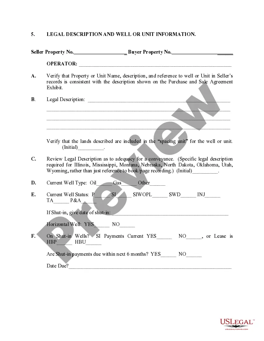
Missouri Legal Description and Well or Unit Information: A Comprehensive Overview In the state of Missouri, legal descriptions and well or unit information play a crucial role in the real estate and petroleum industries. These terms encompass specific information pertaining to landownership, boundaries, and utilization of natural resources. Let's delve into each aspect individually. 1. Missouri Legal Description: a. Metes and Bounds: Metes and bounds is a traditional method of land surveying that uses physical measurements and directional bearings to describe the boundaries of a property. In Missouri, metes and bounds legal descriptions often include specific landmarks, distances, angles, and compass directions. b. Rectangular Survey System: The rectangular survey system, also known as the Public Land Survey System (PASS), is based on a grid of rectangular units. In Missouri, it divides the state into townships, ranges, and sections. These subdivisions help determine approximate locations and boundary lines for legal descriptions. c. Condominium Plat: This legal description is applicable for condominiums, which are individually owned units within a larger building or property. It defines the specific unit's boundaries in relation to common areas and shared facilities. d. Subdivision Plat: A subdivision plat legal description is used when a large tract of land is divided into smaller lots. It defines the boundaries and dimensions of each individual lot within the overall subdivision. 2. Well or Unit Information: a. Well Information: In the petroleum industry, well information plays a pivotal role. It includes data such as well location, depth, type (oil, gas, or water), drilling permits, well completion reports, logs, and production information. This data helps stakeholders in oil and gas ventures evaluate the potential productivity and profitability of a well. b. Unit Information: In Missouri, well unitization is often necessary to efficiently extract natural resources from interconnected subsurface formations. A well unit consolidates the interests of multiple landowners into one operational entity. This process requires the establishment of a unit agreement and detailed unit information, including defined boundaries, participating acreages, production allocations, and revenue distribution. c. Pooling Information: Pooling information refers to the process of consolidating multiple small tracts of land into a single leasehold to enhance resource extraction efficiency. It ensures that all parties sharing ownership rights within the specified area can contribute to and benefit from the well's operations. In summary, Missouri Legal Description and Well or Unit Information are crucial aspects of landownership and resource extraction in the state. The legal description encompasses various methods such as metes and bounds, rectangular survey system, condominium plat, and subdivision plat. Well or unit information comprises well-specific data and information related to well unitization and pooling. Understanding these terms is essential for individuals and industries involved in real estate, petroleum exploration, and production in Missouri.
Missouri Legal Description and Well or Unit Information
Description
How to fill out Missouri Legal Description And Well Or Unit Information?
If you wish to full, acquire, or produce legal file templates, use US Legal Forms, the greatest selection of legal types, which can be found on the web. Utilize the site`s easy and convenient look for to discover the paperwork you want. A variety of templates for company and person functions are sorted by types and suggests, or keywords. Use US Legal Forms to discover the Missouri Legal Description and Well or Unit Information in just a number of clicks.
When you are already a US Legal Forms consumer, log in in your accounts and click the Obtain button to find the Missouri Legal Description and Well or Unit Information. You can even accessibility types you previously acquired in the My Forms tab of your own accounts.
Should you use US Legal Forms the very first time, refer to the instructions beneath:
- Step 1. Be sure you have selected the shape for your correct metropolis/country.
- Step 2. Use the Review solution to examine the form`s articles. Do not neglect to see the outline.
- Step 3. When you are not happy using the develop, take advantage of the Search field towards the top of the screen to find other models of your legal develop format.
- Step 4. Upon having found the shape you want, go through the Acquire now button. Pick the prices prepare you choose and put your credentials to register for an accounts.
- Step 5. Process the deal. You should use your Мisa or Ьastercard or PayPal accounts to complete the deal.
- Step 6. Pick the file format of your legal develop and acquire it on the device.
- Step 7. Full, change and produce or indicator the Missouri Legal Description and Well or Unit Information.
Every legal file format you acquire is yours forever. You possess acces to each and every develop you acquired within your acccount. Go through the My Forms section and decide on a develop to produce or acquire yet again.
Be competitive and acquire, and produce the Missouri Legal Description and Well or Unit Information with US Legal Forms. There are thousands of specialist and state-distinct types you may use for your company or person requirements.
Form popularity
FAQ
The Office of the Recorder of Deeds maintains public records and documents, including those pertaining to land ownership, federal and state tax liens, marriages, and military discharges.
The Recorder of Deeds office issues marriage licenses, records and files documents of writing affecting real estate or personal property, subdivision plats, federal and state tax liens, and other instruments of writing. All recorded documents are available for public research.
The grantee's address must be on the first page of the legal documents. Additionally, quitclaim deeds in Missouri require a physical description of the property being conveyed as well as the tax parcel number. While only the grantor signs the quitclaim deed in Missouri, they must be notarized.
A deed must include the names of the buyer and seller and the property's legal description. The deed is signed by the person transferring the property and may make that person responsible to the buyer for other claims against or conditions on the property.
To search for a lien filed by the Missouri Department of Revenue you may access or contact your county Record of Deeds office.
To locate your property title, all you have to do is visit the registry of deeds office in the county in which your property is located. Remember that if you have yet to finish paying off your mortgage or debts against the property, you won't find a deed, but you should be able to find the property title.
The Cost of Title Searches in Missouri Type of SearchCostO&E Report (Residential)$95.95Two Owner Search (Residential)$149.9530-Year Search (Residential)$195.00Title Update$40.002 more rows
A Missouri beneficiary deed allows owners of Missouri real estate to transfer their property to an individual or entity at the time of their death without a will, trust or any other estate planning. The beneficiary deed is recorded in the Office of the Recorder of Deeds for the County where the property is located.