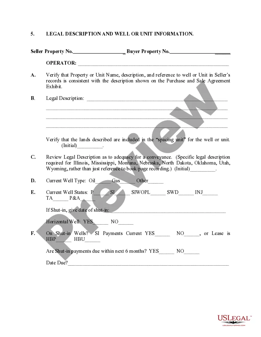
Montana Legal Description and Well or Unit Information play crucial roles in the oil and gas industry and real estate transactions. The precise and comprehensive details provided by these descriptions and information serve as important references for various purposes like property identification, land transfers, and resource extraction. In Montana, there are different types of legal descriptions and well or unit information used, each serving distinct purposes. Montana Legal Description: 1. Metes and Bounds: The Metes and Bounds legal description relies on a combination of directions, distances, and physical markers (such as monuments or natural features) to delineate the boundaries of a property. It describes an irregularly-shaped parcel of land by tracing its perimeter. 2. Lot and Block: The Lot and Block legal description is commonly used in platted subdivisions. It assigns specific lot numbers and block numbers to identify and define individual parcels within the subdivision. The accompanying plat map provides a visual representation of the subdivision layout. 3. Government Land Survey System: Montana, like many other western states, follows a grid-based system known as the Government Land Survey System (GLASS). This system divides land into townships, ranges, and sections, with each section covering one square mile. The GLASS legal description identifies land by specifying its township (T), range (R), and section (S) numbers. Well or Unit Information: 1. Well Location: Well information includes the precise location of an oil or gas well on a property. It typically includes latitude and longitude coordinates or specific references to section, township, and range. 2. Well Type: Different types of wells are used to extract various natural resources, such as oil, gas, or water. Well information specifies the specific type of well on a property. 3. Unit Designation: In the context of oil and gas operations, a unit is a specific area of land encompassing multiple oil or gas wells drilled to extract resources from a common reservoir. Unit information details the applicable unit designation and may include unit boundaries and details of participating wells. 4. Well Ownership: This information indicates who owns or operates the well, whether it is an individual, a company, or a cooperative. It can also provide additional details about any royalty or lease agreements. Accurate Montana Legal Descriptions and Well or Unit Information are essential for legal, operational, and regulatory purposes in the state's real estate and natural resources sectors.
Montana Legal Description and Well or Unit Information
Description
How to fill out Montana Legal Description And Well Or Unit Information?
Are you currently in a position in which you will need paperwork for either enterprise or individual reasons virtually every time? There are a variety of legal document themes accessible on the Internet, but finding ones you can trust is not effortless. US Legal Forms gives a huge number of develop themes, such as the Montana Legal Description and Well or Unit Information, that happen to be published to meet state and federal requirements.
In case you are currently acquainted with US Legal Forms website and also have a free account, just log in. Next, you are able to obtain the Montana Legal Description and Well or Unit Information design.
If you do not provide an profile and need to begin using US Legal Forms, follow these steps:
- Find the develop you want and ensure it is for that correct town/region.
- Make use of the Preview button to review the form.
- Look at the information to ensure that you have chosen the right develop.
- When the develop is not what you`re trying to find, take advantage of the Lookup field to get the develop that meets your needs and requirements.
- If you get the correct develop, click Get now.
- Choose the costs program you desire, fill out the desired info to create your account, and pay for the transaction with your PayPal or credit card.
- Decide on a practical document structure and obtain your backup.
Locate all of the document themes you may have bought in the My Forms menu. You can get a further backup of Montana Legal Description and Well or Unit Information at any time, if possible. Just click on the necessary develop to obtain or print the document design.
Use US Legal Forms, one of the most substantial variety of legal varieties, to save lots of time as well as prevent errors. The service gives professionally created legal document themes that can be used for a range of reasons. Create a free account on US Legal Forms and commence producing your lifestyle a little easier.
Form popularity
FAQ
Your geocode is available on Montana Cadastral. Cadastral is a database maintained by the Montana State Library. It allows the public to view information about public and private land ownership in Montana, including your geocode. Using Cadastral to find your Geocode for the Montana Property Tax Rebate mtrevenue.gov ? Geocode_Step-by-step_Final mtrevenue.gov ? Geocode_Step-by-step_Final
Cadastral data is the information about rights and interest in land. The data may also be known as real estate data, parcel information, land ownership, or tax parcel information. The Montana Cadastral Framework data consists of tax parcels defined by the Montana Department of Revenue and City/County GIS Departments. MSDI Cadastral - Montana State Library mt.gov ? geoinfo ? msdi ? cadastral mt.gov ? geoinfo ? msdi ? cadastral
A land description is used to describe a specific plot of land or property. They can be used to locate any parcel throughout the state of Montana through the written description. These written descriptions are also called legal descriptions and are unique to each property.
There are three common methods used to describe real estate: metes and bounds, government survey, and lot and block. Here's a closer look at how they work. Metes and bounds is a term used in describing the boundary lines of land, setting forth all the boundary lines together with their terminal points and angles.
The three types of legal descriptions you're likely to encounter include: Metes and bounds. Rectangular Survey System (also known as Public Land Survey System or government survey method) Plat method or lot and block method.
A legal description is the exact location and measure of the real estate. Although an address is often used to locate a property, legal descriptions are used when transferring titles because they are more accurate. What Does It Mean by Legal Description | Northern California ... nceca.org ? what-does-it-mean-by-legal-description nceca.org ? what-does-it-mean-by-legal-description
Defining Land Description A land description is used to describe a specific plot of land or property. They can be used to locate any parcel throughout the state of Montana through the written description. These written descriptions are also called legal descriptions and are unique to each property. Legal Land Descriptions in Montana: Definition & Functions | Study.com study.com ? academy ? lesson ? legal-land-descri... study.com ? academy ? lesson ? legal-land-descri...
The legal description of land follows a set sequence of quarter section, township, range, and meridian: the designation NW 27-9-25 W2, for instance, means the Northwest Quarter of Section 27 in Township 9 Range 25 West of the Second Meridian.