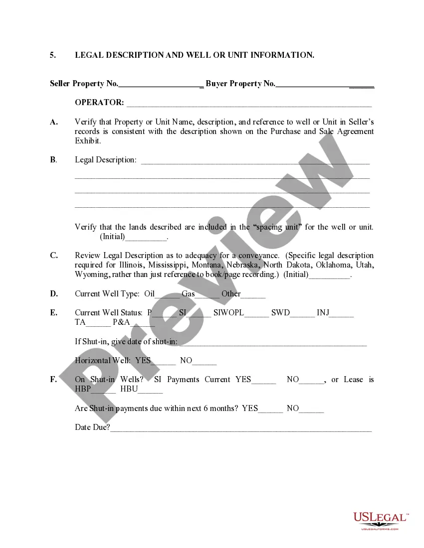
North Dakota Legal Description and Well or Unit Information play a crucial role in the management and exploration of oil and gas resources within the state. These descriptions provide a detailed account of the location, boundaries, and ownership rights of particular wells or units in North Dakota. Several types of legal descriptions and well or unit information are used, including: 1. North Dakota Legal Description: The North Dakota Legal Description is a precise and standardized method used to identify and define the boundaries of a specific piece of land within the state. It typically includes: — Township, Range, and Section: North Dakota is divided into a grid system referred to as the Public Land Survey System (PASS). Each township is six miles square and contains 36 sections, each consisting of one square mile. The township, range, and section help pinpoint the exact location of a property. — Meridian and Baseline: North Dakota uses the Fifth Principal Meridian and the Baseline. The Meridian is an imaginary line north-south, while the Baseline is an imaginary line east-west, intersecting to form the starting point of the PASS grid. 2. Well or Unit Information: Well or Unit Information provides data related to particular oil or gas wells located in North Dakota. It includes: — API Number: The American Petroleum Institute (API) number uniquely identifies each well in North Dakota. It helps in tracking the production, drilling, and completion records of the well. — Well Name and Number: A well is usually assigned a specific name and number based on various factors, including its location, operator, or lease. This identification facilitates communication and data management. Well borere Orientation: Wellbore orientation describes the vertical and horizontal measurements of the well. It includes the depth, inclination, and azimuth, which determine the trajectory of the well and its direction. — Spacing Unit: The spacing unit defines the designated area where the well can extract oil or gas resources. It sets the allowable distances between wells to efficiently drain the hydrocarbon reservoir while minimizing interference between adjacent wells. — Ownership: The ownership section of well or unit information specifies the entities or individuals who have the rights to the minerals extracted from the well. It may include the leaseholder, operator, working interest owners, and royalty owners. By combining the North Dakota Legal Description with Well or Unit Information, operators, regulators, and interested parties can accurately communicate and manage the exploration, production, and ownership details of oil and gas activities in North Dakota.
North Dakota Legal Description and Well or Unit Information
Description
How to fill out North Dakota Legal Description And Well Or Unit Information?
If you wish to total, acquire, or print legitimate file web templates, use US Legal Forms, the most important selection of legitimate types, which can be found on the Internet. Take advantage of the site`s easy and practical lookup to get the paperwork you will need. Different web templates for organization and personal uses are categorized by types and suggests, or keywords. Use US Legal Forms to get the North Dakota Legal Description and Well or Unit Information in just a couple of click throughs.
Should you be already a US Legal Forms buyer, log in to your profile and then click the Acquire switch to obtain the North Dakota Legal Description and Well or Unit Information. You may also gain access to types you earlier downloaded from the My Forms tab of the profile.
If you use US Legal Forms the first time, follow the instructions below:
- Step 1. Be sure you have selected the shape for that appropriate area/country.
- Step 2. Make use of the Review option to look over the form`s information. Do not neglect to learn the outline.
- Step 3. Should you be not happy with the kind, make use of the Look for discipline at the top of the monitor to locate other models of the legitimate kind template.
- Step 4. When you have located the shape you will need, select the Purchase now switch. Select the prices strategy you choose and include your accreditations to sign up for the profile.
- Step 5. Process the deal. You can use your credit card or PayPal profile to complete the deal.
- Step 6. Find the file format of the legitimate kind and acquire it in your system.
- Step 7. Complete, revise and print or sign the North Dakota Legal Description and Well or Unit Information.
Each legitimate file template you purchase is your own property for a long time. You possess acces to each and every kind you downloaded within your acccount. Click the My Forms area and pick a kind to print or acquire once again.
Contend and acquire, and print the North Dakota Legal Description and Well or Unit Information with US Legal Forms. There are millions of expert and status-certain types you may use to your organization or personal requires.