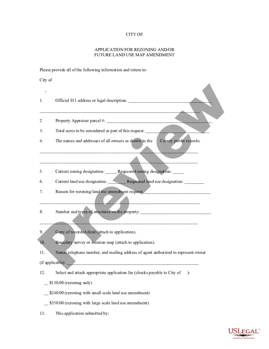
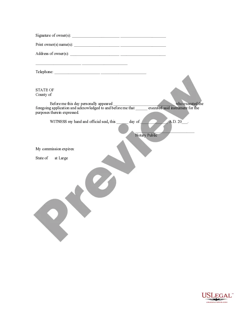
Title: Understanding the New Hampshire Application for Rezoning and Future Land Use Map Amendment Introduction: The New Hampshire Application for Rezoning and Future Land Use Map Amendment entails a detailed and structured process designed to manage changes in land use across the state. This article will explore the purpose of these applications, their significance, and any different types that may exist. Keywords: New Hampshire, Application for Rezoning, Future Land Use Map Amendment 1. Purpose of the New Hampshire Application for Rezoning: The New Hampshire Application for Rezoning is a formal request made by individuals, organizations, or local authorities to change the designated land use of a specific property. The purpose of this application is to evaluate the potential benefit, impact, and compatibility of proposed changes within the existing zoning regulations. 2. Importance of Future Land Use Map Amendment: The Future Land Use Map Amendment serves as a component within the broader framework of local and regional comprehensive planning processes. Its primary purpose is to facilitate the strategic adjustment of land use designations based on evolving community needs, market trends, or development priorities. 3. Different Types of New Hampshire Application for Rezoning and Future Land Use Map Amendment: While the terminology for these applications may vary depending on the locality, the core objective remains the same. Here are a few distinct types that may be encountered in New Hampshire: a. Residential Rezoning: Residential rezoning refers to a specific instance where an applicant seeks to convert land initially designated for commercial, agricultural, or other purposes into residential use. This type of rezoning can accommodate new housing developments, multi-family dwellings, or assisted living facilities. b. Commercial/Industrial Rezoning: Commercial/industrial rezoning involves changing the land use classification from residential or agricultural to commercial or industrial purposes. This may allow for the construction of shopping centers, office buildings, manufacturing facilities, or warehouses. c. Mixed-Use Rezoning: Mixed-use rezoning pertains to converting an area that previously had a single primary land use designation into a blend of residential, commercial, and/or industrial activities. This type of rezoning can foster vibrant communities that offer a mix of housing, amenities, entertainment, and employment opportunities. d. Conservation or Recreational Rezoning: Conservation or recreational rezoning focuses on designating specific areas as protected lands, parks, or open spaces. This type of rezoning prioritizes the preservation of natural resources, wildlife habitats, and public access to outdoor recreational activities. 4. Process and Requirements: The application process for rezoning and future land use map amendment typically involves submitting a formal request to the respective local planning board, along with relevant documentation such as surveys, development plans, and environmental impact assessments. The applicant may need to participate in public hearings and engage in consultation with stakeholders and neighboring property owners before obtaining approval. Conclusion: The New Hampshire Application for Rezoning and Future Land Use Map Amendment is a vital tool in managing land use changes within the state. By understanding these applications and the different types that exist, individuals and entities can navigate the process more effectively to accommodate growth, development, and sustainable land use practices.
Title: Understanding the New Hampshire Application for Rezoning and Future Land Use Map Amendment Introduction: The New Hampshire Application for Rezoning and Future Land Use Map Amendment entails a detailed and structured process designed to manage changes in land use across the state. This article will explore the purpose of these applications, their significance, and any different types that may exist. Keywords: New Hampshire, Application for Rezoning, Future Land Use Map Amendment 1. Purpose of the New Hampshire Application for Rezoning: The New Hampshire Application for Rezoning is a formal request made by individuals, organizations, or local authorities to change the designated land use of a specific property. The purpose of this application is to evaluate the potential benefit, impact, and compatibility of proposed changes within the existing zoning regulations. 2. Importance of Future Land Use Map Amendment: The Future Land Use Map Amendment serves as a component within the broader framework of local and regional comprehensive planning processes. Its primary purpose is to facilitate the strategic adjustment of land use designations based on evolving community needs, market trends, or development priorities. 3. Different Types of New Hampshire Application for Rezoning and Future Land Use Map Amendment: While the terminology for these applications may vary depending on the locality, the core objective remains the same. Here are a few distinct types that may be encountered in New Hampshire: a. Residential Rezoning: Residential rezoning refers to a specific instance where an applicant seeks to convert land initially designated for commercial, agricultural, or other purposes into residential use. This type of rezoning can accommodate new housing developments, multi-family dwellings, or assisted living facilities. b. Commercial/Industrial Rezoning: Commercial/industrial rezoning involves changing the land use classification from residential or agricultural to commercial or industrial purposes. This may allow for the construction of shopping centers, office buildings, manufacturing facilities, or warehouses. c. Mixed-Use Rezoning: Mixed-use rezoning pertains to converting an area that previously had a single primary land use designation into a blend of residential, commercial, and/or industrial activities. This type of rezoning can foster vibrant communities that offer a mix of housing, amenities, entertainment, and employment opportunities. d. Conservation or Recreational Rezoning: Conservation or recreational rezoning focuses on designating specific areas as protected lands, parks, or open spaces. This type of rezoning prioritizes the preservation of natural resources, wildlife habitats, and public access to outdoor recreational activities. 4. Process and Requirements: The application process for rezoning and future land use map amendment typically involves submitting a formal request to the respective local planning board, along with relevant documentation such as surveys, development plans, and environmental impact assessments. The applicant may need to participate in public hearings and engage in consultation with stakeholders and neighboring property owners before obtaining approval. Conclusion: The New Hampshire Application for Rezoning and Future Land Use Map Amendment is a vital tool in managing land use changes within the state. By understanding these applications and the different types that exist, individuals and entities can navigate the process more effectively to accommodate growth, development, and sustainable land use practices.