• US Legal Forms

New Mexico Application for Rezoning and / or Future Land Use Map Amendment

State:
Multi-State
Control #:
US-M-9693
Format:
Word; 
Rich Text
Instant download

Description

This is a sample of Municipal Codes when dealing with an ordinance concerning the application for rezoning and/or future land use map amendments. This may be used across the United States.
In New Mexico, the Application for Rezoning and/or Future Land Use Map Amendment is a crucial document utilized by individuals, businesses, and organizations seeking to make changes to the zoning designation or future land use designation of a particular property or area. This application acts as a formal request to local government authorities, such as city or county planning departments, to modify existing zoning regulations or future land use plans to accommodate specific development intentions or projects. The process of rezoning and/or amending the future land use map is undertaken to ensure the proper allocation of land use and development in accordance with changing community needs, economic growth, or other factors. The approval of these applications is typically contingent upon a thorough review process, including public hearings, community input, and compliance with applicable laws, regulations, and comprehensive plans. The New Mexico Application for Rezoning and/or Future Land Use Map Amendment involves a detailed submission, outlining the proposed changes and its alignment with the long-term goals and objectives of the local jurisdiction. The application may vary slightly depending on the specific requirements and procedures of each municipality or county; however, the core elements generally include: 1. Applicant Information: This section requires the name, address, contact details, and signature of the party or organization initiating the rezoning or future land use map amendment process. The applicant might be the property owner, developer, or their authorized representative. 2. Property Details: Here, precise information about the property subject to the application is provided, such as the legal description, address, size, and any existing zoning and land use designations. 3. Proposed Changes: This section delineates the desired modifications to the existing zoning or future land use map. It specifies if it is a rezoning application, a future land use map amendment request, or both, along with the proposed new zoning category or revised land use designation. 4. Justification: Applicants must provide a comprehensive justification for the proposed changes, presenting arguments and evidence to support their request. This may include demonstrating the compatibility with surrounding land uses, economic benefits, environmental considerations, or the fulfillment of strategic community objectives. 5. Site Plan and Impact Assessment: Depending on the nature and scale of the proposed changes, applicants may need to submit a site plan illustrating the intended development, expanded use, or revised land use. Additionally, an impact assessment might be required, analyzing potential effects on traffic, infrastructure, utilities, public services, and the environment. 6. Applicable Fees and Documentation: The application typically necessitates payment of applicable fees and the submission of additional documents, such as surveys, legal descriptions, ownership proofs, environmental reports, or supporting studies. Different types of New Mexico Application for Rezoning and/or Future Land Use Map Amendment can arise due to varied development goals and land use complexities. Some potential categorizations include residential rezoning, commercial rezoning, industrial rezoning, agricultural rezoning, or mixed-use rezoning. Each specific type entails distinct criteria and considerations tailored to the desired land use change within the specific zone or region. Overall, the New Mexico Application for Rezoning and/or Future Land Use Map Amendment is a pivotal tool for those seeking to shape the land use and development framework within the state. Properly completing and submitting this application ensures that local authorities can make informed decisions regarding zoning changes that align with long-term community planning and development objectives.

In New Mexico, the Application for Rezoning and/or Future Land Use Map Amendment is a crucial document utilized by individuals, businesses, and organizations seeking to make changes to the zoning designation or future land use designation of a particular property or area. This application acts as a formal request to local government authorities, such as city or county planning departments, to modify existing zoning regulations or future land use plans to accommodate specific development intentions or projects. The process of rezoning and/or amending the future land use map is undertaken to ensure the proper allocation of land use and development in accordance with changing community needs, economic growth, or other factors. The approval of these applications is typically contingent upon a thorough review process, including public hearings, community input, and compliance with applicable laws, regulations, and comprehensive plans. The New Mexico Application for Rezoning and/or Future Land Use Map Amendment involves a detailed submission, outlining the proposed changes and its alignment with the long-term goals and objectives of the local jurisdiction. The application may vary slightly depending on the specific requirements and procedures of each municipality or county; however, the core elements generally include: 1. Applicant Information: This section requires the name, address, contact details, and signature of the party or organization initiating the rezoning or future land use map amendment process. The applicant might be the property owner, developer, or their authorized representative. 2. Property Details: Here, precise information about the property subject to the application is provided, such as the legal description, address, size, and any existing zoning and land use designations. 3. Proposed Changes: This section delineates the desired modifications to the existing zoning or future land use map. It specifies if it is a rezoning application, a future land use map amendment request, or both, along with the proposed new zoning category or revised land use designation. 4. Justification: Applicants must provide a comprehensive justification for the proposed changes, presenting arguments and evidence to support their request. This may include demonstrating the compatibility with surrounding land uses, economic benefits, environmental considerations, or the fulfillment of strategic community objectives. 5. Site Plan and Impact Assessment: Depending on the nature and scale of the proposed changes, applicants may need to submit a site plan illustrating the intended development, expanded use, or revised land use. Additionally, an impact assessment might be required, analyzing potential effects on traffic, infrastructure, utilities, public services, and the environment. 6. Applicable Fees and Documentation: The application typically necessitates payment of applicable fees and the submission of additional documents, such as surveys, legal descriptions, ownership proofs, environmental reports, or supporting studies. Different types of New Mexico Application for Rezoning and/or Future Land Use Map Amendment can arise due to varied development goals and land use complexities. Some potential categorizations include residential rezoning, commercial rezoning, industrial rezoning, agricultural rezoning, or mixed-use rezoning. Each specific type entails distinct criteria and considerations tailored to the desired land use change within the specific zone or region. Overall, the New Mexico Application for Rezoning and/or Future Land Use Map Amendment is a pivotal tool for those seeking to shape the land use and development framework within the state. Properly completing and submitting this application ensures that local authorities can make informed decisions regarding zoning changes that align with long-term community planning and development objectives.

Free preview
  • Form preview
  • Form preview

How to fill out New Mexico Application For Rezoning And / Or Future Land Use Map Amendment?

US Legal Forms - one of the largest libraries of authorized kinds in the States - provides a wide array of authorized document web templates it is possible to down load or print. Utilizing the website, you can get thousands of kinds for company and individual uses, sorted by classes, states, or key phrases.You can find the latest variations of kinds much like the New Mexico Application for Rezoning and / or Future Land Use Map Amendment within minutes.

If you have a registration, log in and down load New Mexico Application for Rezoning and / or Future Land Use Map Amendment from your US Legal Forms library. The Download button can look on every single type you perspective. You get access to all formerly delivered electronically kinds inside the My Forms tab of your own accounts.

In order to use US Legal Forms the very first time, allow me to share easy recommendations to help you get began:

  • Ensure you have selected the proper type for your personal area/region. Click on the Review button to examine the form`s information. See the type information to actually have selected the appropriate type.
  • When the type does not fit your needs, use the Research industry at the top of the display screen to get the the one that does.
  • If you are satisfied with the form, validate your selection by visiting the Buy now button. Then, select the prices strategy you like and give your references to register to have an accounts.
  • Approach the financial transaction. Make use of Visa or Mastercard or PayPal accounts to complete the financial transaction.
  • Select the structure and down load the form on the system.
  • Make changes. Load, change and print and indication the delivered electronically New Mexico Application for Rezoning and / or Future Land Use Map Amendment.

Every template you put into your account does not have an expiration particular date and is yours forever. So, if you would like down load or print an additional backup, just visit the My Forms segment and click in the type you will need.

Gain access to the New Mexico Application for Rezoning and / or Future Land Use Map Amendment with US Legal Forms, the most considerable library of authorized document web templates. Use thousands of professional and express-distinct web templates that satisfy your small business or individual requires and needs.

Form popularity

FAQ

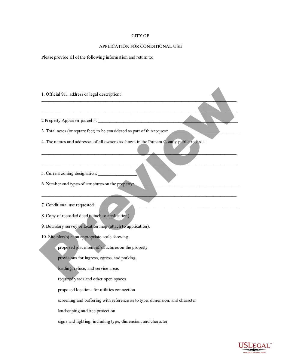
A conditional use permit is issued to the property owner for a specific use within the zoning district as allowed in the Land Use Chart (Exhibit A) of the Zoning Ordinance. When someone wishes to obtain a conditional use permit, an application for the permit is obtained from the Planning and Zoning Department.

Conditional use permits are based upon requests for specific activities in certain locations. These activities are specifically listed in the corresponding zone, and often include conditions and standards of approval.

Special Use Permits are a privilege granted by the County. It falls to the applicant to demonstrate the appropriateness of establishing the special use on the specific property. The Special Use Permit process usually takes about 90 days but can take longer if the issues are especially complex.

WHAT IS A CONDITIONAL USE PERMIT? ACONDITIONAL USE PERMIT (CUP) allows a city or county to consider special uses which may be essential or. desirable to a particular community, but which are not allowed as a matter of right within a zoning district, through a public hearing process.

The City of Albuquerque Uniform Administrative Code states that a building permit will not be required for one-story detached accessory buildings used as tool storage sheds, playhouses and similar uses, provided the building does not exceed 120 square feet.

Interesting Questions

More info

Jun 6, 2020 — Re: Request for a Master Plan and Zone Map Amendment. Dear Chairman, Heil: Consensus Planning is pleased to present this amendment to the ... Stability of land use and zoning is desirable; therefore, the applicant must ... List of any original or related file numbers on the cover application. Fee.Nov 7, 2022 — ... map amendments to the Official Zoning Map and Future Land Use. Map ... the City Code, Chapter 16, Land Development Regulations creating a new ... May 27, 2021 — ... map amendment on behalf of the land owner as a ... The applicant has the authority to make an application to request a zone map amendment. Nov 12, 2020 — SUBJECT: O39, Ordinance of the City of Rio Rancho, New Mexico Amending the Zoning Classification and. Official Zoning Map for Property ... Following receipt of a complete zoning map amendment application or initiation of zoning map amendment by the planning and zoning commission or the city ... ISSUE. Request for approval ofa General Plan Future Land Use Map amendment to change the ... The proposed rezoning will result in office type use which is ... The plot plan review application is consistent with the comprehensive plan, zoning ordinance, and all other applicable plans and regulations. ii. The proposed ... The Planning & Zoning Commission and City Council shall act upon the Concept Plan application in accordance with A. Zoning Map Amendments. The applicant or ... AMENDMENT TO ZONING CODE OR SUBDIVISION REGULATORY TEXT (EPC07). Amendment referenced to the sections of the Zone Code/Subdivision Regulations being amended.

Trusted and secure by over 3 million people of the world’s leading companies

New Mexico Application for Rezoning and / or Future Land Use Map Amendment