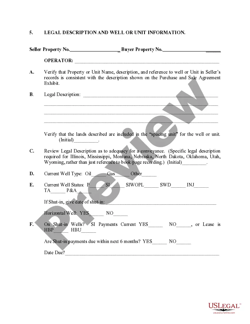
New Mexico Legal Description and Well or Unit Information play a vital role in the state's oil and gas industry. These terms are paramount for accurately identifying and locating oil and gas wells and units within the state. In New Mexico, there are various types of legal descriptions and well or unit information, each serving a specific purpose. Here, we will delve into the different types and explain their significance. 1. New Mexico Legal Description: — Metes and Bounds: This type of legal description utilizes precise measurements, angles, and distances to outline the boundaries of a particular area of land. By using natural and man-made landmarks as reference points, the metes and bounds legal description provides a detailed account of the property's shape and size. — Government Rectangular Survey System: Also known as the Public Land Survey System (PASS), this type of legal description divides land into townships, ranges, and sections based on meridians and baselines. Each township comprises 36 sections, which are then further divided to identify specific tracts of land. 2. Well Information: — API Number: The American Petroleum Institute (API) assigns unique identification numbers to each oil or gas well in the United States. API numbers are crucial for tracking and referencing well data and facilitate regulatory compliance and reporting. — Well Name: Each well is assigned a distinct name, typically attributed based on the leaseholder or a specific geographical feature near the well's location. Well names contribute to an organized system for identification and differentiation. — Geographic Coordinates: Latitude and longitude coordinates precisely pinpoint the geographical location of a well. These coordinates are essential for mapping, navigation, and facilitating accurate well placement. 3. Unit Information: — Unit Name: A unit name is a designated title given to a specific drilling or production area comprising multiple wells. Units are created to collectively operate and manage multiple wells that share common geological formations or are part of the same leasehold, optimizing production efficiency. — Unit Agreement: A legal document outlining the establishment, regulations, and rights associated with a unit. The unit agreement defines the responsibilities of unit operators and the participating working interest owners, ensuring a smooth functioning and distribution of revenue among stakeholders. The accurate recording and documentation of New Mexico Legal Description and Well or Unit Information are critical for landowners, industry operators, and regulatory bodies. These details enable efficient land management, lease negotiations, royalty calculations, and adherence to state and federal regulations. Furthermore, this information fosters transparency and communication between stakeholders while promoting the sustainable development of New Mexico's oil and gas reserves.
New Mexico Legal Description and Well or Unit Information
Description
How to fill out New Mexico Legal Description And Well Or Unit Information?
It is possible to commit time on the Internet attempting to find the authorized file design which fits the federal and state demands you need. US Legal Forms offers thousands of authorized types which are reviewed by pros. It is possible to download or print the New Mexico Legal Description and Well or Unit Information from the service.
If you already have a US Legal Forms accounts, you may log in and click on the Acquire option. Afterward, you may total, edit, print, or signal the New Mexico Legal Description and Well or Unit Information. Each and every authorized file design you acquire is your own property forever. To acquire yet another copy of the bought form, go to the My Forms tab and click on the corresponding option.
If you are using the US Legal Forms site initially, keep to the simple directions under:
- Initially, ensure that you have selected the right file design to the county/metropolis that you pick. See the form explanation to make sure you have chosen the proper form. If offered, take advantage of the Preview option to look with the file design too.
- In order to locate yet another version from the form, take advantage of the Lookup industry to discover the design that meets your requirements and demands.
- Upon having located the design you want, click on Buy now to carry on.
- Pick the rates prepare you want, enter your credentials, and register for your account on US Legal Forms.
- Full the transaction. You can utilize your charge card or PayPal accounts to pay for the authorized form.
- Pick the structure from the file and download it in your product.
- Make adjustments in your file if possible. It is possible to total, edit and signal and print New Mexico Legal Description and Well or Unit Information.
Acquire and print thousands of file layouts utilizing the US Legal Forms site, that provides the greatest collection of authorized types. Use professional and state-particular layouts to take on your business or person needs.