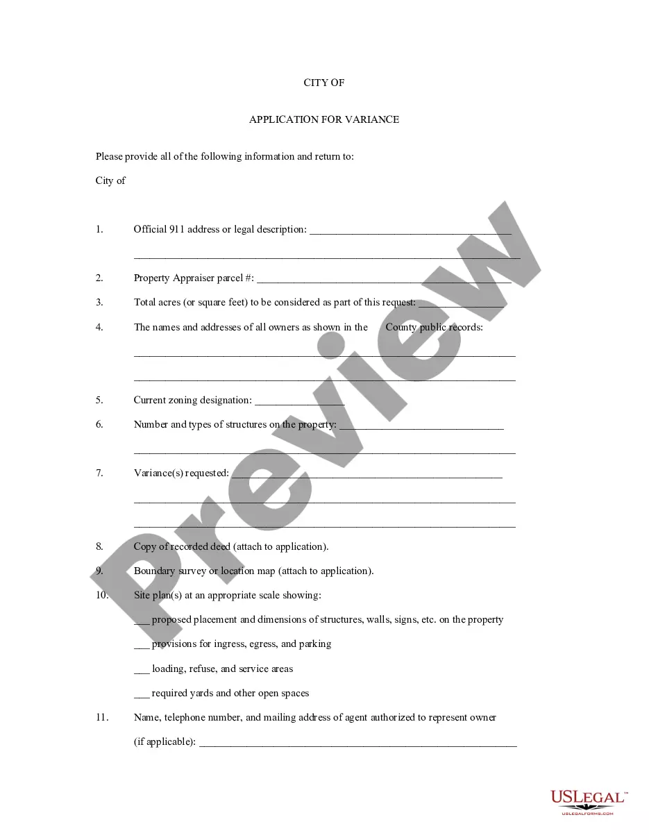
New York Application for Rezoning and / or Future Land Use Map Amendment
Description


Get your form ready online
Our built-in tools help you complete, sign, share, and store your documents in one place.
Make edits, fill in missing information, and update formatting in US Legal Forms—just like you would in MS Word.
Download a copy, print it, send it by email, or mail it via USPS—whatever works best for your next step.
Sign and collect signatures with our SignNow integration. Send to multiple recipients, set reminders, and more. Go Premium to unlock E-Sign.
If this form requires notarization, complete it online through a secure video call—no need to meet a notary in person or wait for an appointment.
We protect your documents and personal data by following strict security and privacy standards.

Make edits, fill in missing information, and update formatting in US Legal Forms—just like you would in MS Word.

Download a copy, print it, send it by email, or mail it via USPS—whatever works best for your next step.

Sign and collect signatures with our SignNow integration. Send to multiple recipients, set reminders, and more. Go Premium to unlock E-Sign.

If this form requires notarization, complete it online through a secure video call—no need to meet a notary in person or wait for an appointment.

We protect your documents and personal data by following strict security and privacy standards.
Looking for another form?
How to fill out Application For Rezoning And / Or Future Land Use Map Amendment?
Choosing the best authorized papers template might be a battle. Of course, there are plenty of layouts available on the Internet, but how can you get the authorized kind you require? Make use of the US Legal Forms internet site. The assistance offers thousands of layouts, for example the New York Application for Rezoning and / or Future Land Use Map Amendment, that can be used for business and personal needs. Each of the varieties are inspected by experts and fulfill state and federal specifications.
When you are already listed, log in for your bank account and click the Download switch to have the New York Application for Rezoning and / or Future Land Use Map Amendment. Make use of bank account to search through the authorized varieties you possess bought earlier. Visit the My Forms tab of your own bank account and have an additional duplicate from the papers you require.
When you are a whole new end user of US Legal Forms, listed here are basic guidelines that you should follow:
- Initially, make certain you have chosen the right kind for your town/state. You are able to examine the form utilizing the Review switch and look at the form description to guarantee this is the right one for you.
- In case the kind fails to fulfill your needs, use the Seach industry to obtain the right kind.
- When you are certain the form would work, click on the Buy now switch to have the kind.
- Opt for the rates prepare you would like and enter in the needed information and facts. Design your bank account and buy the transaction with your PayPal bank account or charge card.
- Opt for the document formatting and download the authorized papers template for your gadget.
- Full, revise and produce and indication the attained New York Application for Rezoning and / or Future Land Use Map Amendment.
US Legal Forms may be the biggest local library of authorized varieties where you will find a variety of papers layouts. Make use of the service to download expertly-made documents that follow status specifications.
Form popularity
FAQ
The NYC Department of Buildings (DOB) holds primary responsibility for interpreting and enforcing the City's Zoning Resolution to ensure the safe and lawful use of over one million buildings and construction sites across the five boroughs.
A (esidentialAgricultural) Zoning District. The A zoning district is intended to provide for areas appropriate for detached singlefamily residential dwelling units and light farming uses, each located on a single legal lot; B. 1 (SingleUnit esidential) Zoning District.
It establishes an orderly pattern of development across neighborhoods and the city by identifying what may be built on a piece of property. The Zoning Resolution contains the zoning regulations of New York City.
How can someone change the zoning on a property? Uniform Land Use Review Process (ULURP). This process includes review by and recommendations from the affected community board(s) and the Borough President. The City Planning Commission and ultimately the City Council decide whether to approve the zoning change.
However, on average a rezone can require at least 12-18 months to process. As with all discretionary actions, approval is not guaranteed. To determine the feasibility for processing a rezone, a Multi-Discipline Preliminary Review may be requested prior to applying for a rezone.
These new provisions stipulated that any change in zoning would require public hearings and several levels of nonbinding review. This procedure is called the uniform land use review process, or Ulurp (pronounced ?YOU-lurp?). A typical Ulurp review takes six to eight months.
The City is divided into three basic zoning districts: Residential (R), Commercial (C), and Manufacturing (M), which are then further divided into low, medium, and high density districts. There may be different zoning districts within the same neighborhood or city block.
How can someone change the zoning on a property? Uniform Land Use Review Process (ULURP). This process includes review by and recommendations from the affected community board(s) and the Borough President. The City Planning Commission and ultimately the City Council decide whether to approve the zoning change.