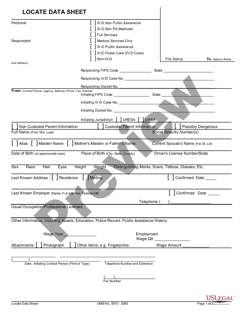
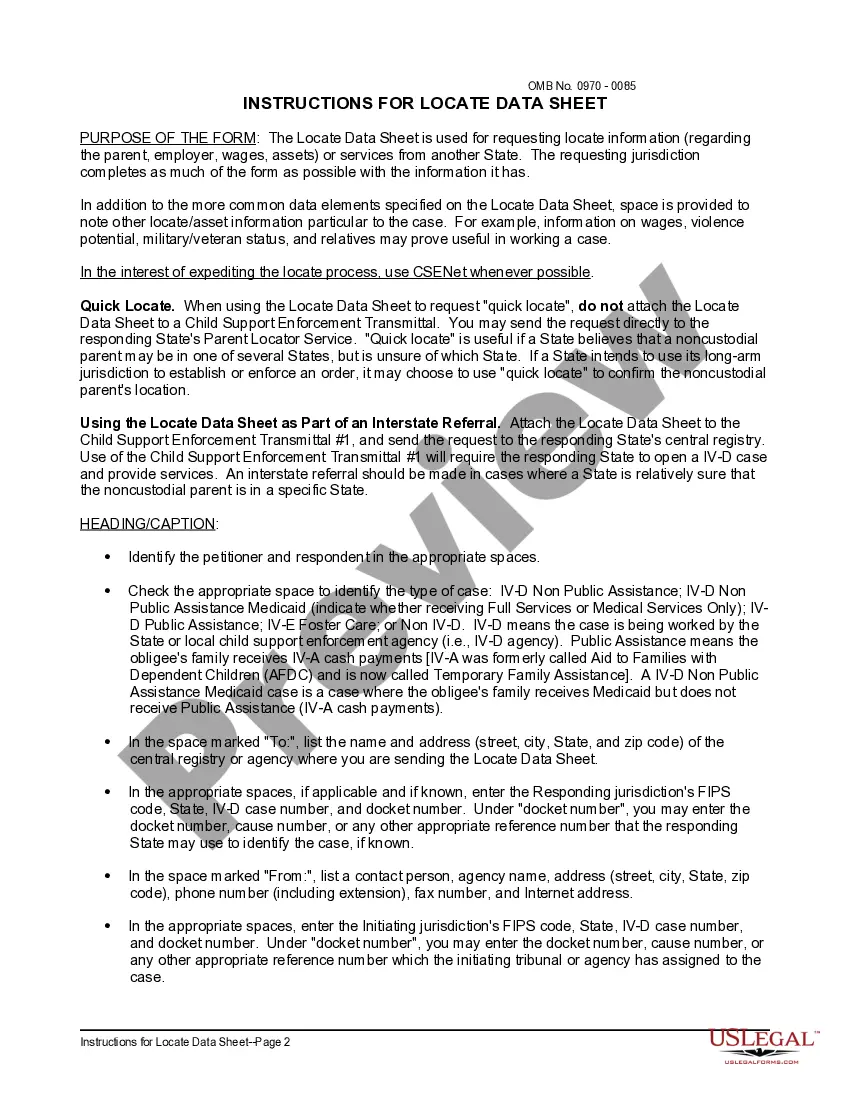
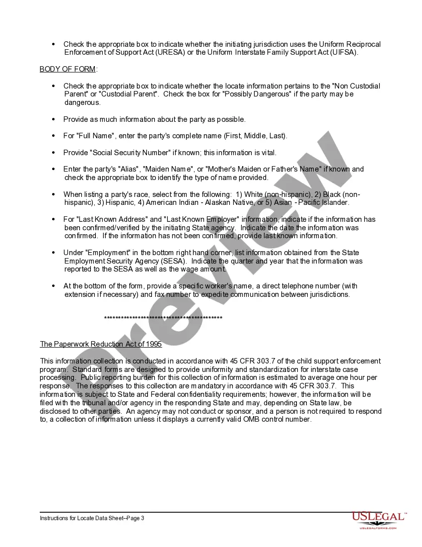
Ohio Locate Data Sheet and Instructions are essential documents that provide vital information and guidelines for accurately locating and identifying specific areas or properties in the state of Ohio, United States. These documents serve various purposes, including real estate transactions, construction projects, and infrastructure development. The Ohio Locate Data Sheet presents a comprehensive overview of the geographical details needed for precise identification and mapping. It includes relevant keywords such as longitude, latitude, parcel boundaries, elevation, topographic features, and spatial reference systems. The data sheet offers a detailed description of the specific location, enabling users to determine the precise position on a map. This information is crucial for conducting property surveys, developing accurate infrastructure plans, and facilitating efficient land management. Instructions accompanying the Ohio Locate Data Sheet outline the procedures and guidelines for utilizing the data effectively. These instructions include step-by-step guidance on how to interpret the data sheet, access digital maps, and use geospatial software for precise mapping and analysis. Additionally, the instructions provide information on how to collect the required field data, understand coordinate systems, and ensure data accuracy. In Ohio, there are several types of Locate Data Sheets and Instructions that cater to different needs and purposes. Some examples include: 1. Ohio Real Estate Locate Data Sheet and Instructions: Designed for real estate agents, property developers, and prospective buyers, these documents provide detailed information on specific properties, their boundaries, neighboring parcels, and any potential restrictions or encroachments. This type of data sheet is commonly used during property transactions, boundary disputes, or site selection for construction projects. 2. Ohio Infrastructure Development Locate Data Sheet and Instructions: Geared towards engineers, architects, and public works departments, these documents offer comprehensive information on existing infrastructures, such as roads, utilities, pipelines, and other amenities. The data sheets assist in planning new infrastructure projects, identifying potential conflicts or overlaps, and ensuring efficient design and implementation. 3. Ohio Environmental Locate Data Sheet and Instructions: These specialized documents are aimed at environmental consultants, researchers, and regulatory agencies. They provide detailed information on environmental features, such as wetlands, protected areas, streams, and soil types. The data sheets facilitate environmental assessments, impact analyses, and compliance with environmental regulations during project planning and development. In conclusion, Ohio Locate Data Sheet and Instructions play a vital role in accurately identifying and mapping locations within the state. With their detailed information and relevant keywords, they ensure precise mapping, improve decision-making, and promote efficient land management across various industries and sectors.
Ohio Locate Data Sheet and Instructions
Description
How to fill out Ohio Locate Data Sheet And Instructions?
US Legal Forms - among the biggest libraries of authorized kinds in the States - delivers an array of authorized papers templates you can download or print. While using internet site, you can get thousands of kinds for company and specific reasons, sorted by groups, says, or key phrases.You will find the newest types of kinds like the Ohio Locate Data Sheet and Instructions in seconds.
If you already possess a subscription, log in and download Ohio Locate Data Sheet and Instructions in the US Legal Forms collection. The Down load option will appear on each kind you look at. You get access to all earlier saved kinds in the My Forms tab of the profile.
In order to use US Legal Forms the very first time, here are easy instructions to get you began:
- Be sure to have picked out the proper kind to your town/area. Click the Preview option to examine the form`s content material. See the kind information to ensure that you have chosen the proper kind.
- In case the kind doesn`t fit your demands, utilize the Search area towards the top of the display to discover the one which does.
- Should you be content with the form, affirm your decision by visiting the Purchase now option. Then, pick the rates prepare you want and supply your references to sign up for the profile.
- Procedure the financial transaction. Make use of your bank card or PayPal profile to perform the financial transaction.
- Find the formatting and download the form on the gadget.
- Make alterations. Fill out, change and print and indicator the saved Ohio Locate Data Sheet and Instructions.
Each and every design you put into your money does not have an expiry time which is yours for a long time. So, in order to download or print an additional copy, just proceed to the My Forms segment and click around the kind you require.
Get access to the Ohio Locate Data Sheet and Instructions with US Legal Forms, probably the most substantial collection of authorized papers templates. Use thousands of expert and condition-certain templates that meet your organization or specific needs and demands.