Oregon Exhibit A Map of Property
Description

How to fill out Oregon Exhibit A Map Of Property?
In terms of filling out Oregon Exhibit A Map of Property, you most likely think about an extensive procedure that requires getting a suitable form among countless very similar ones and then having to pay out an attorney to fill it out for you. Generally, that’s a slow and expensive option. Use US Legal Forms and select the state-specific document in just clicks.
In case you have a subscription, just log in and click Download to have the Oregon Exhibit A Map of Property form.
If you don’t have an account yet but want one, keep to the point-by-point manual below:
- Be sure the file you’re downloading is valid in your state (or the state it’s required in).
- Do it by reading the form’s description and by visiting the Preview function (if offered) to find out the form’s information.
- Click Buy Now.
- Select the appropriate plan for your budget.
- Sign up to an account and choose how you would like to pay: by PayPal or by card.
- Download the file in .pdf or .docx format.
- Get the file on your device or in your My Forms folder.
Skilled lawyers draw up our samples to ensure after saving, you don't have to worry about editing content material outside of your individual details or your business’s info. Join US Legal Forms and receive your Oregon Exhibit A Map of Property document now.
Form popularity
FAQ
Borchert Map Library at the University of Minnesota. Minnesota Historical Society, including several historic atlases that can be viewed online. Local libraries.
Find your property line by visiting your local county recorder or assessor's office. You can access public maps of your street and locate your boundaries. Many counties also let you access property lines online. If your property is on platted land, you may be able to access the plat maps online.
Use the Go To command on your GPS to navigate to each waypoint marking the corner of your land. Please realize that there are limits to the accuracy of your GPS receiver. This technique should get you within a few feet of a property corner and will help you narrow down where to search to find missing survey monuments.
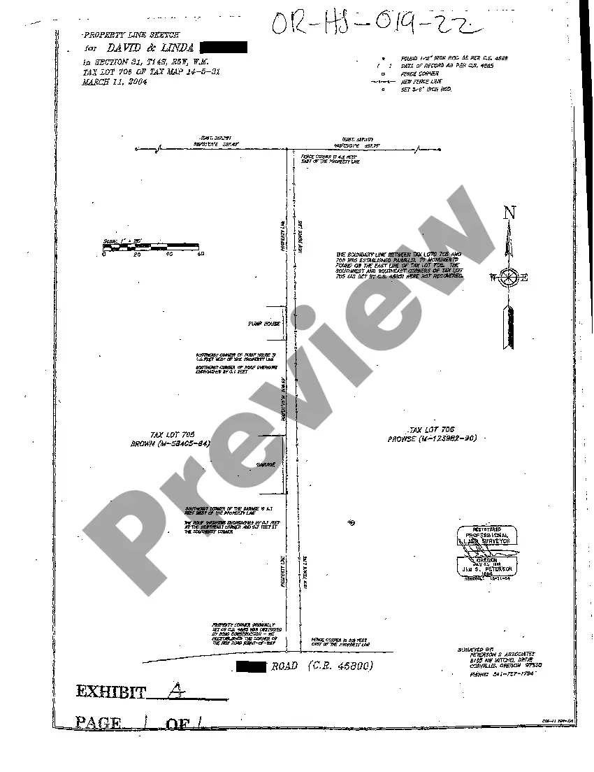
A plat map, also known as a "plat," shows you how a tract of land is divided into lots in your county. It is drawn to scale and records the land's size, boundary locations, nearby streets, flood zones, and any easements or rights of way.
Google Maps will display property lines if you type your address into the 'Search Google Maps' search bar and zoom into the property closely enough. However, property lines are not available on all locations in Google Maps, unfortunately.
Find your property line by visiting your local county recorder or assessor's office. You can access public maps of your street and locate your boundaries. Many counties also let you access property lines online. If your property is on platted land, you may be able to access the plat maps online.
Use the Go To command on your GPS to navigate to each waypoint marking the corner of your land. Please realize that there are limits to the accuracy of your GPS receiver. This technique should get you within a few feet of a property corner and will help you narrow down where to search to find missing survey monuments.
From your plot plan, you can go searching for the markers. Iron stakes mark property lines in most communities. They're typically located at corners and places where property lines meet. You may get lucky and be able to drag a rake over the suspected location and find the iron stake but that is unlikely.