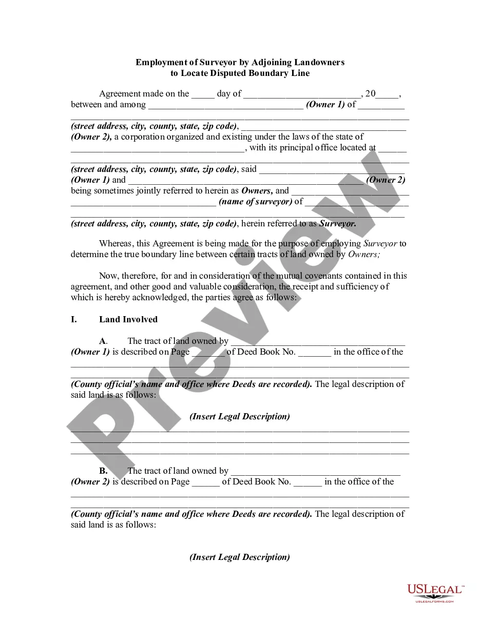
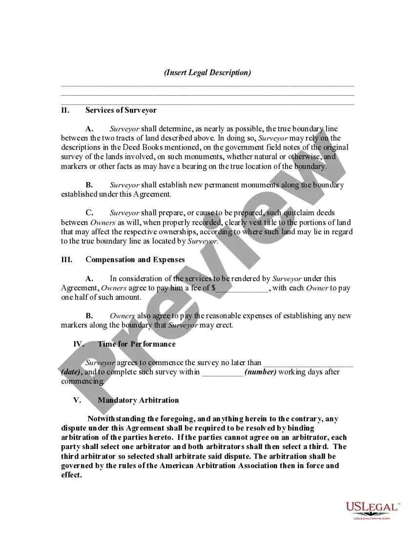
This is a generic sample of an agreement between two adjoining landowners to hire a surveyor to survey their lands in order to settle a dispute as to where the true boundary is regarding their properties.
Pennsylvania Employment of Surveyor by Adjoining Landowners to Locate Disputed Boundary Line When adjoining landowners find themselves in a dispute over the exact location of their property boundaries, the employment of a surveyor in Pennsylvania becomes vital. A surveyor is a professional who specializes in accurately determining property lines and can help establish the boundaries to resolve disputes. The Pennsylvania Employment of Surveyor by Adjoining Landowners to Locate Disputed Boundary Line process begins with the recognition that there is a conflict over the boundary line shared by two adjacent properties. Adjoining landowners can hire a surveyor to conduct a thorough investigation of the disputed area, employing various techniques and tools to determine the precise location of the boundary line. One of the most commonly used techniques by surveyors in Pennsylvania are conducting a boundary survey. This survey involves intricate measurements, research, and analysis to define the exact boundary positions. It often includes the study of historical records, property deeds, and previous survey maps, which helps in identifying any inconsistencies or discrepancies. Another essential part of the Pennsylvania Employment of Surveyor by Adjoining Landowners to Locate Disputed Boundary Line process is performing a field survey. During this phase, the surveyor physically examines the area in question, utilizing advanced equipment such as total stations, GPS receivers, and laser rangefinders. Through meticulous measurements, observations, and data collection, they gather information about the natural features, landmarks, and existing structures within and surrounding the disputed area. Moreover, a surveyor may employ advanced technology like aerial imagery and LiDAR (Light Detection and Ranging) to obtain accurate topographic data and visual representations of the landscape. These tools aid in enhancing the accuracy and efficiency of the survey, further ensuring precise boundary determination. Pennsylvania recognizes the importance of employing a surveyor by adjoining landowners to help resolve boundary disputes. By engaging professional surveying services, landowners can obtain reliable and unbiased evidence to support their claims, making the resolution process fair and transparent. In summary, the Pennsylvania Employment of Surveyor by Adjoining Landowners to Locate Disputed Boundary Line involves hiring a surveyor to conduct a boundary survey and perform a field survey using advanced equipment and technology. This process aids in determining the exact location of property boundaries, resolving disputes between adjoining landowners fairly and accurately.Pennsylvania Employment of Surveyor by Adjoining Landowners to Locate Disputed Boundary Line When adjoining landowners find themselves in a dispute over the exact location of their property boundaries, the employment of a surveyor in Pennsylvania becomes vital. A surveyor is a professional who specializes in accurately determining property lines and can help establish the boundaries to resolve disputes. The Pennsylvania Employment of Surveyor by Adjoining Landowners to Locate Disputed Boundary Line process begins with the recognition that there is a conflict over the boundary line shared by two adjacent properties. Adjoining landowners can hire a surveyor to conduct a thorough investigation of the disputed area, employing various techniques and tools to determine the precise location of the boundary line. One of the most commonly used techniques by surveyors in Pennsylvania are conducting a boundary survey. This survey involves intricate measurements, research, and analysis to define the exact boundary positions. It often includes the study of historical records, property deeds, and previous survey maps, which helps in identifying any inconsistencies or discrepancies. Another essential part of the Pennsylvania Employment of Surveyor by Adjoining Landowners to Locate Disputed Boundary Line process is performing a field survey. During this phase, the surveyor physically examines the area in question, utilizing advanced equipment such as total stations, GPS receivers, and laser rangefinders. Through meticulous measurements, observations, and data collection, they gather information about the natural features, landmarks, and existing structures within and surrounding the disputed area. Moreover, a surveyor may employ advanced technology like aerial imagery and LiDAR (Light Detection and Ranging) to obtain accurate topographic data and visual representations of the landscape. These tools aid in enhancing the accuracy and efficiency of the survey, further ensuring precise boundary determination. Pennsylvania recognizes the importance of employing a surveyor by adjoining landowners to help resolve boundary disputes. By engaging professional surveying services, landowners can obtain reliable and unbiased evidence to support their claims, making the resolution process fair and transparent. In summary, the Pennsylvania Employment of Surveyor by Adjoining Landowners to Locate Disputed Boundary Line involves hiring a surveyor to conduct a boundary survey and perform a field survey using advanced equipment and technology. This process aids in determining the exact location of property boundaries, resolving disputes between adjoining landowners fairly and accurately.