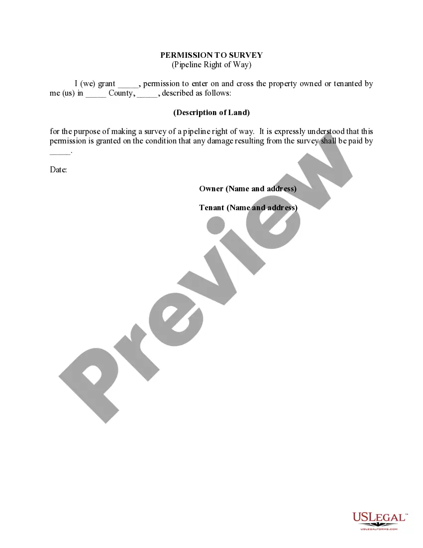
Puerto Rico Permission to Survey (Pipeline Right of Way) is a legal authorization granted by the relevant authorities to conduct surveys for potential pipeline development projects in Puerto Rico. This permission allows authorized entities to survey and access specific land parcels for the purpose of assessing feasibility, designing, and planning the installation of pipelines. The Puerto Rico Permission to Survey (Pipeline Right of Way) is an essential step in the overall process of constructing pipelines as it ensures compliance with regulatory requirements and enables the collection of important data needed for project implementation. To obtain this permission, applicants must go through a thorough application process, including submitting detailed survey plans, environmental impact assessment reports, and relevant supporting documentation. The survey conducted under Puerto Rico Permission to Survey (Pipeline Right of Way) is performed to determine the optimal route for the proposed pipeline, taking into consideration factors like land ownership, terrain, environmental impact, and existing infrastructure. It involves activities such as land surveying, topographic mapping, geotechnical investigations, and other related assessments. The gathered data is then used to design the pipeline route, identify potential challenges, and create mitigation plans. In Puerto Rico, there are different types of Permission to Survey (Pipeline Right of Way) depending on the nature and purpose of the pipeline project. These can include: 1. Preliminary Survey Permission: This type of permission allows for initial surveys to determine the general feasibility of the proposed pipeline project. It focuses on high-level assessment and is typically granted for early-stage projects. 2. Detailed Survey Permission: This permission is granted to conduct an in-depth survey, gathering comprehensive data required for detailed design and engineering of the pipeline. It involves more extensive assessments, such as soil testing, geotechnical investigations, and environmental impact studies. 3. Environmental Survey Permission: This type of permission is specifically granted when there is a need to conduct surveys focused on assessing the potential environmental impact of the pipeline project. It involves wildlife habitat assessments, water quality monitoring, and ecosystem impact evaluations. 4. Archaeological Survey Permission: In cases where the proposed pipeline route may pass through areas of historical or cultural significance, this permission is required to conduct surveys to identify and mitigate any potential archaeological sites or artifacts. Obtaining Puerto Rico Permission to Survey (Pipeline Right of Way) is a crucial step in the process of pipeline development. It ensures adherence to legal and environmental regulations, enables proper planning and design, and helps in minimizing potential risks and impacts to the surrounding areas.
Puerto Rico Permission to Survey (Pipeline Right of Way)
Description
How to fill out Puerto Rico Permission To Survey (Pipeline Right Of Way)?
Are you currently within a place the place you require paperwork for either company or person uses virtually every day time? There are a lot of legitimate record themes accessible on the Internet, but finding versions you can rely on isn`t straightforward. US Legal Forms gives a large number of kind themes, such as the Puerto Rico Permission to Survey (Pipeline Right of Way), which can be written to fulfill state and federal demands.
If you are currently acquainted with US Legal Forms site and have your account, merely log in. After that, you are able to download the Puerto Rico Permission to Survey (Pipeline Right of Way) design.
Should you not offer an accounts and want to begin to use US Legal Forms, follow these steps:
- Get the kind you will need and ensure it is for that correct area/state.
- Utilize the Preview switch to analyze the shape.
- See the explanation to actually have selected the proper kind.
- If the kind isn`t what you`re seeking, utilize the Lookup area to discover the kind that meets your needs and demands.
- Once you find the correct kind, click on Buy now.
- Select the rates program you want, fill out the desired details to create your bank account, and purchase the transaction utilizing your PayPal or Visa or Mastercard.
- Pick a convenient paper format and download your copy.
Discover each of the record themes you possess bought in the My Forms menu. You can get a extra copy of Puerto Rico Permission to Survey (Pipeline Right of Way) at any time, if possible. Just click on the required kind to download or printing the record design.
Use US Legal Forms, the most extensive collection of legitimate varieties, to conserve time and prevent blunders. The services gives skillfully made legitimate record themes which can be used for an array of uses. Make your account on US Legal Forms and initiate producing your way of life easier.
Form popularity
FAQ
Natural gas pipelines do not affect the property value of any particular type of residence any more or less than another type of residence. The sales frequency of homes ?on? the pipeline is consistent with those ?off? the pipeline, indicating that the presence of a pipeline does not inhibit sales.
A pipeline right-of-way is a strip of land over and around natural gas pipelines where some of the property owner's legal rights have been granted to a pipeline operator.
The chances of a pipeline leak or explosion on your property is relatively small, but the consequences can be huge. Knowing what to do, and what not to do, could save your life.
During the pipeline right-of-way surveying process, it's important that you gather detailed information about the proposed route quickly. This can be accomplished using a modern land surveying technology such as unmanned aerial vehicles (UAVs).
A crossing, also known as an encroachment, can be a temporary or permanent structure across, on, along or under a facility or pipeline right-of-way. A crossing can also mean equipment or machinery crossing over the pipeline right-of-way or facility site. Examples of crossings: Installing or replacing fencing.
Above-ground pipeline markers are used along the permanent right-of-way for easy recognition of the presence of underground pipelines. The markers are typically located in a ?line of sight? manner within the rights-of-way, along streets and at road and railroad crossings.
Pipeline Right-of-Ways When a pipeline is first constructed the pipeline owner obtains a contract with the property owner allowing them to use the land for their pipeline. These contracts are referred to as easements, or right-of-ways.
What you need to know. A pipeline right-of-way (ROW) is a strip of land of varying widths that may contain one or more pipelines. To deliver critically needed natural gas via our network, Enbridge must at times cross private and public lands.