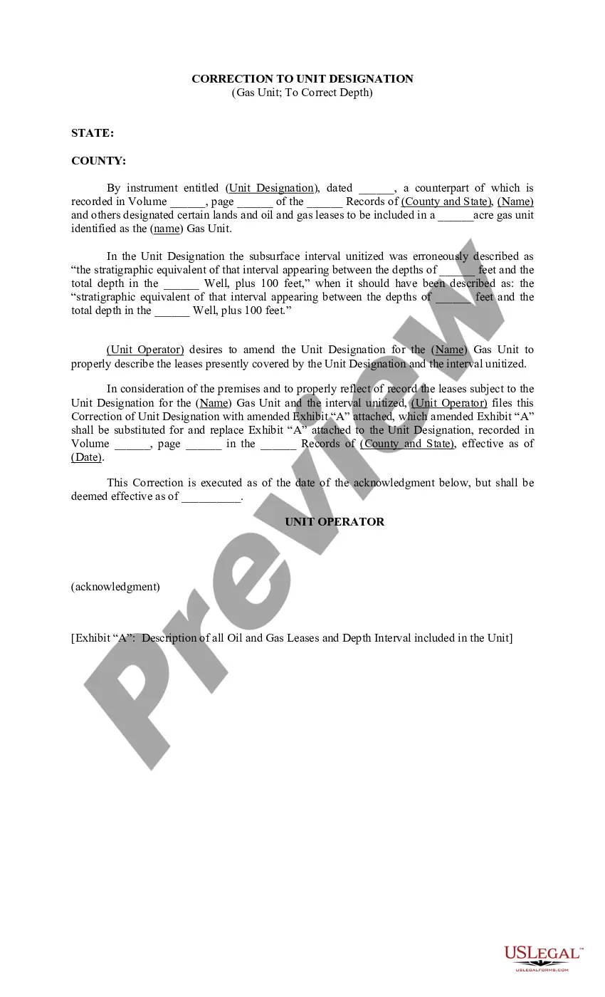
Description: Utah Correction to Unit Designation to Correct Depth refers to the process of correcting inaccuracies or errors in the unit designation of a specific area in Utah, with the aim of ensuring accurate mapping and depth measurement. This correction is essential for accurate geological and geographical assessments, construction planning, resource exploration, and various other applications. Keywords: Utah, correction, unit designation, depth, accurate mapping, geological assessment, geographical assessment, construction planning, resource exploration. Different Types of Utah Correction to Unit Designation to Correct Depth: 1. Geological Unit Correction: This type of correction focuses on accurately identifying and designating geological units within a specific region of Utah. It involves studying the rock formations, sedimentary layers, and other geological features to establish precise unit designations that reflect the actual stratigraphy and lithology of the area for scientific and research purposes. 2. Geographical Unit Correction: Geographical unit correction is concerned with rectifying inaccuracies in the unit designation related to geographical boundaries or divisions within Utah. It encompasses the correction of administrative, political, or geographical subdivisions like counties, provinces, districts, or townships, ensuring accurate representation of the area for administrative, planning, or statistical purposes. 3. Topographical Unit Correction: This type of correction focuses on accurately determining the depth or elevation of specific topographical features within Utah, such as mountains, valleys, canyons, or plateaus. By rectifying any designations or errors in depth measurement, it allows for precise topographic mapping, land surveying, and terrain analysis, benefiting various industries like mining, infrastructure development, or outdoor recreation. 4. Hydrological Unit Correction: Hydrological unit correction involves the accurate designation and correction of unit boundaries related to water bodies, rivers, lakes, or aquifers within Utah. By ensuring accurate identification and delineation of these hydrological features, this correction facilitates effective water management, flood prevention, watershed planning, and conservation efforts in the state. In conclusion, Utah Correction to Unit Designation to Correct Depth is a vital process that encompasses various types of corrections related to accurate mapping, geological assessments, geographical divisions, topographic measurements, and hydrological boundaries within the state. These corrections play a crucial role in ensuring precision, reliability, and usefulness of data for several sectors and industries.
Utah Correction to Unit Designation to Correct Depth
Description
How to fill out Utah Correction To Unit Designation To Correct Depth?
You are able to invest hrs on-line attempting to find the authorized record format that fits the state and federal demands you want. US Legal Forms provides thousands of authorized forms that happen to be reviewed by specialists. It is possible to obtain or produce the Utah Correction to Unit Designation to Correct Depth from our service.
If you currently have a US Legal Forms account, you are able to log in and then click the Acquire option. Afterward, you are able to comprehensive, revise, produce, or sign the Utah Correction to Unit Designation to Correct Depth. Every authorized record format you purchase is your own property for a long time. To get an additional backup of any bought type, visit the My Forms tab and then click the related option.
If you work with the US Legal Forms site for the first time, keep to the basic recommendations under:
- Initially, be sure that you have selected the proper record format for the region/town of your liking. Look at the type description to ensure you have selected the right type. If offered, take advantage of the Review option to check through the record format at the same time.
- If you would like locate an additional variation of your type, take advantage of the Research industry to discover the format that fits your needs and demands.
- Once you have found the format you need, click on Get now to continue.
- Select the pricing plan you need, key in your qualifications, and register for a merchant account on US Legal Forms.
- Full the transaction. You can use your charge card or PayPal account to purchase the authorized type.
- Select the formatting of your record and obtain it to your product.
- Make modifications to your record if necessary. You are able to comprehensive, revise and sign and produce Utah Correction to Unit Designation to Correct Depth.
Acquire and produce thousands of record themes making use of the US Legal Forms website, that offers the largest assortment of authorized forms. Use specialist and express-distinct themes to deal with your small business or personal requirements.