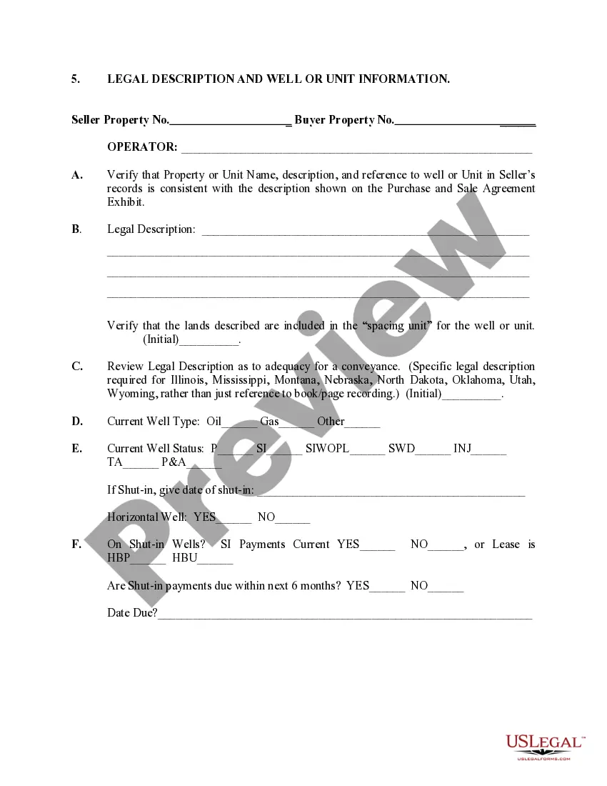
Washington Legal Description is a unique description used in real estate and property transactions within the state of Washington. It serves as a legal representation of a specific parcel of land and provides precise details necessary for identifying and locating the property. The Washington Legal Description includes several key components, such as township, range, section, meridian, and quarter-section information. The legal description starts with the township, which refers to a square tract of land measured in units called "township lines." Each township is further divided into 36 sections, each covering approximately one square mile. The range indicates the location of the township east or west of a designated meridian line. The meridian is a fixed reference line established by the government for surveying purposes. Together, the township, range, and meridian represent the primary grid used to divide and locate land within Washington. Within each section, additional information is provided to further pinpoint the property. This includes describing the quarter-section of land (NW, NE, SW, or SE), the quarter-quarter-section (e.g., SW or NE), and the number of acres or square footage the tract contains. The legal description may also include specific lot numbers, block numbers, or any other relevant information that further defines the boundaries or characteristics of the property. When it comes to Well or Unit Information in Washington, it typically refers to the identification and classification of water wells or oil/gas units within a specific area of the state. In Washington, water wells are categorized based on their purpose and may include irrigation wells, domestic wells, commercial wells, or industrial wells. Each well is assigned a unique identification number, and comprehensive records are kept to ensure regulatory compliance and track the usage and quality of water extracted. On the other hand, unit information often pertains to oil and gas exploration and production activities. In Washington, oil and gas units are designed to establish the boundaries for the extraction and management of these resources. These units involve the grouping of multiple tracts of land to jointly exploit the reserves within a defined area. The details of these units, including boundaries, participating parties, and legal provisions, are recorded and maintained by the Washington Department of Natural Resources. In summary, Washington Legal Description is a precise representation of a property's boundaries using township, range, section, meridian, and quarter-section information. Well or unit information includes the identification of water wells and oil/gas units within the state.
Washington Legal Description and Well or Unit Information
Description
How to fill out Washington Legal Description And Well Or Unit Information?
It is possible to spend hrs on the web trying to find the legitimate record web template which fits the state and federal demands you will need. US Legal Forms supplies 1000s of legitimate kinds that happen to be analyzed by professionals. You can easily acquire or print out the Washington Legal Description and Well or Unit Information from your services.
If you have a US Legal Forms accounts, it is possible to log in and click the Download button. Following that, it is possible to total, modify, print out, or indication the Washington Legal Description and Well or Unit Information. Every legitimate record web template you acquire is your own property for a long time. To have another copy associated with a obtained type, check out the My Forms tab and click the related button.
Should you use the US Legal Forms site initially, adhere to the straightforward directions under:
- Very first, make sure that you have chosen the best record web template for that area/town of your liking. See the type outline to make sure you have selected the proper type. If readily available, use the Preview button to look from the record web template at the same time.
- If you would like get another edition in the type, use the Look for discipline to get the web template that meets your requirements and demands.
- Upon having identified the web template you want, click on Buy now to continue.
- Select the costs program you want, type in your credentials, and register for your account on US Legal Forms.
- Total the transaction. You can utilize your bank card or PayPal accounts to cover the legitimate type.
- Select the formatting in the record and acquire it to your product.
- Make changes to your record if required. It is possible to total, modify and indication and print out Washington Legal Description and Well or Unit Information.
Download and print out 1000s of record themes utilizing the US Legal Forms website, that offers the biggest variety of legitimate kinds. Use professional and condition-distinct themes to take on your business or individual requirements.