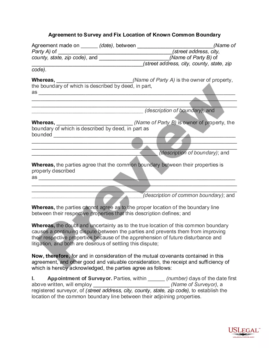
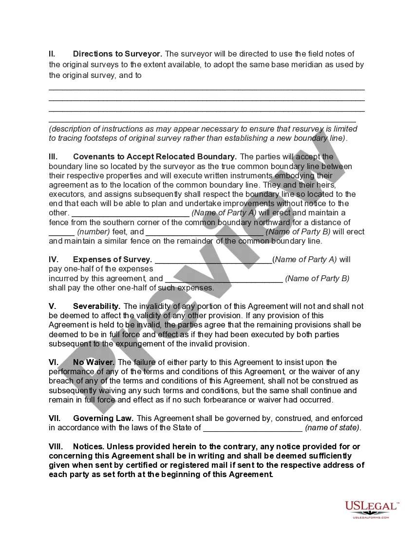
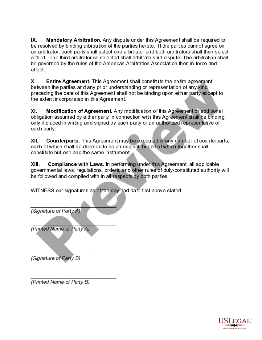
The West Virginia Agreement to Survey and Fix Location of Known Common Boundary is a legal document that is used to establish and settle the exact location of a common boundary between two properties in West Virginia. This agreement is crucial for property owners who share a boundary to avoid potential disputes or misunderstandings in the future. This agreement involves a comprehensive survey of the properties involved, conducted by a professional surveyor or surveying company. The purpose of the survey is to accurately determine the location of the common boundary based on existing markers, landmarks, or other specified criteria. By executing the West Virginia Agreement to Survey and Fix Location of Known Common Boundary, the property owners agree to accept and abide by the results of the survey. The agreement typically outlines the responsibilities of each party, such as sharing the costs of the survey, cooperating with the surveyor, and granting access to their respective properties. To ensure clarity and validity, this agreement often includes a detailed legal description of the properties involved, including their boundary lines, dimensions, and any relevant legal documentation such as deeds or titles. This allows for a precise identification of the properties' boundaries and aids in preventing future boundary disputes. Different types of the West Virginia Agreement to Survey and Fix Location of Known Common Boundary may vary based on the specific circumstances or unique requirements of the properties involved. For example, there may be different agreement forms for residential properties, commercial properties, or land divisions. Additionally, the terms and conditions of the agreement may differ depending on whether the boundary is disputed, needs adjustments, or if there are any existing easements or encroachments. In conclusion, the West Virginia Agreement to Survey and Fix Location of Known Common Boundary is a legal document used to establish and settle the exact location of a shared property boundary. It serves as an essential tool for property owners to prevent future disputes and ensure clarity regarding their property lines.
West Virginia Agreement to Survey and Fix Location of Known Common Boundary
Description
How to fill out West Virginia Agreement To Survey And Fix Location Of Known Common Boundary?
Discovering the right legal document template could be a struggle. Obviously, there are plenty of themes accessible on the Internet, but how can you discover the legal type you need? Use the US Legal Forms internet site. The service gives 1000s of themes, such as the West Virginia Agreement to Survey and Fix Location of Known Common Boundary, which can be used for enterprise and private demands. Each of the types are inspected by pros and fulfill state and federal demands.
Should you be currently registered, log in to the accounts and then click the Obtain switch to have the West Virginia Agreement to Survey and Fix Location of Known Common Boundary. Utilize your accounts to look from the legal types you might have acquired earlier. Visit the My Forms tab of the accounts and acquire one more duplicate of your document you need.
Should you be a new user of US Legal Forms, here are basic directions for you to adhere to:
- Initially, ensure you have selected the right type for the metropolis/area. It is possible to look through the shape while using Preview switch and browse the shape outline to make sure this is basically the best for you.
- If the type is not going to fulfill your requirements, make use of the Seach industry to discover the appropriate type.
- When you are certain the shape is suitable, go through the Buy now switch to have the type.
- Pick the rates program you desire and enter in the essential details. Build your accounts and purchase your order with your PayPal accounts or Visa or Mastercard.
- Pick the document formatting and download the legal document template to the system.
- Complete, revise and printing and indicator the acquired West Virginia Agreement to Survey and Fix Location of Known Common Boundary.
US Legal Forms may be the greatest collection of legal types for which you can discover different document themes. Use the company to download appropriately-manufactured paperwork that adhere to state demands.
Form popularity
FAQ
A Boundary Stake-Out is a type of survey which marks or monuments the physical position of property corners or lines.
West Virginia's most famous boundary is the Mason-Dixon Line, surveyed to settle a border shared at various points by Delaware, Maryland, (West) Virginia, and Pennsylvania.
Traditionally, the surveyor's role in boundary disputes is to assist a court by interpreting onto an accurate plan the position of the "paper title boundary" (the boundary described in the deed that divided the vendor's land), and to support that interpretation with an expert report and with oral evidence given in
It is bordered by Pennsylvania to the north, Maryland and Virginia to the east, Kentucky to the southwest, and Ohio to the northwest.
The starting point of the Big Sandy River, the confluence of the Levisa Fork and Tug Fork, is now the location of Louisa (Kentucky) and Fort Gay (West Virginia).
Surveyors can advise on issues arising from boundary disputes, including how boundaries are defined and how they can be identified.
It is well to observe here that, in terms of geography and history, the Northern Panhandle of the State of West Virginia is a product of the natural boundary formed by the Ohio River on the west and, on the east, of the provisions of the Virginia and Pennsylvania charters, the latter granting to William Penn territory
You must show legal evidence in order to refute a surveyor's findings. If after discussing the problem with the surveyor you still feel it has not been resolved to your satisfaction, there are other avenues that may be pursued. You can hire a land surveyor of your own choice to perform a separate boundary survey.
Virginia, constituent state of the United States of America, one of the original 13 colonies. It is bordered by Maryland to the northeast, the Atlantic Ocean to the southeast, North Carolina and Tennessee to the south, Kentucky to the west, and West Virginia to the northwest.
Hopefully, our approach can help you settle your dispute with ease.Step #1: Recognize the Dispute. The first step towards resolving a property boundary problem is knowing it exists.Step #2: Kindly Approach Your Neighbor.Step #3: Talk with a Lawyer.Step #4: Pursue Mediation.Step #5: File a Lawsuit.