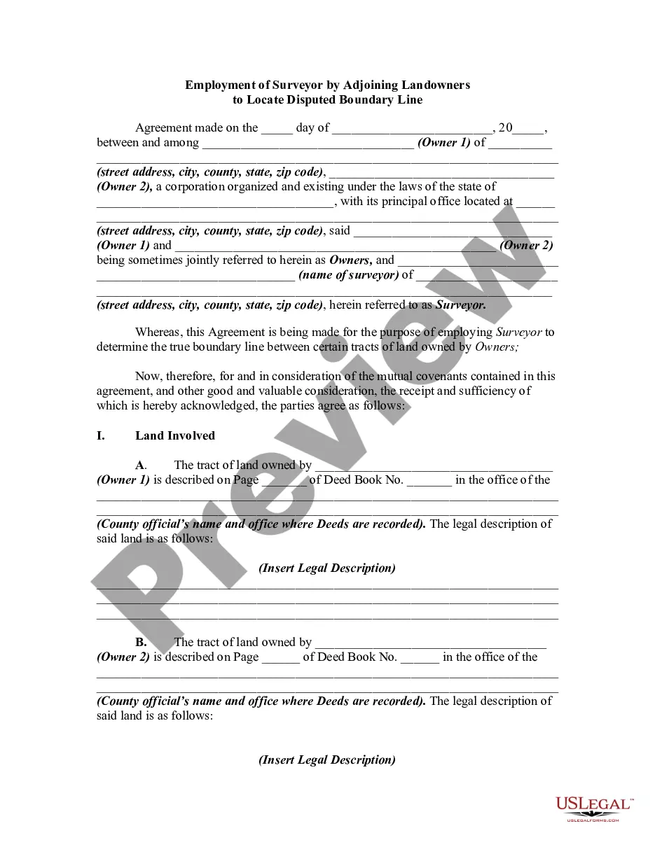
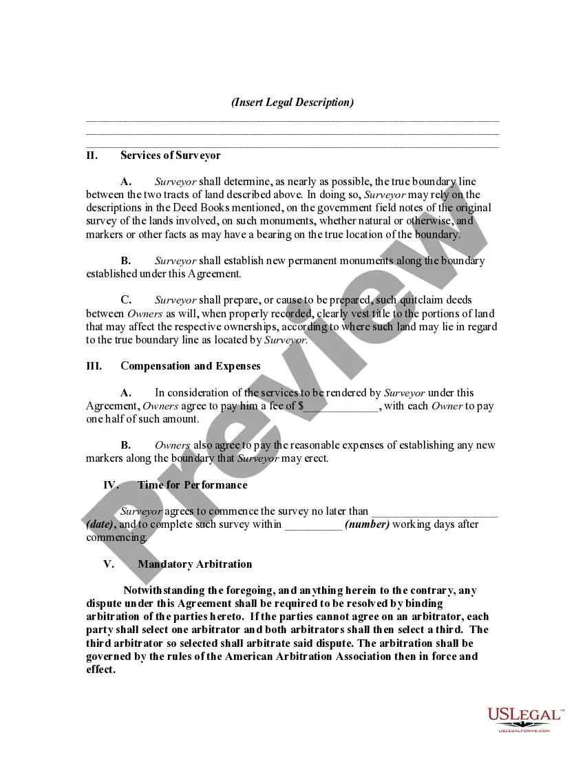
This is a generic sample of an agreement between two adjoining landowners to hire a surveyor to survey their lands in order to settle a dispute as to where the true boundary is regarding their properties.
Oakland Michigan Employment of Surveyor by Adjoining Landowners to Locate Disputed Boundary Line: In Oakland, Michigan, land disputes may arise between adjoining landowners, leading to the necessity of employing a professional surveyor to locate the disputed boundary line. This process involves conducting thorough research, utilizing advanced technology, and presenting an accurate assessment to resolve conflicts and ensure the fair distribution of property. Employing a surveyor in Oakland, Michigan, for boundary disputes offers several benefits. Firstly, the expertise of a surveyor is essential in interpreting legal documents, historical records, and other relevant information to determine the original intent of property boundaries. This comprehensive analysis allows the surveyor to accurately establish the disputed boundary line, providing a strong foundation for resolving conflicts. Adjoining landowners seeking the employment of a surveyor in Oakland, Michigan, can choose from different types of surveying methods depending on the nature of their dispute. Some common types include: 1. Boundary Surveys: This type of survey involves a meticulous examination of both the historical and legal aspects of the property's boundaries. Surveyors carefully assess previously conducted surveys, deeds, and public records to trace the boundaries accurately. 2. ALTA/NPS Land Title Surveys: Adjoining landowners can opt for an ALTA/NPS (American Land Title Association/National Society of Professional Surveyors) survey to address complex land transactions. These surveys adhere to specific standards and are commonly used by commercial property owners or those entering into larger real estate transactions. 3. Topographic Surveys: Topographic surveys involve measuring and mapping the physical features and contours of the land, including elevation changes, trees, structures, water bodies, and any unique characteristics. These surveys can be helpful when determining how the disputed boundary line interacts with the surrounding terrain. 4. GPS/GIS Surveys: Advanced Global Positioning System (GPS) and Geographic Information System (GIS) technologies can aid surveyors in accurately mapping property boundaries. These surveys utilize satellites and specialized software to collect, analyze, and present precise boundary data. Once completed, the surveyor presents his findings to both parties, enabling them to better understand the boundary dispute and work towards a resolution. These professional insights can help avoid unnecessary legal battles and foster neighborly relations among the adjoining landowners in Oakland, Michigan. Overall, the employment of a surveyor in Oakland, Michigan, for locating disputed boundary lines provides a reliable, impartial analysis. Through comprehensive research, advanced technologies, and in-depth knowledge of legal requirements, surveyors play a vital role in resolving these conflicts and ensuring fair property distribution between adjoining landowners.Oakland Michigan Employment of Surveyor by Adjoining Landowners to Locate Disputed Boundary Line: In Oakland, Michigan, land disputes may arise between adjoining landowners, leading to the necessity of employing a professional surveyor to locate the disputed boundary line. This process involves conducting thorough research, utilizing advanced technology, and presenting an accurate assessment to resolve conflicts and ensure the fair distribution of property. Employing a surveyor in Oakland, Michigan, for boundary disputes offers several benefits. Firstly, the expertise of a surveyor is essential in interpreting legal documents, historical records, and other relevant information to determine the original intent of property boundaries. This comprehensive analysis allows the surveyor to accurately establish the disputed boundary line, providing a strong foundation for resolving conflicts. Adjoining landowners seeking the employment of a surveyor in Oakland, Michigan, can choose from different types of surveying methods depending on the nature of their dispute. Some common types include: 1. Boundary Surveys: This type of survey involves a meticulous examination of both the historical and legal aspects of the property's boundaries. Surveyors carefully assess previously conducted surveys, deeds, and public records to trace the boundaries accurately. 2. ALTA/NPS Land Title Surveys: Adjoining landowners can opt for an ALTA/NPS (American Land Title Association/National Society of Professional Surveyors) survey to address complex land transactions. These surveys adhere to specific standards and are commonly used by commercial property owners or those entering into larger real estate transactions. 3. Topographic Surveys: Topographic surveys involve measuring and mapping the physical features and contours of the land, including elevation changes, trees, structures, water bodies, and any unique characteristics. These surveys can be helpful when determining how the disputed boundary line interacts with the surrounding terrain. 4. GPS/GIS Surveys: Advanced Global Positioning System (GPS) and Geographic Information System (GIS) technologies can aid surveyors in accurately mapping property boundaries. These surveys utilize satellites and specialized software to collect, analyze, and present precise boundary data. Once completed, the surveyor presents his findings to both parties, enabling them to better understand the boundary dispute and work towards a resolution. These professional insights can help avoid unnecessary legal battles and foster neighborly relations among the adjoining landowners in Oakland, Michigan. Overall, the employment of a surveyor in Oakland, Michigan, for locating disputed boundary lines provides a reliable, impartial analysis. Through comprehensive research, advanced technologies, and in-depth knowledge of legal requirements, surveyors play a vital role in resolving these conflicts and ensuring fair property distribution between adjoining landowners.