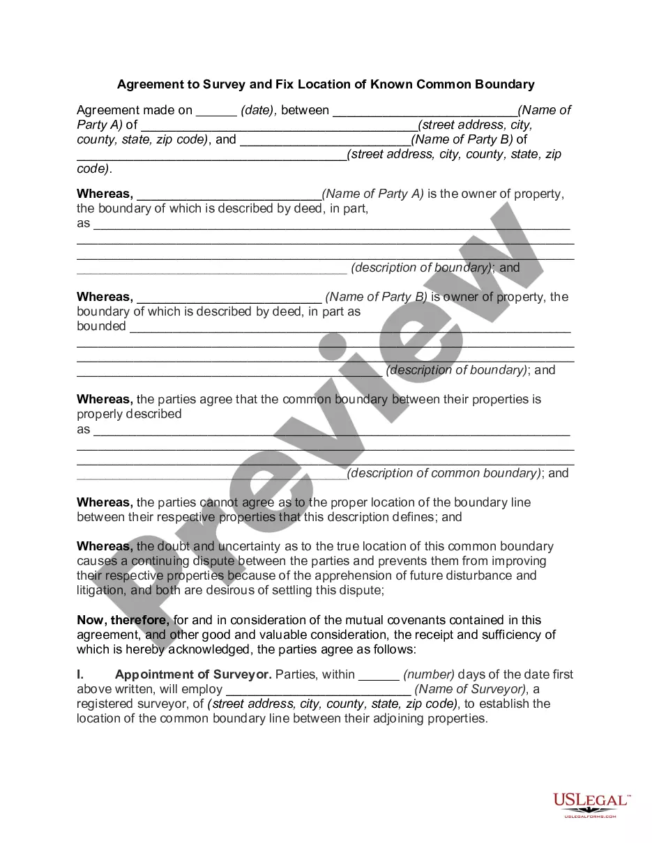
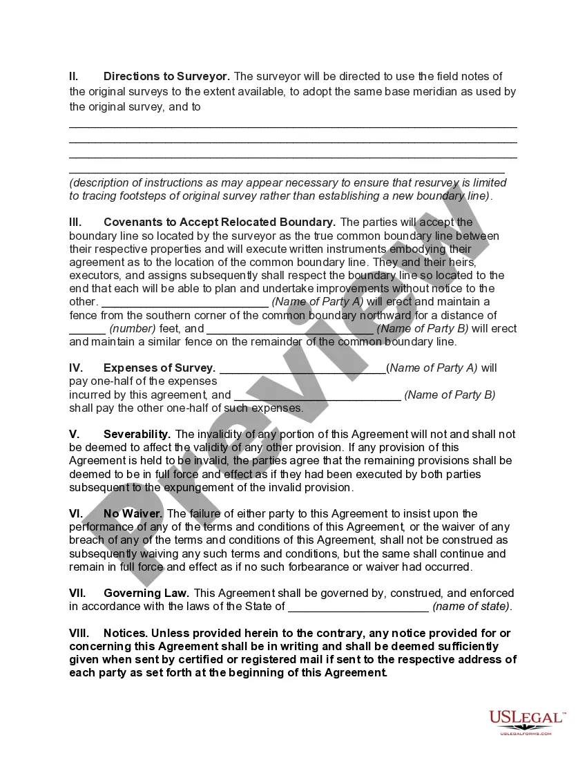
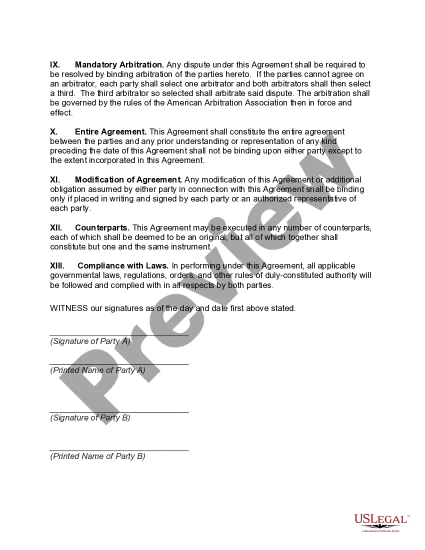
Hennepin Minnesota Agreement to Survey and Fix Location of Known Common Boundary is a legal document that is used to officially establish and confirm the boundary line between properties owned by different parties within Hennepin County, Minnesota. This agreement is designed to resolve any disputes or uncertainties regarding the boundary by conducting a survey and mutually agreeing upon the exact location of the common boundary. The Hennepin Minnesota Agreement to Survey and Fix Location of Known Common Boundary serves as a binding contract between the property owners involved, providing a clear and accurate description of the boundary line to avoid any confusion or future disagreements. By clearly defining the boundary, all parties can feel confident in their respective property rights and obligations. This agreement typically involves hiring a professional surveyor who will conduct a survey of the properties and precisely determine the common boundary line. The surveyor may refer to existing legal descriptions, property deeds, and other relevant documents to ensure accuracy. There may be different types of Hennepin Minnesota Agreements to Survey and Fix Location of Known Common Boundary, depending on the specific circumstances and requirements of the property owners involved. These could include: 1. Mutual Agreement Boundary Determination: This type of agreement is used when the property owners are generally in agreement about the location of the common boundary but wish to formalize the line and provide legal certainty. 2. Boundary Dispute Resolution: This type of agreement is utilized when there is disagreement or uncertainty among the property owners regarding the location of the common boundary. It aims to resolve the dispute through a fair and objective surveying process. 3. Boundary Modification Agreement: In cases where the parties agree to modify the existing boundary to better suit their needs, this type of agreement is employed. It outlines the process of adjusting the common boundary and obtaining any necessary permits or approvals. 4. Preemptive Boundary Agreement: This agreement is often used when two adjacent property owners proactively agree to establish a common boundary to prevent any potential conflicts in the future. It is a precautionary measure that provides clarity and avoids misunderstandings. In conclusion, the Hennepin Minnesota Agreement to Survey and Fix Location of Known Common Boundary is a legally binding document that aims to define the precise location of the boundary line between properties within Hennepin County, Minnesota. By utilizing professional surveying services and mutual agreement, this agreement helps to resolve any disputes, clarify property rights, and provide long-term reassurance to all parties involved.
Hennepin Minnesota Agreement to Survey and Fix Location of Known Common Boundary
Description
How to fill out Hennepin Minnesota Agreement To Survey And Fix Location Of Known Common Boundary?
Whether you intend to start your company, enter into a contract, apply for your ID update, or resolve family-related legal issues, you need to prepare specific paperwork corresponding to your local laws and regulations. Locating the right papers may take a lot of time and effort unless you use the US Legal Forms library.
The service provides users with more than 85,000 professionally drafted and verified legal templates for any individual or business occasion. All files are grouped by state and area of use, so picking a copy like Hennepin Agreement to Survey and Fix Location of Known Common Boundary is quick and easy.
The US Legal Forms website users only need to log in to their account and click the Download key next to the required template. If you are new to the service, it will take you a couple of additional steps to get the Hennepin Agreement to Survey and Fix Location of Known Common Boundary. Follow the instructions below:
- Make certain the sample meets your personal needs and state law regulations.
- Look through the form description and check the Preview if available on the page.
- Use the search tab providing your state above to locate another template.
- Click Buy Now to get the sample once you find the proper one.
- Choose the subscription plan that suits you most to continue.
- Sign in to your account and pay the service with a credit card or PayPal.
- Download the Hennepin Agreement to Survey and Fix Location of Known Common Boundary in the file format you require.
- Print the copy or fill it out and sign it electronically via an online editor to save time.
Forms provided by our website are reusable. Having an active subscription, you can access all of your previously purchased paperwork at any moment in the My Forms tab of your profile. Stop wasting time on a endless search for up-to-date official documentation. Sign up for the US Legal Forms platform and keep your paperwork in order with the most extensive online form collection!
Form popularity
FAQ
LandGlide will find your property and show you the property lines. If you haven't bought a house yet, there are apps that can help find your dream home. LandGlide has a satellite feature that can help you identify where your property lines are. While Google Maps also has boundary lines, LandGlide is more accurate.
To establish a clear boundary, adjoining property owners can decide where they want it to be and then make it so by signing deeds that describe the boundary agreed on. If you have a mortgage on the property, consult a local attorney for help in drawing up the deeds.
Surveying and Mapping is the study of geospatial measurement and representationincluding such disciplines as land surveying, photogrammetry, remote sensing (satelliteimaging and laser scanning), geographic information systems (GIS), cartography, globalpositioning systems (GPS), and some parts of geography and civil
A ?Boundary Survey? is used to identify a property's boundary lines. In this type of survey, the surveyor will set (or recover) the property corners and produce a detailed plat or map.
A survey is the only document that can accurately show your property boundaries. A typical residential lot survey costs approximately $700 to $900. It can be more if your land is irregular in shape or has other unusual features. Surveying is a competitive business and you should obtain estimates from several sources.
How to use GPS on your phone to land survey an area? - YouTube YouTube Start of suggested clip End of suggested clip We need to go to the google play store so we click on icon. And then we go to the search bar. And weMoreWe need to go to the google play store so we click on icon. And then we go to the search bar. And we type in land server app now we click search.
Check with your local government online. City or county governments typically keep land surveys. Do a web search for your city or county records or property office. The office's website typically has information about where surveys are kept.
To apply for land survey in Karnataka you will have to follow the steps given below: Go to the land survey department in your district. Submit an application request land survey of your property along with the required documents. Pay the required fee for land survey in Karnataka.
Boundary Survey This type of land survey is used to locate the corners and property boundary lines of a parcel of land. A boundary survey will use both recorded deeds and physical markers to define the boundary lines on a piece of land. A boundary survey does require both record and field research.
A property line basemap, or a ?plat,? is a drawing that maps out your property's boundary lines and includes details like elevations, bodies of water and structures. You might even be able to find property maps of neighboring properties if you have shared property lines.