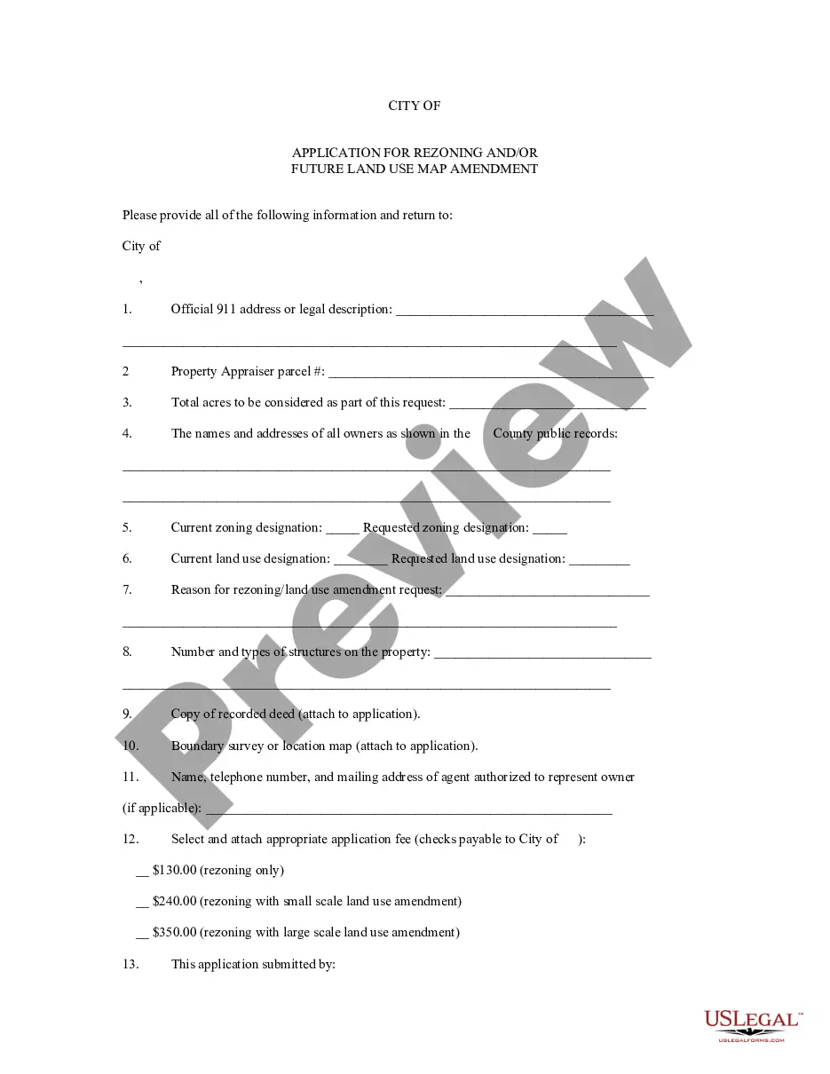
In Alameda, California, the Application for Rezoning and/or Future Land Use Map Amendment plays a crucial role in shaping the city's development and land use plans. This application process is designed to allow individuals, organizations, and businesses to request changes to the zoning and land use designations for specific parcels of land within the city. The City of Alameda recognizes the importance of thoughtful and strategic planning to ensure sustainable growth and maintain the quality of life for its residents. The Application for Rezoning and/or Future Land Use Map Amendment provides thorough guidelines and procedures for applicants to follow when seeking changes to zoning designations or land use classifications. The application process typically initiates when an applicant submits a formal request to the Alameda Planning Department. This request includes a detailed explanation of the desired changes, along with supporting documents such as site plans, environmental impact reports, and proposed land use regulations. The application must comply with the Alameda General Plan, which outlines the city's long-term vision for land use and development. Applicants may seek different types of amendments through the Alameda California Application for Rezoning and/or Future Land Use Map Amendment. These may include: 1. Rezoning Requests: These applications involve a change in the zoning designation for a particular property. Zoning determines how a specific area of land can be used and what types of structures can be built. For example, an applicant may request a change from residential to commercial zoning or vice versa. 2. General Plan Amendments: General Plan Amendments aim to modify the Future Land Use Map, which identifies the intended land use categories for different areas within the city. These amendments play a crucial role in altering land use designations for large-scale developments or reconfiguration of land use patterns. 3. Overlay District Requests: An overlay district is an additional set of zoning regulations that are applied to a specific area on top of the existing zoning designations. Overlay districts are often used to address unique circumstances or implement specialized land use policies. An applicant may seek the creation or modification of an overlay district through the Application for Rezoning and/or Future Land Use Map Amendment to accommodate specific development goals or protect environmentally sensitive areas. The Alameda California Application for Rezoning and/or Future Land Use Map Amendment process involves thorough review and evaluation by the Alameda Planning Department, which considers factors such as consistency with the General Plan, compatibility with surrounding land uses, environmental impacts, community input, and other relevant criteria. Public hearings and workshops may be held to gather feedback from residents, stakeholders, and agencies before final decisions are made. The goal of the Alameda California Application for Rezoning and/or Future Land Use Map Amendment is to ensure a transparent, accountable, and inclusive approach to land use planning that aligns with the city's long-term vision and respects community needs. By accommodating requests for rezoning and future land use changes responsibly, Alameda can continue to optimize its growth, manage urban development effectively, and enhance the overall quality of life for its residents.
Alameda California Application for Rezoning and / or Future Land Use Map Amendment
Description

How to fill out Alameda California Application For Rezoning And / Or Future Land Use Map Amendment?
Creating paperwork, like Alameda Application for Rezoning and / or Future Land Use Map Amendment, to manage your legal affairs is a tough and time-consumming task. A lot of situations require an attorney’s involvement, which also makes this task expensive. However, you can get your legal affairs into your own hands and handle them yourself. US Legal Forms is here to save the day. Our website comes with more than 85,000 legal forms created for different cases and life circumstances. We make sure each document is compliant with the laws of each state, so you don’t have to be concerned about potential legal problems associated with compliance.
If you're already familiar with our website and have a subscription with US, you know how effortless it is to get the Alameda Application for Rezoning and / or Future Land Use Map Amendment form. Simply log in to your account, download the template, and personalize it to your requirements. Have you lost your document? No worries. You can get it in the My Forms folder in your account - on desktop or mobile.
The onboarding process of new customers is fairly simple! Here’s what you need to do before getting Alameda Application for Rezoning and / or Future Land Use Map Amendment:
- Ensure that your template is specific to your state/county since the rules for writing legal papers may vary from one state another.
- Learn more about the form by previewing it or reading a brief intro. If the Alameda Application for Rezoning and / or Future Land Use Map Amendment isn’t something you were hoping to find, then take advantage of the search bar in the header to find another one.
- Log in or register an account to start utilizing our service and download the form.
- Everything looks good on your side? Hit the Buy now button and select the subscription option.
- Pick the payment gateway and enter your payment information.
- Your template is good to go. You can go ahead and download it.
It’s an easy task to locate and purchase the appropriate document with US Legal Forms. Thousands of organizations and individuals are already benefiting from our extensive library. Subscribe to it now if you want to check what other advantages you can get with US Legal Forms!