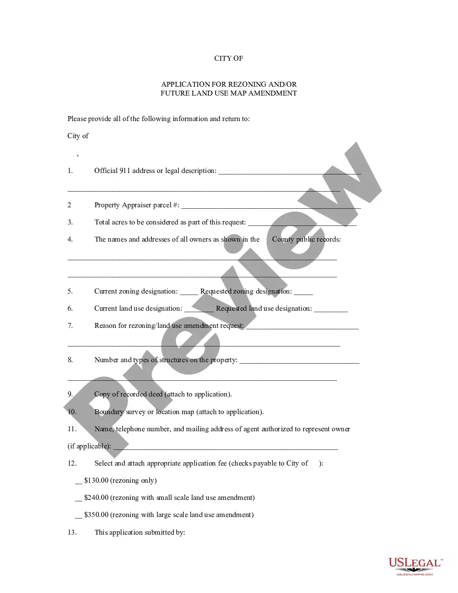
Houston Texas has a well-established process for rezoning and future land use map amendment applications. These applications play a critical role in shaping the development and land use policies within the city. Let's dive into the details of what these processes entail and the different types of applications involved. Rezoning in Houston refers to the process of changing the zoning designation of a specific parcel of land or property. Zoning determines how land can be used, indicating whether it is meant for residential, commercial, industrial, or other purposes. The Houston Texas Application for Rezoning allows property owners, developers, or interested parties to request a change in the zoning classification of a particular area. The rezoning application involves submitting specific information to the City of Houston Planning and Development Department. This information typically includes the legal description of the property, a detailed statement of the requested change, and an explanation of how the proposed rezoning aligns with the overall development objectives of the city. It is crucial to research and comply with the existing Houston Development Code and comprehensive plan to ensure the success of the application. On the other hand, Houston's Future Land Use Map Amendment applications deal with modifying the future land use designation for a particular area. It is an opportunity to update the long-term land use plans for the city and implement new visions for development. Future land use maps help guide decision-making and provide direction for developing infrastructure, transportation systems, parks, and housing. Similar to rezoning applications, the Future Land Use Map Amendment application involves submitting relevant details to the City of Houston Planning and Development Department. The application should include a thorough description of the proposed changes, reasons for amendment, and how it aligns with the city's comprehensive plan. The department then reviews the application, considering factors such as existing land uses, community input, infrastructure availability, and potential impacts. Different types of rezoning and future land use map amendment applications may include: 1. Residential to Commercial Rezoning: Requests to change the zoning classification of a residential area to accommodate commercial developments, such as retail centers, office complexes, or mixed-use projects. 2. Industrial to Residential Rezoning: Applications seeking to repurpose industrial zones for residential use, allowing the development of housing units or communities in previously industrial areas. 3. Mixed-Use Zoning: Proposals to designate specific areas as mixed-use, allowing for a combination of residential, commercial, and sometimes industrial activities within the same district. 4. Open Space to Development Rezoning: Involves changing the use designation of open or green spaces to permit development projects, which may include residential, commercial, or recreational facilities. 5. Future Land Use Map Amendment for Transportation Corridors: Requests for modifying the future land use designations along major transportation corridors to accommodate transportation-related infrastructure, such as highways, rail lines, or transit-oriented developments. It is important to note that each application is evaluated on a case-by-case basis, considering various factors such as neighborhood compatibility, infrastructure capacity, environmental impact assessments, and community engagement. The City of Houston strives to ensure responsible and sustainable development practices while accommodating the city's evolving needs and goals.
Houston Texas Application for Rezoning and / or Future Land Use Map Amendment
Description
How to fill out Houston Texas Application For Rezoning And / Or Future Land Use Map Amendment?
A document routine always accompanies any legal activity you make. Staring a company, applying or accepting a job offer, transferring ownership, and lots of other life situations demand you prepare official documentation that varies throughout the country. That's why having it all collected in one place is so valuable.
US Legal Forms is the largest online library of up-to-date federal and state-specific legal templates. Here, you can easily find and get a document for any individual or business purpose utilized in your county, including the Houston Application for Rezoning and / or Future Land Use Map Amendment.
Locating forms on the platform is amazingly simple. If you already have a subscription to our service, log in to your account, find the sample using the search field, and click Download to save it on your device. Afterward, the Houston Application for Rezoning and / or Future Land Use Map Amendment will be available for further use in the My Forms tab of your profile.
If you are using US Legal Forms for the first time, adhere to this simple guideline to obtain the Houston Application for Rezoning and / or Future Land Use Map Amendment:
- Make sure you have opened the correct page with your local form.
- Utilize the Preview mode (if available) and browse through the sample.
- Read the description (if any) to ensure the form satisfies your requirements.
- Search for another document via the search tab if the sample doesn't fit you.
- Click Buy Now once you locate the necessary template.
- Decide on the appropriate subscription plan, then log in or create an account.
- Select the preferred payment method (with credit card or PayPal) to proceed.
- Choose file format and save the Houston Application for Rezoning and / or Future Land Use Map Amendment on your device.
- Use it as needed: print it or fill it out electronically, sign it, and file where requested.
This is the simplest and most trustworthy way to obtain legal paperwork. All the templates provided by our library are professionally drafted and verified for correspondence to local laws and regulations. Prepare your paperwork and manage your legal affairs efficiently with the US Legal Forms!
Form popularity
FAQ
Houston is the only big American city without zoning. Some people argue that Houston is effectively zoned, as many neighborhoods have deed restrictions that limit development.
The biggest difference, of course, is the lack of zoning ? but what that really means in Houston is that there is no zoning for use. Under the city's development code, no parcel of land is restricted for any particular land use, and in many cases, there are no density or height restrictions either.
How do I obtain a plat or replat? A plat, or replat, is filed at Harris County Records Office after approval and after recordation by the landowner. You may request a copy from Harris County via email CCO.CCInfo@hctx.net or by phone 713-274-6390.
The City of Houston does not have zoning, but development is governed by ordinance codes that address how property can be subdivided. The City codes do not address land use.
The Planning & Development Department's mission is to grow and preserve Houston's diverse communities to create a resilient city.
The City of Houston requires a minimum three-foot side setback for all properties, unless an easement or other agreement allows a smaller distance. On a corner lot, the building must be at least 10 feet from a ?local? street on street-facing sides.
The exact amount a building needs to be set back from the property line will vary from one location to another. However, the required setback on the side is typically between 5 ? 10 feet, while the front and back require around 10 ? 20 feet at a minimum.
As the fourth largest city in the nation, Houston is the only major U.S. city that doesn't have a zoning ordinance.
FEE SCHEDULE: A base fee of $300.00 + $25.00 per lot (if applicable) is the required fee to be paid to the County. All amounts are due upon presentation of the application.
More info
The application should give the property ownership information in the “owner” and “tenant” sections. If you are the owner of an interest in this property, and you are not sure of the correct address, please contact the city of Crowley's Office of Real Estate at. I have read the above information and understand the rules and regulations listed above. I accept the information above. Now for the application. Please fill out all the required, yellowish boxes. If you have a question regarding the application, please contact the city of Crowley's Office of Real Estate at. You have read the above information and accept the information above. Now for the application. Please fill out all the boxes in color. You are to be informed by the city of Crowley's Office of Real Estate that you have been awarded the property. Please print this page (245 N Getty St): Filling in the “Owner / Tenant” column. Note: Fill in the “Owner / Tenant” column.
Disclaimer
The materials in this section are taken from public sources. We disclaim all representations or any warranties, express or implied, as to the accuracy, authenticity, reliability, accessibility, adequacy, or completeness of any data in this paragraph. Nevertheless, we make every effort to cite public sources deemed reliable and trustworthy.