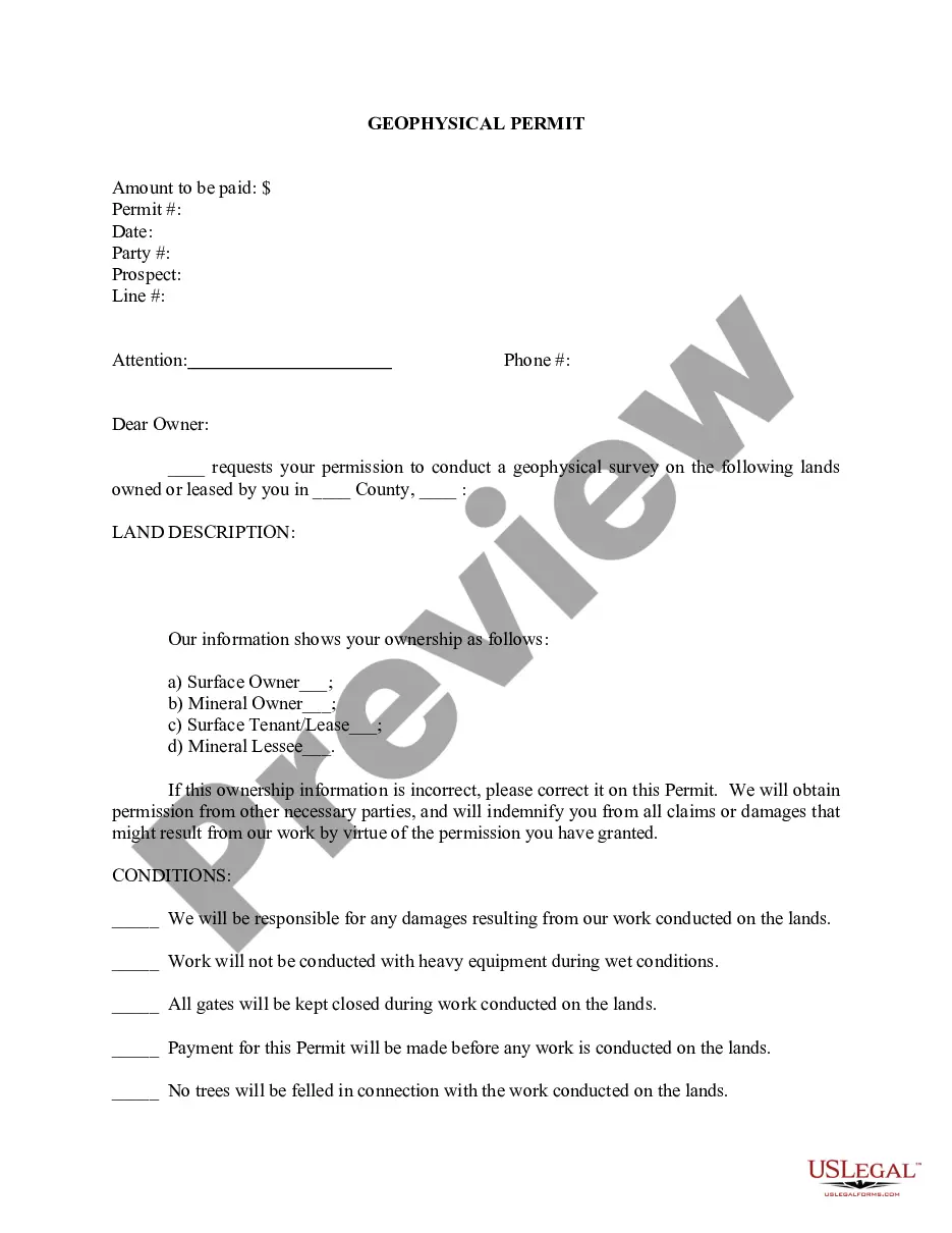
Collin Texas Geophysical Permit is a legal authorization required for conducting geophysical activities in Collin County, Texas. It involves acquiring seismic data, conducting surveys, or performing other geophysical investigations within the geographical boundaries of Collin County. This permit ensures that geophysical activities are conducted safely, minimally impacting the environment, and in compliance with local regulations. Some relevant keywords associated with Collin Texas Geophysical Permit include: 1. Geophysical activities: Refers to scientific methods utilized to study the physical properties and behavior of the Earth's subsurface, such as seismic surveys, ground-penetrating radar, gravity and magnetic surveys, etc. 2. Collin County: The specific geographical area in Texas where the geophysical activities will take place, known for its diverse landscapes and economic significance. 3. Authorization: The legal permission granted to individuals or organizations to carry out geophysical investigations within Collin County. 4. Compliance: Adhering to local laws, regulations, and guidelines set forth by the county authorities to maintain environmental sustainability and public safety during geophysical operations. 5. Seismic data: Information acquired through the use of seismic techniques, which helps in mapping underground structures, identifying potential natural resources, evaluating the feasibility of construction projects, etc. 6. Environmental impact: Ensuring that the geophysical activities do not cause any harm to the local flora, fauna, water bodies, or overall ecosystem, and implementing necessary mitigation measures. 7. Safety regulations: The protocols, guidelines, and safety measures set by local authorities to prevent accidents, protect workers, and ensure community safety during geophysical investigations. 8. Data usage: The permitted utilization and sharing of geophysical data acquired during the activities, which is often crucial for research purposes, resource extraction planning, infrastructure development, and other related applications. Types of Collin Texas Geophysical Permits may include: 1. Seismic Survey Permit: This permit specifically authorizes the conduct of seismic surveys, which involve the propagation of energy waves through the ground to produce subsurface images for various purposes like oil and gas exploration, geological research, or engineering projects. 2. Ground-Penetrating Radar (GPR) Permit: Geophysical investigations utilizing ground-penetrating radar technology provide non-destructive subsurface images, often used for infrastructure planning, archaeological research, or studying soil composition, among other applications. 3. Gravity and Magnetic Surveys Permit: These permits address geophysical investigations involving measuring variations in gravity and magnetic fields to identify subsurface anomalies, locate minerals, or assess geological formations for resource extraction or research purposes. It is important to note that the specific types of permits and their names may vary depending on local regulations and the specific requirements of Collin County regarding geophysical activities.
Collin Texas Geophysical Permit
Description

How to fill out Collin Texas Geophysical Permit?
Laws and regulations in every sphere vary from state to state. If you're not a lawyer, it's easy to get lost in various norms when it comes to drafting legal documents. To avoid costly legal assistance when preparing the Collin Geophysical Permit, you need a verified template legitimate for your county. That's when using the US Legal Forms platform is so helpful.
US Legal Forms is a trusted by millions online catalog of more than 85,000 state-specific legal forms. It's a perfect solution for specialists and individuals looking for do-it-yourself templates for various life and business scenarios. All the documents can be used multiple times: once you pick a sample, it remains available in your profile for further use. Therefore, if you have an account with a valid subscription, you can simply log in and re-download the Collin Geophysical Permit from the My Forms tab.
For new users, it's necessary to make a couple of more steps to get the Collin Geophysical Permit:
- Analyze the page content to make sure you found the right sample.
- Use the Preview option or read the form description if available.
- Search for another doc if there are inconsistencies with any of your criteria.
- Click on the Buy Now button to obtain the template when you find the appropriate one.
- Choose one of the subscription plans and log in or sign up for an account.
- Choose how you prefer to pay for your subscription (with a credit card or PayPal).
- Select the format you want to save the document in and click Download.
- Fill out and sign the template on paper after printing it or do it all electronically.
That's the easiest and most cost-effective way to get up-to-date templates for any legal reasons. Find them all in clicks and keep your paperwork in order with the US Legal Forms!
Form popularity
FAQ
Geophysical survey is a broad term covering the suite of detection methods used to map contrasts between the physical properties of buried archaeological remains and the surrounding soil.
3) How long do geophysical surveys take? Geophysical surveys can require anywhere from several hours to several weeks to complete depending upon the size of the area of interest, the depth of investigation, the geophysical method used, and the amount of survey coverage required.
The primary types of data held by the GSQ include: 2D and 3D seismic data. airborne geophysical data. gravity data. deep seismic reflection surveys. magnetotellurics (MT) surveys.
Guideline Geo´s wide range of geophysical investigation techniques can solve a number of the most common questions that arise during the exploration phase of a mining project. They will give a non-destructive and cost-efficient way of gaining a better understanding of the sub-surface conditions.
Geophysical surveys are performed from the soil surface, through boreholes, excavations or in a combination of placing sources and detectors. The survey scope, the method types and work techniques depend on the survey purpose, the available funds, the geological and topographic conditions.
35 C H A P T E R 4 Geophysical Investigations Introduction Geophysical investigations are used to estimate the physical properties of the subsurface by measuring, analyzing, and interpreting seismic, electrical, electromagnetic, gravitational, and magnetic fields measured at the ground surface or within boreholes.
Geophysical data is used to provide information on the physical properties of the Earth's surface and subsurface. As a result, geophysical data can help locate hydrocarbons, minerals, aggregate, and other natural resources.
Geophysical surveys are used in industry as well as for academic research. The sensing instruments such as gravimeter, gravitational wave sensor and magnetometers detect fluctuations in the gravitational and magnetic field.
Airborne geophysical surveys collect data from air either using a helicopter or a fixed wing aircraft. Generally magnetic, radiometry and electromagnetic data are collected from the air at the same time. Sometime gravity data is also collected together with other geophysical data.