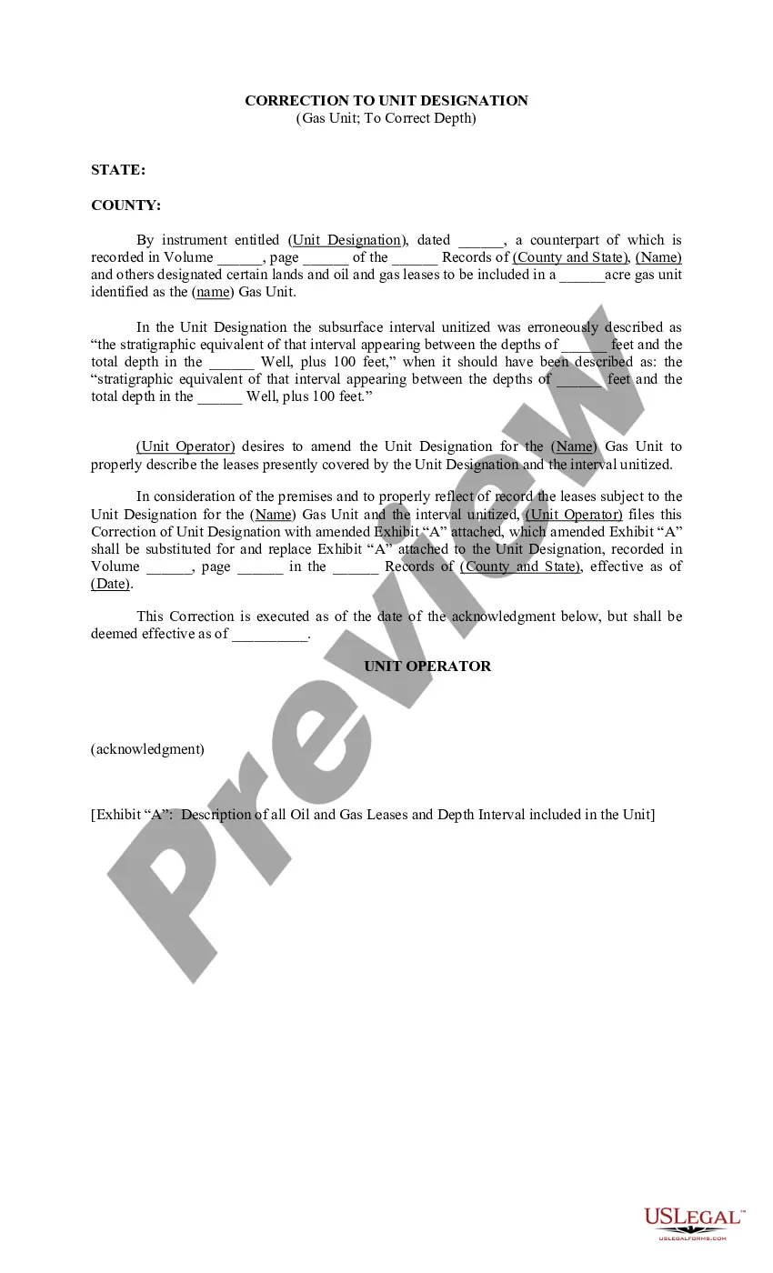
Cuyahoga Ohio Correction to Unit Designation to Correct Depth refers to the process of rectifying errors in the unit designation of a specific region in Cuyahoga County, Ohio, to ensure accurate depth measurements. This correction is necessary to maintain precision in various applications such as land surveying, mapping, construction projects, and resource management. The correction process involves identifying and resolving inaccuracies in the depth measurement system associated with the unit designation of the Cuyahoga Ohio region. The depth measurement system is crucial for understanding the topography and spatial characteristics of the area, ensuring accurate planning and development activities. There are different types of Cuyahoga Ohio Correction to Unit Designation to Correct Depth, namely: 1. Geographic Information System (GIS) Correction: In this type, GIS technology is utilized to assess and correct geographic data associated with the unit designation. It involves analyzing digital maps, satellite imagery, and other geospatial data sources to identify inconsistencies and update the depth measurements accordingly. 2. Surveying and Mapping Correction: This type focuses on rectifying errors in the unit designation through traditional surveying and mapping techniques. Surveyors collect field data using various instruments such as total stations and GPS devices, enabling them to accurately measure depths and update the unit designation accordingly. 3. Database Correction: This correction type involves updating the internal databases used for managing depth measurements in the Cuyahoga Ohio region. Data entry errors and inconsistencies in the unit designation are identified and rectified to ensure accurate depth information is available for different purposes. 4. Depth Measurement Protocol Correction: In this type, the protocols and procedures used for measuring depths in the Cuyahoga Ohio region are assessed and modified to improve accuracy. This may involve revising measurement techniques, equipment calibration, and quality control processes to ensure consistent and precise depth data collection. Cuyahoga Ohio Correction to Unit Designation to Correct Depth is a vital process to maintain accurate and reliable depth measurements in the region. It ensures that planning, construction, environmental management, and other activities are based on precise and up-to-date information, benefiting both local communities and various stakeholders involved in the development of Cuyahoga County, Ohio.
Cuyahoga Ohio Correction to Unit Designation to Correct Depth
Description
How to fill out Cuyahoga Ohio Correction To Unit Designation To Correct Depth?
A document routine always accompanies any legal activity you make. Opening a business, applying or accepting a job offer, transferring property, and many other life situations demand you prepare official paperwork that differs from state to state. That's why having it all accumulated in one place is so helpful.
US Legal Forms is the biggest online collection of up-to-date federal and state-specific legal templates. On this platform, you can easily locate and download a document for any individual or business purpose utilized in your region, including the Cuyahoga Correction to Unit Designation to Correct Depth.
Locating samples on the platform is amazingly simple. If you already have a subscription to our service, log in to your account, find the sample through the search field, and click Download to save it on your device. Following that, the Cuyahoga Correction to Unit Designation to Correct Depth will be accessible for further use in the My Forms tab of your profile.
If you are using US Legal Forms for the first time, adhere to this simple guide to get the Cuyahoga Correction to Unit Designation to Correct Depth:
- Make sure you have opened the right page with your localised form.
- Utilize the Preview mode (if available) and scroll through the sample.
- Read the description (if any) to ensure the template satisfies your requirements.
- Search for another document using the search tab if the sample doesn't fit you.
- Click Buy Now when you locate the required template.
- Select the suitable subscription plan, then sign in or register for an account.
- Select the preferred payment method (with credit card or PayPal) to continue.
- Choose file format and download the Cuyahoga Correction to Unit Designation to Correct Depth on your device.
- Use it as needed: print it or fill it out electronically, sign it, and file where requested.
This is the simplest and most reliable way to obtain legal documents. All the samples available in our library are professionally drafted and verified for correspondence to local laws and regulations. Prepare your paperwork and run your legal affairs efficiently with the US Legal Forms!