Mecklenburg North Carolina Geoscience Operations on the Contract Area

State:
Multi-State
County:
Mecklenburg
Control #:
US-OG-705
Format:
Word; 
Rich Text
Instant download

Description

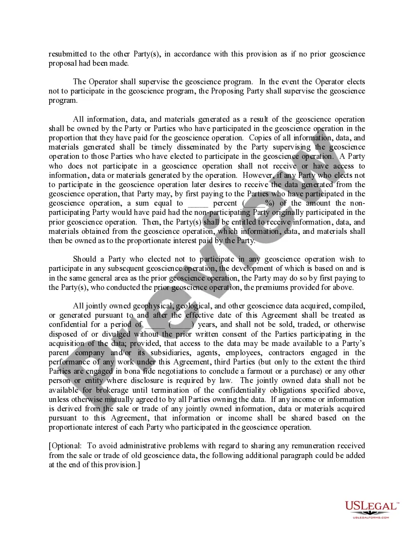
This form provides that any Party may propose that geoscience operations be conducted on the Contract Area lands. The Party wishing to conduct geoscience operations shall furnish the other Parties with an information notice which generally describes the proposed geoscience operation.

Mecklenburg County in North Carolina, USA, hosts various geoscience operations within its contract area. Geoscience operations encompass a range of disciplines such as geology, geophysics, and hydrology, with the goal of studying Earth's physical properties, processes, and resources. These operations play a vital role in understanding and managing the local geological and environmental conditions. 1. Geological Surveys: Mecklenburg County's geoscience operations include comprehensive geological surveys of the contract area. These surveys involve collecting and analyzing data to characterize the region's rock formations, mineral deposits, and geological hazards. Geological surveys help in mapping the subsurface structures, understanding the history of the land, and identifying potential risks. 2. Geochemical Analysis: Mecklenburg's geoscience operations often involve geochemical analysis to study the chemical compositions of rocks, minerals, soil, and water in the contract area. By analyzing elemental and isotopic compositions, geoscientists can infer geological processes, identify natural resource potential, and assess environmental impacts. 3. Geophysical Mapping: Geoscience operations in Mecklenburg County also encompass geophysical mapping techniques. These methods utilize various instruments to measure physical properties of Earth materials and identify subsurface structures. Geophysical surveys, like seismic reflection and ground-penetrating radar, assist in locating underground water resources, assessing soil stability, and detecting potential geological hazards. 4. Hydro geological Studies: Another vital aspect of Mecklenburg's geoscience operations focuses on hydro geological studies. These investigations involve assessing the distribution, movement, and quality of groundwater in the contract area. By analyzing aquifer characteristics, groundwater flow patterns, and water chemistry, hydro geologists help in sustainable water resource management and studying potential contamination sources. 5. Environmental Impact Assessment: Mecklenburg County's geoscience operations may extend to conducting environmental impact assessments (Bias) for developmental projects. Bias investigates potential impacts on the geology, hydrology, and ecosystems of the contract area. By evaluating potential effects on local geology, surface water, and habitats, geoscientists help in making informed decisions to mitigate adverse environmental consequences. 6. Geotechnical Investigations: Geoscience operations on the contract area in Mecklenburg County may also involve geotechnical investigations. Geotechnical studies assess soil properties, foundation stability, and slope stability for construction and infrastructure projects. By analyzing soil samples, conducting site-specific geophysical surveys, and evaluating geotechnical data, engineers can design safe and resilient structures. Overall, Mecklenburg County's geoscience operations cover a broad spectrum of activities, including geological surveys, geochemical analysis, geophysical mapping, hydro geological studies, environmental impact assessment, and geotechnical investigations. These interdisciplinary efforts aim to enhance our understanding of the region's geological framework, natural resources, and potential risks, thereby contributing to sustainable development and wise land-use decisions.

Free preview
  • Form preview
  • Form preview
  • Form preview

How to fill out Mecklenburg North Carolina Geoscience Operations On The Contract Area?

A document routine always accompanies any legal activity you make. Creating a business, applying or accepting a job offer, transferring property, and many other life scenarios require you prepare official paperwork that varies from state to state. That's why having it all accumulated in one place is so beneficial.

US Legal Forms is the most extensive online library of up-to-date federal and state-specific legal templates. Here, you can easily find and download a document for any personal or business objective utilized in your county, including the Mecklenburg Geoscience Operations on the Contract Area.

Locating forms on the platform is extremely simple. If you already have a subscription to our library, log in to your account, find the sample using the search bar, and click Download to save it on your device. Following that, the Mecklenburg Geoscience Operations on the Contract Area will be accessible for further use in the My Forms tab of your profile.

If you are dealing with US Legal Forms for the first time, follow this simple guideline to get the Mecklenburg Geoscience Operations on the Contract Area:

  1. Make sure you have opened the correct page with your localised form.
  2. Make use of the Preview mode (if available) and browse through the sample.
  3. Read the description (if any) to ensure the form satisfies your needs.
  4. Search for another document using the search option if the sample doesn't fit you.
  5. Click Buy Now when you find the required template.
  6. Decide on the suitable subscription plan, then log in or register for an account.
  7. Select the preferred payment method (with credit card or PayPal) to continue.
  8. Opt for file format and download the Mecklenburg Geoscience Operations on the Contract Area on your device.
  9. Use it as needed: print it or fill it out electronically, sign it, and send where requested.

This is the simplest and most trustworthy way to obtain legal paperwork. All the templates provided by our library are professionally drafted and verified for correspondence to local laws and regulations. Prepare your paperwork and run your legal affairs effectively with the US Legal Forms!

Form popularity

FAQ

In 1802, Reed's father took that 17 pound nugget to a jeweler in Fayetteville who swindled it away from the family. He bought it for $3.50, which is equivalent to about $65 in today's coin.

Streams such as Little Buffalo Creek in Rowan and Cabarrus Counties, Dutch Buffalo Creek in Cabarrus County, Cabin Creek in Moore County, the Uwharrie River in Montgomery County and streams in the South Mountain area might be good places to try panning.

In North Carolina, you are not allowed to carry off any rocks or minerals from state parks or recreation areas. You cannot hunt, pan or dig for minerals on private property without the permission of the property owner.

Reed Gold Mine is in Midland, North Carolina, and is where the first documented gold was discovered in the United States. According to Reed Gold Mine, then-12-year-old Conrad Reed was playing near Little Meadow Creek in 1799 when he found a 17-pound yellow rock.

In North Carolina, you are not allowed to carry off any rocks or minerals from state parks or recreation areas. You cannot hunt, pan or dig for minerals on private property without the permission of the property owner.

Mecklenburg County contained more mines and prospects than any other county in the state. The most important mines in Mecklenburg County were the Capps, Rudisil and St. Catherine Mines. Other counties in the slate belt where gold was mined include Guilford, Montgomery, Moore, Orange, Randolph, Stanly and Union.

It's possible to find small amounts of gold in the stream sediments, or placers. Although North Carolina has many quartz veins, it is rare to find one that contains gold.

Celebration of 23 Pound Gold Nugget Discovery in 1896 at Reed Gold Mine April 9. The 1890s saw new owners of Reed Gold Mine and the discovery of one of the largest gold nuggets in North Carolina history.

If you're going to prospect near The Coves Mountain River Club, you'll want to check out Wilson's Creek and the Johns River for placer gold. The north side of Lower Creek, below Lenoir, is another good spot. And the stream gravel around Grandmother's Mountain yields good results.

More info

Manager he was responsible for the operations of 22 landfills in the states of Texas,. Stakeholder Engagement Plan. Stakeholders.Introduction of the technical diving method for scientific diving to investigate biocoenosis in the twilight zone of freshwater lakes. 1911Department and title . Amount of contract .

Trusted and secure by over 3 million people of the world’s leading companies

Mecklenburg North Carolina Geoscience Operations on the Contract Area