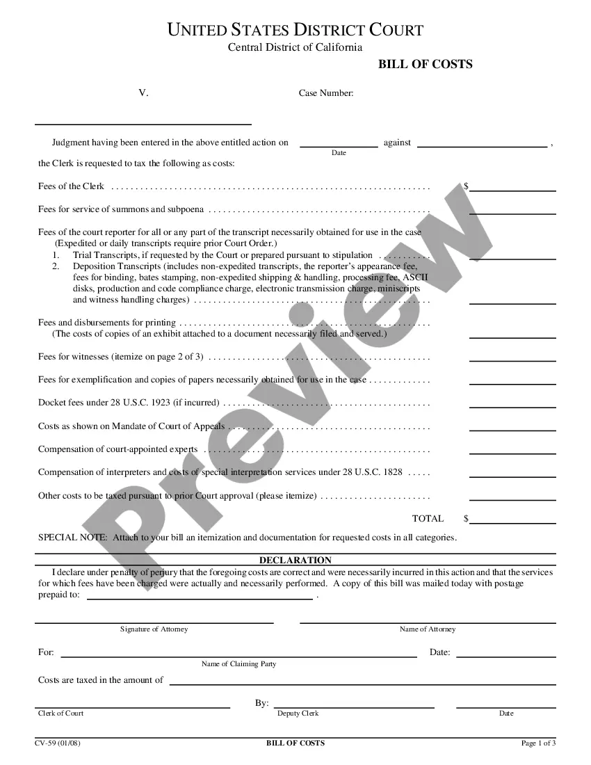
This form is used when the Parties agree and shall contribute all proprietary seismic data and all non-proprietary seismic data affecting the Contract Area in its possession as of the effective date of this Agreement, to the extent the data is not restricted by confidentiality or licensing agreements with third parties. It is specifically understood and agreed that each Party has the right to sell, trade, and/or otherwise market seismic data involving the Contract Area which was in its possession prior to the effective date of this Agreement, and the benefits and advantages, including monetary consideration, which it receives as a result of those activities shall be the sole property of the party who owns the data.
Phoenix Arizona Seismic Data and Operations refer to the comprehensive process of collecting, analyzing, and interpreting seismic data in the Phoenix, Arizona region. Seismic data is obtained through the use of specialized instruments that measure and record ground vibrations caused by various natural and artificial sources, including earthquakes, explosions, and human activities. The primary objective of Phoenix Arizona Seismic Data and Operations is to monitor and understand the seismic activity in the region. This data plays a crucial role in identifying potential earthquake hazards, evaluating geological structures and subsurface properties, and aiding in urban planning and infrastructure development. It also helps in assessing the impact of industrial operations on the environment and investigating the feasibility of underground energy projects such as geothermal power. There are several types of Phoenix Arizona Seismic Data and Operations, including: 1. Seismic Monitoring: Continuously monitoring and recording ground motions in real-time using networks of seismometers strategically placed across the region. These seismometers capture both local and distant earthquakes, allowing experts to accurately measure the magnitude, location, and depth of seismic events. 2. Seismic Tomography: By analyzing the arrival times and amplitudes of seismic waves at different stations, researchers can generate three-dimensional images of the subsurface. Seismic tomography helps understand the geological structure and identify potential pathways for underground water resources, natural resources, and geologic hazards. 3. Seismic Hazard Assessment: Utilizing historical seismic data combined with advanced modeling techniques, seismologists can quantify the level of seismic hazard across the region. This information assists in designing buildings and infrastructure, establishing building codes, and developing emergency response plans to mitigate the impact of potential earthquakes. 4. Induced Basicity Monitoring: With the increase in human activities like mining, oil and gas extraction, and geothermal energy, it is important to monitor and study any seismic events triggered by these operations. Induced basicity monitoring focuses on detecting and evaluating earthquakes induced by human activities to ensure safety and sustainability in these industries. 5. Educational Outreach: Phoenix Arizona Seismic Data and Operations also involve conducting educational programs and workshops to raise public awareness about earthquakes, their impact, and mitigation strategies. These initiatives aim to empower the community with knowledge and preparedness measures that can minimize risks associated with seismic events. The collection, analysis, and interpretation of Phoenix Arizona Seismic Data and Operations are crucial for understanding the seismic behavior of the region, preparing for potential earthquakes, and ensuring the safety and well-being of individuals and infrastructure. Through these operations, scientists can better assess geological hazards, inform urban planning decisions, and contribute to sustainable development practices in Phoenix, Arizona.
Phoenix Arizona Seismic Data and Operations refer to the comprehensive process of collecting, analyzing, and interpreting seismic data in the Phoenix, Arizona region. Seismic data is obtained through the use of specialized instruments that measure and record ground vibrations caused by various natural and artificial sources, including earthquakes, explosions, and human activities. The primary objective of Phoenix Arizona Seismic Data and Operations is to monitor and understand the seismic activity in the region. This data plays a crucial role in identifying potential earthquake hazards, evaluating geological structures and subsurface properties, and aiding in urban planning and infrastructure development. It also helps in assessing the impact of industrial operations on the environment and investigating the feasibility of underground energy projects such as geothermal power. There are several types of Phoenix Arizona Seismic Data and Operations, including: 1. Seismic Monitoring: Continuously monitoring and recording ground motions in real-time using networks of seismometers strategically placed across the region. These seismometers capture both local and distant earthquakes, allowing experts to accurately measure the magnitude, location, and depth of seismic events. 2. Seismic Tomography: By analyzing the arrival times and amplitudes of seismic waves at different stations, researchers can generate three-dimensional images of the subsurface. Seismic tomography helps understand the geological structure and identify potential pathways for underground water resources, natural resources, and geologic hazards. 3. Seismic Hazard Assessment: Utilizing historical seismic data combined with advanced modeling techniques, seismologists can quantify the level of seismic hazard across the region. This information assists in designing buildings and infrastructure, establishing building codes, and developing emergency response plans to mitigate the impact of potential earthquakes. 4. Induced Basicity Monitoring: With the increase in human activities like mining, oil and gas extraction, and geothermal energy, it is important to monitor and study any seismic events triggered by these operations. Induced basicity monitoring focuses on detecting and evaluating earthquakes induced by human activities to ensure safety and sustainability in these industries. 5. Educational Outreach: Phoenix Arizona Seismic Data and Operations also involve conducting educational programs and workshops to raise public awareness about earthquakes, their impact, and mitigation strategies. These initiatives aim to empower the community with knowledge and preparedness measures that can minimize risks associated with seismic events. The collection, analysis, and interpretation of Phoenix Arizona Seismic Data and Operations are crucial for understanding the seismic behavior of the region, preparing for potential earthquakes, and ensuring the safety and well-being of individuals and infrastructure. Through these operations, scientists can better assess geological hazards, inform urban planning decisions, and contribute to sustainable development practices in Phoenix, Arizona.