San Diego California Geophysical and Seismic Operations

State:
Multi-State
County:
San Diego
Control #:
US-OG-800
Format:
Word; 
Rich Text
Instant download

Description

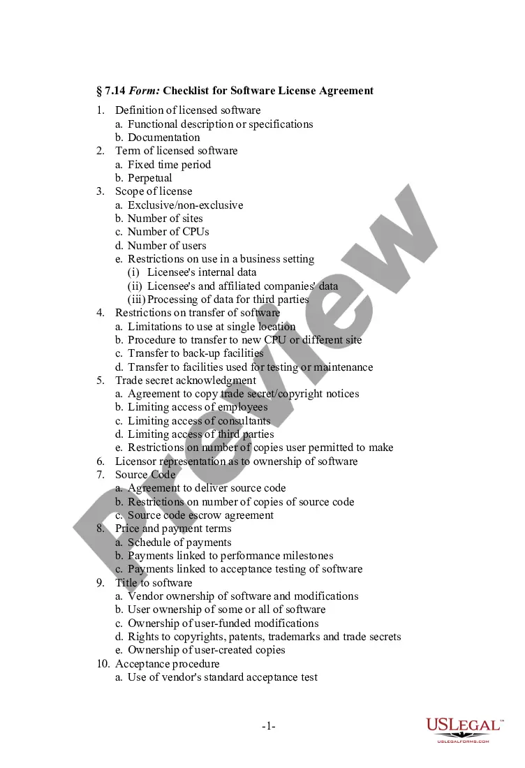
This lease rider form may be used when you are involved in a lease transaction, and have made the decision to utilize the form of Oil and Gas Lease presented to you by the Lessee, and you want to include additional provisions to that Lease form to address specific concerns you may have, or place limitations on the rights granted the Lessee in the “standard” lease form.

San Diego, California is a hub for various geophysical and seismic operations due to its diverse landscape, geological features, and proximity to major fault lines. Geophysical and seismic operations in San Diego involve the study, exploration, mapping, and monitoring of subsurface formations, rock structures, and seismic activities, contributing to a better understanding of the region's geological processes. One prominent type of geophysical and seismic operation in San Diego is seismic surveys. These surveys utilize advanced instruments and techniques to measure and record seismic waves that travel through the Earth's layers. Geophysicists and seismologists use this data to investigate soil and rock properties, identify potential hazards, study fault lines, and assess the geological suitability for various construction projects. Another important aspect of geophysical and seismic operations in San Diego is subsurface imaging and mapping. Through the use of advanced imaging technologies like ground-penetrating radar, electromagnetic surveys, and magnetometer, geophysicists create detailed maps of the subsurface features. These maps provide valuable information about underground structures, potential groundwater reserves, detecting buried utilities, and identifying geological formations suitable for resource exploration. San Diego is also known for its seismic monitoring and early warning systems. With an extensive network of seismic sensors and stations, scientists and researchers continuously monitor seismic activities in the region. This monitoring allows for the detection of seismic events, localization of earthquake epicenters, and assessment of ground shaking intensity. Such data is crucial for emergency preparedness, urban planning, and ensuring the safety of the population. Furthermore, San Diego houses research institutions and organizations that specialize in seismic hazard assessment and earthquake engineering. These entities conduct studies to evaluate the vulnerability of infrastructure, buildings, and critical facilities to seismic activities. By analyzing soil liquefaction potential, ground motion amplification, and structural dynamics, they aim to develop strategies for mitigating earthquake risks and enhancing the resilience of the built environment. In summary, geophysical and seismic operations in San Diego, California encompasses a wide range of activities, including seismic surveys, subsurface imaging, seismic monitoring, and earthquake engineering. These operations play a significant role in advancing our knowledge of the local geology, improving hazard assessment, and ensuring the safety of communities in the region.

Free preview
  • Form preview
  • Form preview

How to fill out San Diego California Geophysical And Seismic Operations?

How much time does it typically take you to draw up a legal document? Given that every state has its laws and regulations for every life scenario, finding a San Diego Geophysical and Seismic Operations meeting all regional requirements can be exhausting, and ordering it from a professional attorney is often pricey. Numerous web services offer the most common state-specific templates for download, but using the US Legal Forms library is most advantegeous.

US Legal Forms is the most comprehensive web catalog of templates, grouped by states and areas of use. Aside from the San Diego Geophysical and Seismic Operations, here you can find any specific document to run your business or personal affairs, complying with your regional requirements. Professionals verify all samples for their validity, so you can be sure to prepare your paperwork properly.

Using the service is pretty straightforward. If you already have an account on the platform and your subscription is valid, you only need to log in, choose the required sample, and download it. You can get the file in your profile at any time later on. Otherwise, if you are new to the website, there will be a few more steps to complete before you obtain your San Diego Geophysical and Seismic Operations:

  1. Examine the content of the page you’re on.
  2. Read the description of the template or Preview it (if available).
  3. Look for another document utilizing the related option in the header.
  4. Click Buy Now when you’re certain in the selected file.
  5. Decide on the subscription plan that suits you most.
  6. Create an account on the platform or log in to proceed to payment options.
  7. Make a payment via PalPal or with your credit card.
  8. Switch the file format if needed.
  9. Click Download to save the San Diego Geophysical and Seismic Operations.
  10. Print the doc or use any preferred online editor to fill it out electronically.

No matter how many times you need to use the acquired document, you can locate all the files you’ve ever downloaded in your profile by opening the My Forms tab. Give it a try!

Form popularity

FAQ

The easiest way is to find out200b200b if a property is located in a Seismic Hazard Zone is to use the California Earthquake Hazards Zone Application200b200b or search our collection of online maps. You can also visit one of the California Geological Survey offices200b (call ahead), or your city or county office.

Geotechnical reports are considered valid for ten (10) years unless the geotechnical consultant identifies a shorter expiration date.

How long is a Geotechnical Report Valid For: The expiry date often stipulated by Councils in New Zealand is 10 years.

The term Geotech report is commonly used in the building industry but can refer to many types of geotechnical investigations and reports or assessments that can range in cost from $700 up to $3,000+. Before a cost can be determined, we need to identify what soil testing is required.

Standard geotechnical reports are generally between $2500 to $4000.

Parts of the geotechnical report Location and surface conditions: specific address, current use, surface coverings, elevation, drainage, etc. Subsurface exploration data: soil profile, exploration logs, lab or in-situ test results, ground water conditions. Interpretation and analysis of data.

All of San Diego County is located within Seismic Zone 4 (Sec. 1629.4. 1 of the CBC), which is the highest Seismic Zone, and like most of Southern California, is subject to ground shaking.

Zone 3. This zone is classified as a Moderate Damage Risk Zone which is liable to MSK VII. The IS code assigns a zone factor of 0.16 for Zone 3. Several megacities like Chennai, Mumbai, Kolkata and Bhubaneshwar lie in this zone.

It is often a requirement of the local council that a Geotechnical Report or Soil Report be provided for a building development as part of the Building Consent process. It is common for the report to be referred to as simply the geotech report.

Two maps of revised Earthquake Fault Zones have been prepared for the Rose Canyon Fault where it comes onshore on Coronado Island and traverses the San Diego area to the northwest and goes back offshore near La Jolla. Each of these maps covers a roughly 60-square-mile quadrangle of territory.

Interesting Questions

More info

III-7 Schematic Drawing Of Magnetometry Operating Principles . III-15. III-8 Summary Of Geophysical Methods For Locating.Echo Seismic Ltd is a full service geophysical exploration company with global capabilities. 4D seismic started in the early 1980's and became commercial in the late 1990's. Benthic provides complete end-to-end support for accurate and timely geophysical surveys, including survey design, execution and data interpretation. Some types of geophysical well logs can be done during any phase of a well's history: drilling, completing, producing, or abandoning. Seismic operations management and support. Delivering on client's seismic goals. 11.2 Mortality in narwhals linked to seismic survey noise . A different blue whale population showed the opposite reaction.

Trusted and secure by over 3 million people of the world’s leading companies

San Diego California Geophysical and Seismic Operations