Bronx New York Survey of Lands included in Producing Or Proration Units

State:
Multi-State
County:
Bronx
Control #:
US-OG-831
Format:
Word; 
Rich Text
Instant download

Description

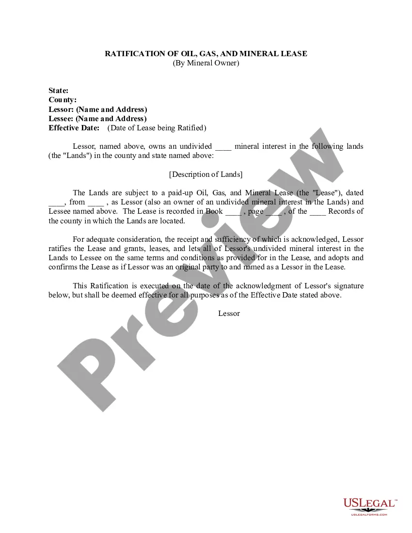
This lease rider form may be used when you are involved in a lease transaction, and have made the decision to utilize the form of Oil and Gas Lease presented to you by the Lessee, and you want to include additional provisions to that Lease form to address specific concerns you may have, or place limitations on the rights granted the Lessee in the “standard” lease form.

The Bronx, located in New York City, is one of the five boroughs and covers an area of approximately 42 square miles. Known for its rich history and diverse communities, the Bronx offers a variety of land survey options for producing or proration units. These surveys play a crucial role in determining land boundaries and are essential for real estate development, construction projects, and land management. Here are some types of surveys included in producing or proration units in the Bronx: 1. Boundary Survey: A boundary survey helps identify and establish property lines, easements, and rights of way. It ensures legal compliance and helps prevent boundary disputes between neighboring properties. 2. Topographic Survey: A topographic survey provides a detailed representation of the physical features of the land, including contours, vegetation, structures, and natural terrain. It helps in understanding the existing conditions and assists in designing infrastructure or development projects. 3. ALTA/NPS Land Title Survey: ALTA/NPS surveys provide a comprehensive evaluation of a property's boundary lines, improvements, easements, encroachments, and other factors affecting its marketability. These surveys are typically conducted to facilitate real estate transactions and comply with lender requirements. 4. Subdivision Survey: Subdivision surveys are carried out to divide larger parcels of land into smaller lots for development or sale. They involve the measurement and mapping of new property boundaries, rights of way, and the creation of legal descriptions. 5. Construction Survey: Construction surveys are performed during the construction phase of a project to ensure accurate placement of structures, utilities, roadways, and other features as per the design plans. 6. Elevation Certificate: Elevation certificates are essential for floodplain management and insurance purposes. They document the elevation of buildings relative to the base flood elevation and assess flood risk. 7. As-built Survey: As-built surveys are conducted upon completion of a construction project to verify that the constructed features are in accordance with the approved design plans and specifications. 8. Municipal Improvement Survey: These surveys focus on specific public infrastructure projects and involve mapping out improvements such as roads, sidewalks, utilities, drainage systems, and other public facilities. Bronx New York's survey of lands included in producing or proration units ensures accurate measurement and recording of various land attributes. These surveys are vital for establishing legal boundaries, supporting development projects, maintaining public safety, and managing land resources effectively.

How to fill out Bronx New York Survey Of Lands Included In Producing Or Proration Units?

How much time does it normally take you to draft a legal document? Given that every state has its laws and regulations for every life sphere, finding a Bronx Survey of Lands included in Producing Or Proration Units meeting all regional requirements can be tiring, and ordering it from a professional lawyer is often pricey. Many web services offer the most common state-specific templates for download, but using the US Legal Forms library is most advantegeous.

US Legal Forms is the most extensive web collection of templates, collected by states and areas of use. Apart from the Bronx Survey of Lands included in Producing Or Proration Units, here you can get any specific document to run your business or personal deeds, complying with your county requirements. Specialists check all samples for their validity, so you can be sure to prepare your documentation correctly.

Using the service is pretty simple. If you already have an account on the platform and your subscription is valid, you only need to log in, choose the needed form, and download it. You can get the document in your profile at any moment later on. Otherwise, if you are new to the platform, there will be a few more actions to complete before you get your Bronx Survey of Lands included in Producing Or Proration Units:

  1. Check the content of the page you’re on.
  2. Read the description of the template or Preview it (if available).
  3. Look for another document utilizing the corresponding option in the header.
  4. Click Buy Now once you’re certain in the selected document.
  5. Decide on the subscription plan that suits you most.
  6. Sign up for an account on the platform or log in to proceed to payment options.
  7. Pay via PalPal or with your credit card.
  8. Switch the file format if needed.
  9. Click Download to save the Bronx Survey of Lands included in Producing Or Proration Units.
  10. Print the doc or use any preferred online editor to fill it out electronically.

No matter how many times you need to use the acquired template, you can locate all the files you’ve ever saved in your profile by opening the My Forms tab. Give it a try!

Form popularity

FAQ

If you own land, you have property rights. This means you can harvest anything that grows from your land, or build whatever you want on your land. To own oil or any other mineral coming from your land, you must have mineral rights in addition to your property rights.

NDIC has generally approved one well per 1,280-acre spacing unit (one square mile) for each formation or two adjacent 640-acre sections. But some companies have been allowed to drill one well per 640-acre section. Some have even downspaced to two wells per 640-acre section (320-acre spacing).

1. n. Oil and Gas Business The amount of acreage, determined by governmental authority that can be efficiently and economically drained by a well at a particular depth or horizon.

Field rules might establish density rules of 40 acres per well up to 640 acres per well. Density rules for gas reservoirs generally provide for larger proration units than oil wells because wells in conventional gas reservoirs are able to drain a larger area than wells in conventional oil reservoirs.

NDIC has generally approved one well per 1,280-acre spacing unit (one square mile) for each formation or two adjacent 640-acre sections. But some companies have been allowed to drill one well per 640-acre section. Some have even downspaced to two wells per 640-acre section (320-acre spacing).

Results of the analysis indicate that approximately 117,500 acres (183 mi2) of total land disturbance was associated with drill pads and related roads in the UCRB in 1991. The estimated area of disturbed land associated with oil and gas development increased 53 percent to 179,400 acres (280 mi2) in 2007.

There are those in the oil and gas industry who believe to prorate a reservoir means to take or produce at equal rates from all wells in the reservoir regardless of the quality of the wells or the reserves underlying them.

Every gas well drilled in such pool: a) Shall be on a drilling unit consisting of (1) one hundred sixty (160) contiguous surface acres, or (2) a governmental quarter section containing not less than one hundred forty- four (144) acres or more than one hundred seventy-six (176) acres.

The process of drilling and completing an oil or gas well is obviously going to cause disturbance to the surface. A typical footprint needed for drilling, completion, and subsequent production is generally in the 3 to 10 acre range.

More info

Missing: Bronx ‎Proration Which costs are included in the contract amount.Generally, the contract will include a clause that allows the owner to review or audit those costs. In the meantime, they had also purchased the land at Hunts Point and were arranging for the construction of large manufacturing units at that place. The contract of sale provides a blueprint for the closing documents. For a house, that documentation will include: i. Air Pollution Removal. 35. The unit owner's successive defaults to the mortgagee, the mortgage will. (unless otherwise provided in the declaration or bylaws) be subject to. Effects of Changes in Position Allocations on the Filling of Positions.

Trusted and secure by over 3 million people of the world’s leading companies

Bronx New York Survey of Lands included in Producing Or Proration Units